MAP DETAILS | |
|---|---|
| TITLE | Port Henry |
| STATE | Vermont, New York |
| LOCATION | Vicinity of Vergennes, 25 miles south of Burlington |
| SERIES | 15-minute |
| SURVEYED | 1892 Field Survey |
| GEOGRAPHER | Henry Gannett |
| ENGRAVED | 1894 |
| EDITION | 1898 |
| PRINTED | 1913 |
| PRINT NOTES | Thick paper stock |
| SCALE | 1:62500 |
| CONTOUR INTERVAL | 20 feet |
| SHEET DIMENSIONS | 16 1/2 x 20 inches |
| MAP DIMENSIONS | 12 1/2 x 17 1/2 inches |
| COVERAGE AREA | 12 x 17 miles |
| SOURCE | From an uncommonly well-preserved collection |
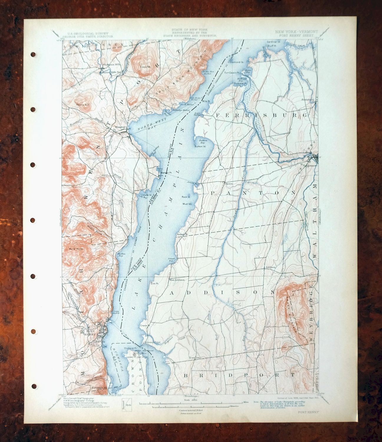
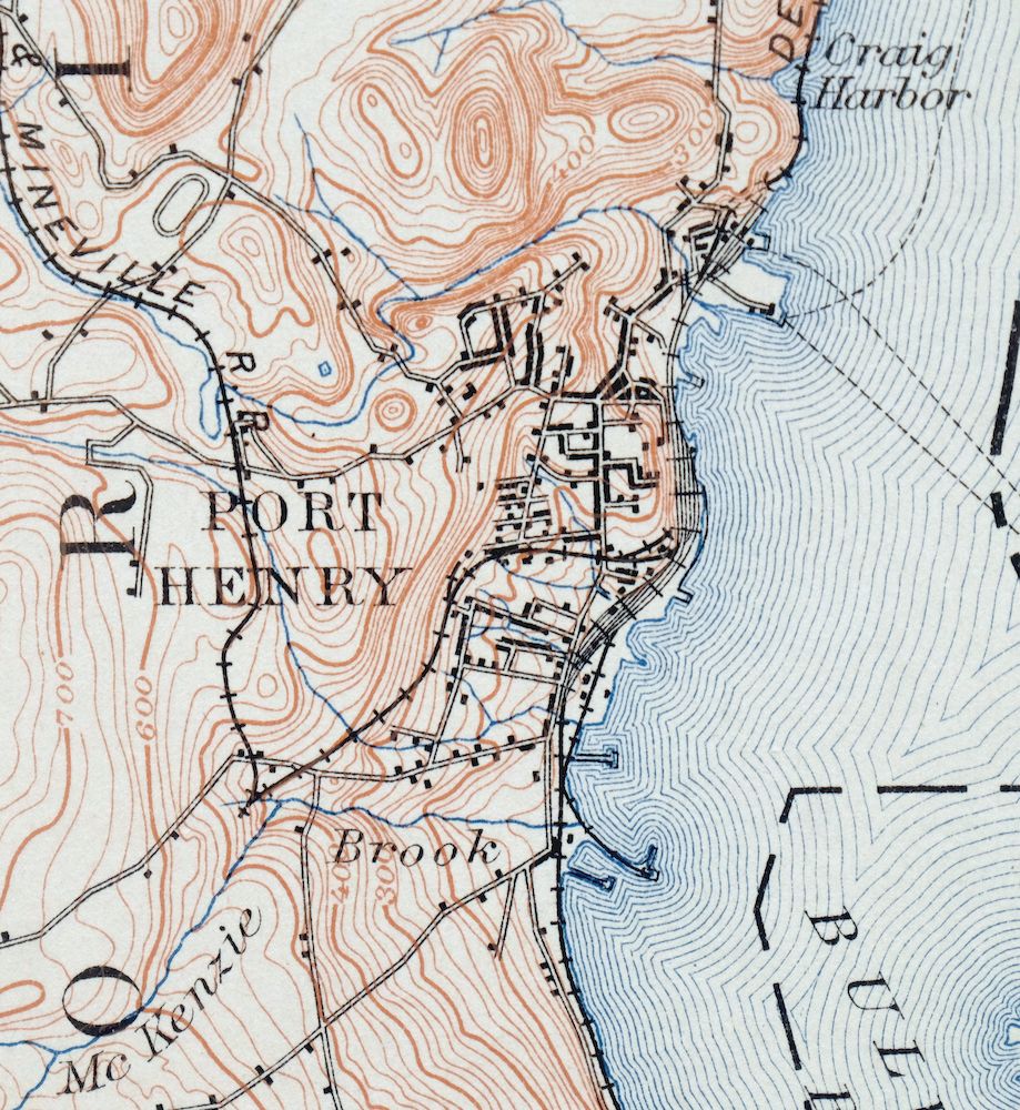
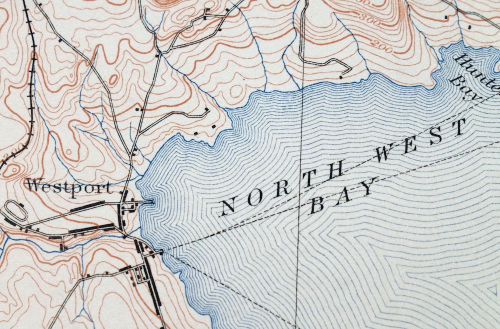
| MAP NOTES | A fascinating historical snapshot of the Lake Champlain area from Split Rock Mountain to Crown Point, surveyed before the modern highway system, showing historic overland travel routes, rail lines, steamboat routes, and early placenames. |
| SHEET CONDITION For maps of this vintage, effort is made to note all visible flaws, no matter how minor. | |
| OVERALL CONDITION | Excellent |
| SHEET NOTES | very lightly handled, never folded, smooth and flat |
| MAP AREA | flawless map area |
| COLLARS | no wear or tears, no markings, minor smudge in bottom collar, hole punches along left collar |
| MAP COVERAGE Quadrangle extent overlaid on current basemap. | |
| BACKSIDE LEGEND | |
 A map summary is printed on the back side of the Port Henry sheet similar to the one shown in the picture. It outlines the history, purpose, and status of the USGS mapping program at the time of the printing in 1913. It also provides instructions on how to read contour lines and a description of how they are used to depict the terrain. At the bottom of the page is a legend showing all of the symbols used to represent the cultural, relief, and water features found on the map. | |
| PLACENAMES Depending on map series and survey date, all of the features listed below may not be shown on this map. This list contains features that currently exist or historically existed within the area covered by the map. The list can be used as a reference to determine if this map covers your area of interest. Placenames are listed alphabetically next to each feature type. | |
| CITIES AND TOWNS (CURRENT) | Mineville-Witherbee, Port Henry, Vergennes, and Westport |
| COUNTIES COVERED | Addison and Essex |
| RIVERS AND STREAMS | Bartlett Brook, Beaver Brook, Boquet River, Crooked Brook, Dead Creek, East Branch Dead Creek, Grove Brook, Hammond Brook, Hoisington Brook, Lemon Fair River, Lewis Creek, Little Otter Creek, McKenzie Brook, Middle Branch Dead Creek, Mill Brook, Mullen Brook, Otter Creek, South Slang Creek, Stacy Brook, Wards Creek, and West Branch Dead Creek |
| WATER BODIES | Lake Champlain |
| Vermont Locations: Basin Harbor Golf Course, Champlain Bridge Marina, Grandview Grange, Griffins Ten Acre Campground, and McCuen Slang Waterfowl Area. Administrative Boundaries: Town of Addison, Town of Ferrisburgh, Town of Panton, and City of Vergennes. Mountains, Peaks, and Summits: Snake Mountain. Parks: Button Bay State Park, Dead Creek Wildlife Management Area, Kings Bay State Park, and Little Otter Creek Wildlife Management Area. Drainages: South Slang Creek, Dead Creek, East Branch Dead Creek, East Slang Creek, Goose Creek, Holcomb Slang Creek, Hospital Creek, Lewis Creek, Little Otter Creek, Middle Branch Dead Creek, Otter Creek, Wards Creek, and West Branch Dead Creek. Islands: Ship Point, Button Island, Diamond Island, Mud Island, and Rock Island. Capes: Summer Point, Crane Point, Elm Point, Fort Cassin Point, Grosse Point, Macdonough Point, Mile Point, Oven Point, and Potash Point. Churches: Saint Peters Catholic Church, Addison Baptist Church, Panton Community Baptist Church, Vergennes Congregational Church, and Vergennes United Methodist Church. Buildings: Bixby Memorial Free Library, Button Bay Nature Center, John Strong DAR Mansion, Lake Champlain Maritime Museum, Vergennes City Hall, and Vergennes Opera House. Dams: Stone Bridge Dam, Brilyea East Dam, Brilyea West Dam, Farrell Dam, Jerome Dam, and Tetrault Dam. Bluffs: Scotch Bonnet. Channels: The Narrows. Bridges: Lake Champlain Toll Bridge. Bays: Spaulding Bay, Arnold Bay, Basin Harbor, Button Bay, Fields Bay, Hawkins Bay, Kingsland Bay, North Harbor, Owls Head Bay, Porter Bay, Potash Bay, and White Bay. Airports: Staton Airport, Basin Harbor Airport, and Yankee Kingdom Airport. Swamps: Cranberry Bog. Schools: Sand Road School, Smith School, Addison Central School, Basin Harbor School, Childs School, Crane School, East Panton School, Gage School, Hawthorn School, Nortontown School, Porterboro School, Pratt School, Vanderhoof School, Webster School, West Panton School, and Willmarth School. | |
| New York Locations: Camp Dudley, Fort Crown Point Ruins, and Fort Saint Frederic Ruins. Administrative Boundaries: Town of Westport. Mountains, Peaks, and Summits: Ainger Hill, Bald Peak, Bart Royce Hill, Burns Mountain, Cheney Mountain, Colligan Hill, Cook Mountain, Coon Mountain, Coot Hill, Harper Mountain, Hoisington Mountain, Kronks Hill, Moore Mountain, Payne Hill, Peach Blow Hill, Phinney Hill, The Pinnacle, Quinn Mountain, Smith Hill, Split Rock Mountain, Stanton Hill, Stockwell Mountain, Sullivan Hill, Toll Gate Hill, Trainor Hill, Twin Hill, Two Top Mountain, and Walton Mountain. Drainages: Beaver Brook, Bartlett Brook, Crooked Brook, Grove Brook, Hammond Brook, Hoisington Brook, Kenney Brook, McKenzie Brook, Mill Brook, Mullen Brook, Stacy Brook, and Stony Brook. Islands: Cole Island and Diamond Island. Capes: Barber Point, Barn Rock, Bluff Point, Coffin Point, Crown Point, Furnace Point, Lapstone Point, Moore Point, and Orchard Point. Lakes and Ponds: Mill Pond and Rogers Pond. Bluffs: Palisades. Channels: The Narrows. Bridges: Lake Champlain Toll Bridge. Bays: Barn Rock Bay, Bulwagga Bay, Cold Spring Bay, Cole Bay, Craig Harbor, Hunter Bay, Louis Clearing Bay, Mullen Bay, North West Bay, Partridge Harbor, Rock Harbor, Snake Den Harbor, South Bay, Stevenson Bay, and Young Bay. Airports: Westport Airport. Swamps: Black Ash Swamp. Schools: Ainger Hill School, Cheever School, French School, and Hoisington School. | |
| SHIPPING AND RETURNS | |
 This map sheet will be carefully rolled in a sturdy tube and shipped via the US Postal Service. If you find that the sheet you receive is not as described in the listing, you may ship it back to us for a refund of the purchase price. | |

Port Henry Vermont Lake Champlain USGS Topo Map 1913 Antique
$115
First published in 1898, this Port Henry sheet was printed in 1913 and survives in excellent condition, never folded, smooth and flat on thick stock. It spans the Vermont–New York line along Lake Champlain, taking in Vergennes on the Vermont side and Port Henry, Mineville-Witherbee, and Westport across the water in New York. Surveyed in 1892 and engraved in 1894 under geographer Henry Gannett, it records the Lake Champlain area from Split Rock Mountain to Crown Point before the modern highway system, showing overland travel routes, rail lines, steamboat routes, and early placenames. The reverse carries printed reference material on reading the map. It comes from an uncommonly well-preserved collection.
In stock
This antique sheet is an 1898 edition of the Port Henry Vermont USGS topographic map. It is an authentic 113-year-old 1913 United States Geological Survey print in excellent condition.
HOW THIS MAP CAN BE USED
In addition to making a fascinating conversation piece, this sheet would look great in a frame or on display, make a unique and prized gift for anyone interested in this area, be perfect as a reference for genealogy studies or general historical research, or fill that missing piece in your collection.
FEATURES SHOWN ON THE MAP
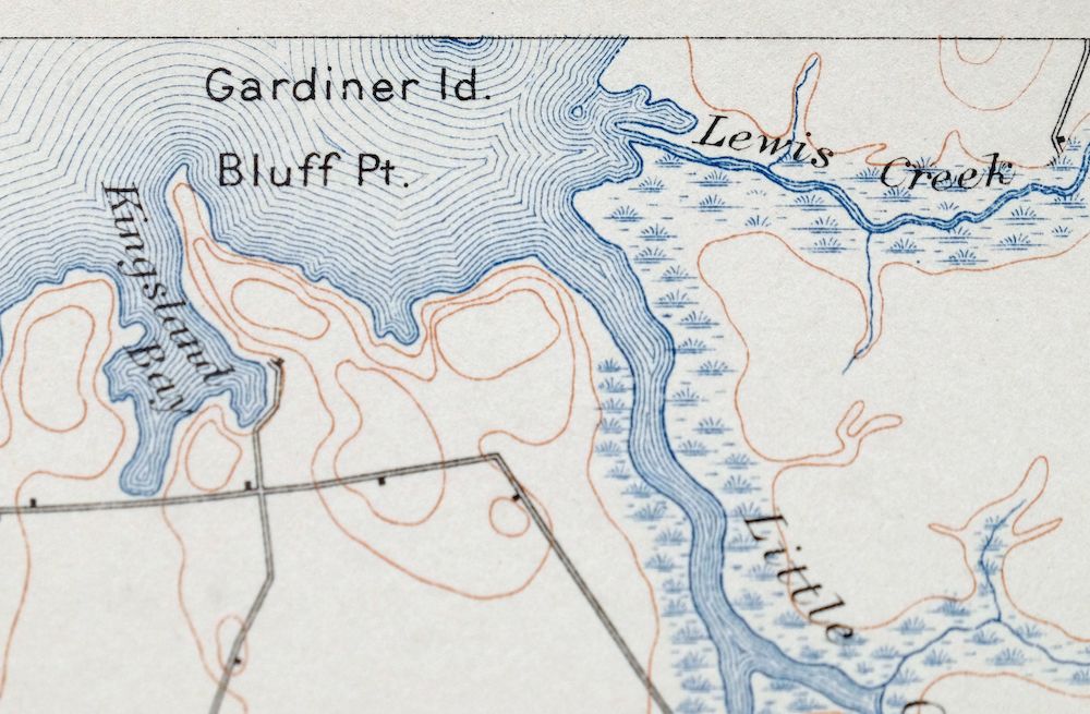
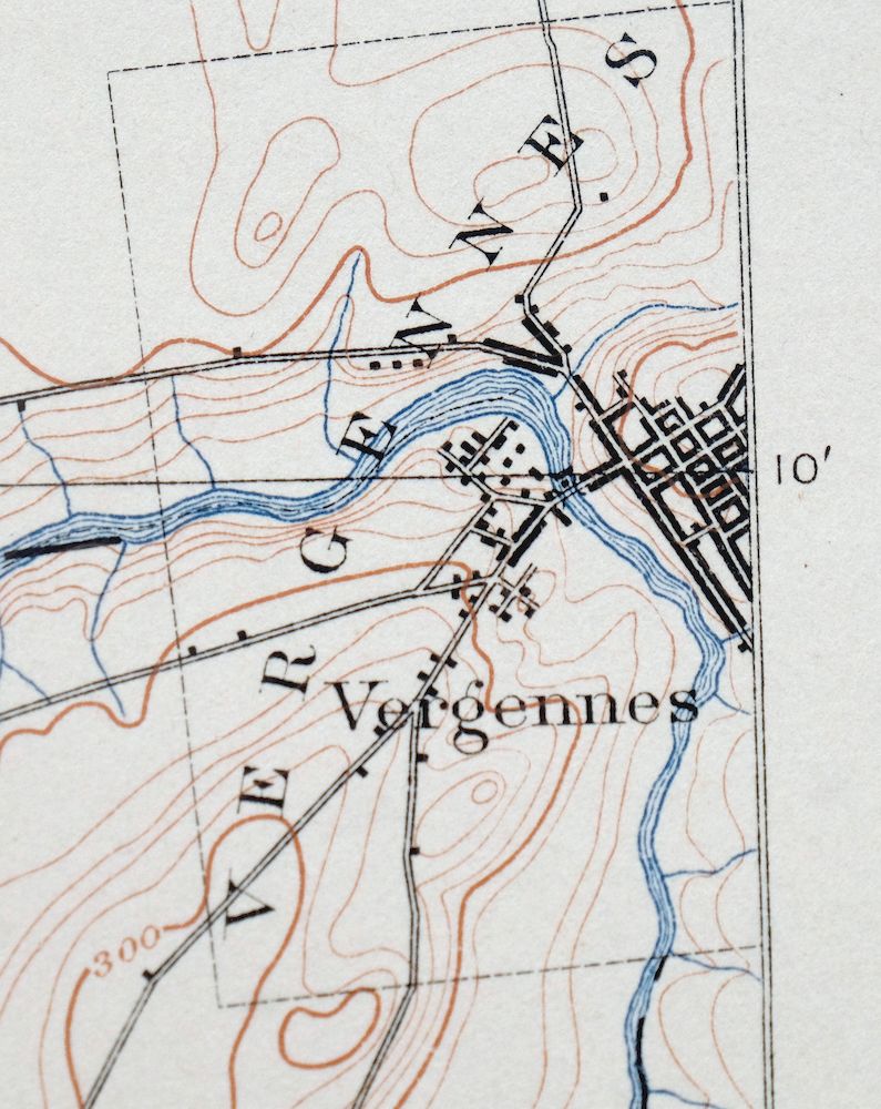
The Port Henry 15-minute map shows cities and towns, roads, railroads, rivers, creeks, elevation contour lines, public land survey lines, county, state, and other administrative boundaries as they existed at the time of the survey in 1892. All known structures (houses, businesses, churches, schools, barns, cabins, etc) are also shown, with exceptions in some urban areas, where only landmark buildings may be shown.
A VALUABLE HISTORICAL RECORD
Maps from the 15-minute series for the continental United States are no longer produced or printed by the USGS and original prints are becoming increasingly difficult to find. They are a valuable historical record for an area, as they contain many placenames and features that have been dropped from more recent maps.
Nearby maps
-

Middlebury Vermont Bristol Starksboro USGS Topo Map 1905
$67 Add to cart -
Ausable New York Au Sable Forks USGS Topo Map 1909 Antique
$48 Add to cart -

Brandon Vermont Green Mountain NF USGS Topo Map 1911 Antique
$52 Add to cart -

Dannemora New York Peru Saranac USGS Topographic Map 1913
$48 Add to cart -

Rouses Point New York Champlain Alburg USGS Topo Map 1913
$58 Add to cart -
Saint Regis New York USGS 15-Min Topo Map 1911 Antique
$95 Add to cart -
Mooers New York West Chazy Altona USGS Topo Map 1912 Antique
$57 Add to cart -
Churubusco New York Lyon Mountain USGS Topo Map 1915 Antique
$48 Add to cart -

Chateaugay New York Burke USGS 15-Min Topo Map 1915 Antique
$46 Add to cart -
Raquette Lake New York Speculator USGS Topo Map 1964 Vintage
$32 Add to cart -
Potsdam New York Norwood Colton USGS Topographic Map 1908
$85 Add to cart -
Old Forge New York USGS 15-Min Topographic Map 1913 Antique
$90 Add to cart -

Massena New York Stockholm Norwood USGS 15-Min Topo Map 1909
$52 Add to cart -
Wilmurt New York USGS 15-Min Topographic Map 1912 Antique
$48 Add to cart -

Canton New York Potsdam Norwood USGS Topo Map 1911 Antique
$49 Add to cart -
Amsterdam New York Rotterdam Hagaman USGS Topo Map 1912
$45 Add to cart -

Taconic Vermont Pittsfield Adams USGS Topographic Map 1912
$79 Add to cart -
Fonda New York Esperance Johnstown USGS 15-Min Topo Map 1909
$52 Add to cart -

Gouverneur New York Edwards Richville USGS Topo Map 1915
$52 Add to cart -

Mount Washington New Hampshire Berlin USGS Topo Map 1967
$42 Add to cart -

Waddington New York Norwood Madrid USGS 15-Min Topo Map 1905
$115 Add to cart -
Lowville New York Indian River Croghan USGS Topo Map 1913
$60 Add to cart -
Little Falls New York Salisbury Herkimer USGS Topo Map 1911
$52 Add to cart -

Troy New York Albany Watervliet USGS Topo Map 1907 Antique
$95 Add to cart