MAP DETAILS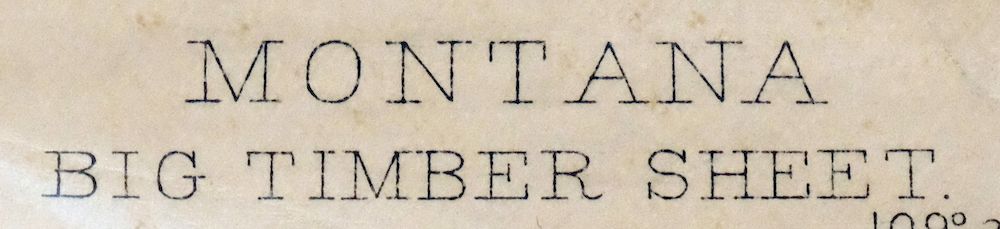 | |
|---|---|
| TITLE | Big Timber |
| STATE | Montana |
| LOCATION | 60 miles west of Billings, MT |
| SERIES | 30-minute |
| SURVEYED | 1889 Field Survey |
| GEOGRAPHER | A.H. Thompson |
| EDITION | 1893 |
| PRINTED | 1910 |
| PRINT NOTES | Thick paper stock |
| SCALE | 1:125000 |
| CONTOUR INTERVAL | 50 feet |
| SHEET DIMENSIONS | 16 1/2 x 20 inches |
| MAP DIMENSIONS | 12 1/4 x 17 1/2 inches |
| COVERAGE AREA | 24 x 35 miles |
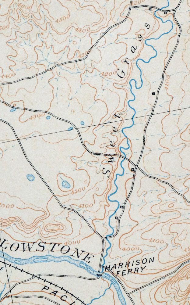
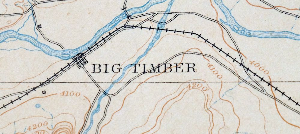
| MAP NOTES | Surveyed long before the existence of Interstate 90, showing historic travel routes, rail lines, and Harrison Ferry. |
| SHEET CONDITION For maps of this vintage, effort is made to note all visible flaws, no matter how minor. | |
| OVERALL CONDITION | Fair |
| SHEET NOTES | moderately handled, never folded, creases in top portion of sheet, evenly age-toned paper |
| MAP AREA | no markings, no blemishes |
| COLLARS | some edge chips and minor tears, edge tears carefully stabilized with transparent archival tape on backside of sheet, pencilled inventory notation in upper right collar corner, minor blemishes and smudges, creases in collar |
 | |
| MAP COVERAGE Quadrangle extent overlaid on current basemap. | |
| BACKSIDE LEGEND | |
 A map summary is printed on the back side of the Big Timber sheet similar to the one shown in the picture. It outlines the history, purpose, and status of the USGS mapping program at the time of the printing in 1910. It also provides instructions on how to read contour lines and a description of how they are used to depict the terrain. At the bottom of the page is a legend showing all of the symbols used to represent the cultural, relief, and water features found on the map. | |
| PLACENAMES Depending on map series and survey date, all of the features listed below may not be shown on this map. This list contains features that currently exist or historically existed within the area covered by the map. The list can be used as a reference to determine if this map covers your area of interest. Placenames are listed alphabetically next to each feature type. | |
| CITIES AND TOWNS (CURRENT) | Big Timber, Greycliff, and Reed Point |
| COUNTIES COVERED | Stillwater and Sweet Grass |
| FEDERAL LAND UNITS | Custer National Forest and Gallatin National Forest |
| RIVERS AND STREAMS | Bad Canyon Creek, Big Timber Creek, Blind Bridger Creek, Boulder River, Bridger Creek, Carson Creek, Chimney Rock Creek, Clause Creek, Cottonwood Creek, Countryman Creek, Cow Creek, Cox Creek, Crazy Man Creek, Davis Creek, Dead Indian Creek, Deadmans Creek, Dry Creek, Dry Fork Sweet Grass Creek, East Fork Sweet Grass Creek, East Fork Upper Deer Creek, East White Beaver Creek, Fletcher Creek, Greycliff Creek, Grove Creek, Hamilton Creek, Hangmans Creek, Hump Creek, Jack Stone Creek, Little Spring Creek, Lodgepole Creek, Log Cabin Creek, Lower Deer Creek, Middle Fork Sweet Grass Creek, Needle Creek, North Fork Countryman Creek, North Fork Sevenmile Creek, Old Daves Creek, Otter Creek, Ryan Creek, Sams Creek, Sandborn Creek, Sectionhouse Creek, Sevenmile Creek, Silver Creek, Sourdough Creek, South Fork Big Coulee Creek, South Fork Countryman Creek, South Fork Tenmile Creek, Spring Creek, Stillwater River, Swamp Creek, Sweet Grass Creek, Tenmile Creek, Tepee Creek, Trout Creek, Upper Deer Creek, West Bridger Creek, West Fork Dry Creek, West Fork Lower Deer Creek, West Fork Upper Deer Creek, West White Beaver Creek, Whistle Creek, White Beaver Creek, Whitetail Creek, Whitney Creek, Wildcat Creek, Work Creek, and Yellowstone River |
| WATER BODIES | Beley Pond, Glass Lindsay Lakes Lower Reservoir, Kent Lake, and Lavold Reservoir |
| Locations: Big Rock Fishing Access Site, Big Timber, Big Timber Industrial Park, Big Timber KOA Campground, Bjorndal Ranch, Boe Ranch, Branae Ranch, Bratten Fishing Access Site, Cedar Hills Campground, Cliff Swallow Fishing Access Site, Cosgriff Ranch, D McCormick Ranch, Eatons Inn, Ellison Ranch, Greycliff, Greycliff Prairie Dog Town, Greycliff Rest Area, Hookum Cow Cabin, Huyser Ranch, Indian Fort Fishing Access Site, J McCormick Ranch, K-W Feed and Grain Elevator, Kortum Ranch, Kremper Ranch, Lavold Ranch, Lien Ranch, Mattice Homestead, Murray Ranch, Nelson Ranch, Otter Creek Fishing Access Site, Overland Golf Course, Pelican Fishing Access Site, Rapelje Grain Company Elevator, Sherod Ranch, Songstad Ranch, Spring Creek Camp and Trout Ranch, Stone Breastwork Indian Battlesite, Sweet Grass County Fairgrounds, Wepler Cabin, West Bridger Station, Yates Cabin, and Yellowstone River Trout Hatchery. Mountains, Peaks, and Summits: Arch Rock, Black Butte, Cow Face Hill, Derby Mountain, Ellis Mountain, Evergreen Mountain, Gold Hill, Hicks Mountain, Iron Mountain, Lone Indian Butte, Madison Grade, Monument Butte, Mud Butte, Packsaddle Butte, Piano Hill, Red Mountain, Sliderock Mountain, Squaw Teats, Stephens Hill, and Sugarloaf Mountain. Valleys and Canyons: Asp Gulch, Baker Canyon, Barney Gulch, Bear Chip Coulee, Bear Gulch, Beartrap Draw, Big Spring Gulch, Boundary Draw, Box Canyon, Breck Gulch, Calcie Gulch, Carey Gulch, Cartwright Gulch, Clark Draw, Clark Gulch, Cudney Draw, Curtis Gulch, Davis Gulch, Dead Horse Gulch, Decker Gulch, Derby Gulch, Dillon Gulch, Dry Draw, Dry Gulch, Elliot Draw, Fahlgren Gulch, Fire Gulch, Fyfe Coulee, Gunnerson Draw, Harris Gulch, Jims Gulch, Lambing Gulch, Lee Gulch, Lien Gulch, Long Draw, Long Gulch, Lundy Draw, McKinsey Draw, Mendenhail Draw, Mexican Gulch, Nash Gulch, New Schoolhouse Gulch, Nicely Gulch, Norman Gulch, North Derby Gulch, Norwegian Gulch, Old Schoolhouse Gulch, Oliver Draw, Overfelt Gulch, Peterson Gulch, Pine Tree Gulch, Placer Gulch, Ross Canyon, Rudd Canyon, Russel Draw, Sawmill Gulch, Scyphers Coulee, Shanks Basin, Slide Rock Gulch, Smith Coulee, Spotts Gulch, Squaw Gulch, Stopher Gulch, Tangen Draw, Tie Cutter Gulch, Tom Benson Gulch, Tomato Can Gulch, Trail Draw, Trail Gulch, West Trail Draw, White Draw, Wildcat Draw, Winge Draw, Wood Gulch, and Wullum Gulch. Parks: Bonanza or Bozeman Trail Historical Marker, Captain William Clark Historical Marker, Crazy Mountains Historical Marker, Greycliff Prairie Dog Town State Park, Lions Club Park, and Thomas Party Historical Marker. Trails: Black Butte Trail, Bozeman Trail, and Lodgepole Trail. Drainages: Big Timber Creek, Blind Bridger Creek, Boulder River, Bridger Creek, Carson Creek, Cedar Creek, Chimney Rock Creek, Clause Creek, Cottonwood Creek, Cow Creek, Cox Creek, Crazy Man Creek, Crest Creek, Davis Creek, Dead Indian Creek, Deadmans Creek, Dry Creek, Dry Fork Sweet Grass Creek, East Bridger Creek, East Fork Sweet Grass Creek, East Fork Upper Deer Creek, Featherbed Creek, Fletcher Creek, Greycliff Creek, Hamilton Creek, Hangmans Creek, Hump Creek, Jack Stone Creek, Little Spring Creek, Log Cabin Creek, Lower Deer Creek, McClain Coulee, Middle Fork Sweet Grass Creek, Milligan Creek, Neddle Creek, Needle Creek, North Fork Countryman Creek, North Fork Sevenmile Creek, Old Daves Creek, Otter Creek, Pig Creek, Ryan Creek, Sams Creek, Sandborn Creek, Sevenmile Creek, Silver Creek, Sixshooter Creek, Sourdough Creek, South Fork Countryman Creek, South Fork Tenmile Creek, Spring Creek, Swamp Creek, Sweet Grass Creek, Tenmile Creek, Tepee Creek, Trout Creek, Upper Deer Creek, West Bridger Creek, West Fork Dry Creek, West Fork Lower Deer Creek, West Fork Upper Deer Creek, Whistle Creek, White Beaver Creek, Whitetail Creek, Wildcat Creek, and Work Creek. Islands: Fire Island. Mines: Crow Mine, Gold Hill Mine, Knapp Mine, Placer Gulch Mine, Ross Mine, Silver King Mine, and Surprise Mine. Churches: Big Timber Baptist Church, Big Timber Church of God, Big Timber Evangelical Free Church, Big Timber Lutheran Church, Church of Christ, Congregational Church, Evangelical Church of North America, Reed Point Lutheran Congregation, Saint Josephs Catholic Church, Saint Marks Episcopal Church, and Seventh Day Adventist Church. Hospitals: Pioneer Nursing Home, Sweet Grass Community Health Clinic, and Sweet Grass Family Medicine Clinic. Lakes and Ponds: Blueball Lake, Kent Lake, and Lower Glaston Lake. Buildings: Big Timber Fire Hall, Big Timber Police Department, Carnegie Public Library, Crazy Mountain Museum, Sweet Grass County Courthouse, Sweet Grass County Sheriffs Office, and Victorian Village Museum. Dams: Beley Pond Dam, Big Timber Sewage Lagoon Dam, Cain Dam, Dry Yellow Grass Dam, Gods Country Number 1 Dam, Holzhey Dam, Lavold Dam, Papez Number 1 Dam, Papez Number 2 Dam, Pioneer Dam, Rosann Rosanna Dana Dam, and Smoky Dam. Crossings: Interchange 367, Interchange 370, Interchange 377, Interchange 384, and Interchange 392. Bluffs: The Greycliffs. Canals: Arneson Ditch, Arthun Ditch, Auwater Ditch, Bailey-Clark Ditch, Big Timber Creek Canal, Boggs Ditch, Brey Riddle Ditch, Clause Weaver Ditch, Clayton Ditch, Conwell Ditch, Crest Ditch, Dry Creek Ditch, Electric Light Ditch, Elis-King-Hawks Ditch, Ellison Ditch, Esp Ditch, Harrison Ditch, Hawks Ditch, Hogan Ditch, Huidekoper-Warp-McComb Ditch, Kent Ditch, Krone Ditch, Lamp-Nelson Ditch, Larson-Johnson Ditch, Line Ditch, Mauland Rapstad Ditch, Mauland-Westervelt Ditch, Meyers-Rapstad-Rudd Ditch, Phelps Ditch, Pioneer Ditch, Post-Kellogg Ditch, Reed Point Ditch, Rudd Ditch, Stillwater Ditch, Tenmile Ditch, Tintinger Ditch, and Weir-Crawford Ditch. Bridges: Eightmile Bridge, Greycliff Bridge, Old Boulder Bridge, and Reedpoint Bridge. Airports: Big Timber Airport. Swamps: Milliken Sloughs. Schools: Big Timber School, Greycliff School, Reedpoint Elementary School, Reedpoint High School, and Sweet Grass County High School. Ridges: Derby Ridge, Fire Ridge, and Grouse Ridge. Reservoirs and Tanks: Beley Pond, First Creek Reservoir, and Lavold Reservoir. Flats: McKenzie Flats. Wells: 01N14E10____01 Well, 01N14E11ACAA01 Well, 01N14E11____01 Well, 01N14E12CACB01 Well, 01N14E12CCAD01 Well, 01N14E12____01 Well, 01N14E13BBCD01 Well, 01N14E13BDCA01 Well, 01N14E13DAAC01 Well, 01N14E13DABD01 Well, 01N14E15BDBB01 Well, 01N14E15BDCB01 Well, 01N14E15DAAB01 Well, 01N14E21AADC01 Well, 01N14E21DCDC01 Well, 01N14E23BDAB01 Well, 01N14E23BDAD01 Well, 01N14E23DBAC01 Well, 01N14E23____01 Well, 01N14E24AAAA01 Well, 01N14E24BBCD01 Well, 01N14E26DAAC01 Well, 01N14E27DDCB01 Well, 01N14E28BABD01 Well, 01N14E34ABDD01 Well, 01N14E34ADAB01 Well, 01N14E34ADDC01 Well, 01N15E07C___01 Well, 01N15E10DBBD01 Well, 01N15E12C___01 Well, 01N15E20B___01 Well, 01N15E21ADAC01 Well, 01N15E21BADA01 Well, 01N15E21DBBC01 Well, 01N15E29C___01 Well, 01N15E29DCAD01 Well, 01N15E31____01 Well, 01N15E33ABBC01 Well, 01N15E33ABBC02 Well, 01N16E08ADAA01 Well, 01N16E08____01 Well, 01N16E10BDBD01 Well, 01N16E17____01 Well, 01N16E31____01 Well, 01N17E25C___01 Well, 01N18E33CCDC01 Well, 01S14E02BAAA01 Well, 01S14E03BDBB01 Well, 01S14E10ADBB01 Well, 01S14E10BBCD01 Well, 01S14E10CAAD01 Well, 01S14E10CABD01 Well, 01S14E10CCAD01 Well, 01S14E15BBCC01 Well, 01S14E21AABB01 Well, 01S14E21AADD01 Well, 01S14E21ACAD01 Well, 01S14E28AAAD01 Well, 01S14E28ABBD01 Well, 01S15E01DAAC01 Well, 01S15E02ABBA01 Well, 01S15E04ABCD01 Well, 01S15E06ADCA01 Well, 01S15E06A___01 Well, 01S15E22ABCC01 Well, 01S16E05____01 Well, 01S16E08BCBB01 Well, 01S16E08BDDB01 Well, 01S16E08____01 Well, 01S16E17DCBA01 Well, 01S16E22CBBA01 Well, 01S16E24AACC01 Well, 01S16E25AAAC01 Well, 01S16E25____01 Well, 01S16E36CBDA01 Well, 01S17E02ABCD01 Well, 01S17E19BDCD01 Well, 01S17E20CBAA01 Well, 01S17E20CBAD01 Well, 01S17E20CBAD02 Well, 01S17E24BCAA01 Well, 01S17E29BDDD01 Well, 01S17E33DACB01 Well, 01S17E35ABAB01 Well, 01S17E36AACD01 Well, 01S18E18CCBA01 Well, 01S18E30CCAD01 Well, 01S18E31ADCC01 Well, 01S18E36DCDB01 Well, 02N14E15CBCA01 Well, 02N14E15____01 Well, 02N14E16____01 Well, 02N14E22C___01 Well, 02N14E22____01 Well, 02N14E34A___01 Well, 02N15E05D___01 Well, 02N15E06____01 Well, 02N15E08CAAC01 Well, 02N15E18____01 Well, 02N15E23A___01 Well, 02N15E23BACC01 Well, 02N15E27____01 Well, 02N16E02____01 Well, 02N16E28____01 Well, 02N18E06AACA01 Well, 02S16E10BACD01 Well, 02S16E12DCBA01 Well, 02S17E11ADAD01 Well, 02S17E11ADBA01 Well, 02S17E22AACB01 Well, 03N14E24____01 Well, 03N15E21____01 Well, 03N15E27DBBD01 Well, 03N16E35DBAD01 Well, 03S16E09DACC01 Well, 03S18E33BDAB01 Well, and 04S17E08BDDA01 Well. Springs: 01N14E15DAAA01 Spring, 01N14E23ACDD01 Spring, 01N14E24BBBA01 Spring, 01N14E34BDBA01 Spring, 01S14E03BCAB01 Spring, 01S14E11BBBD01 Spring, 01S15E14BBBC01 Spring, 01S15E22ACCC01 Spring, 01S16E22CBBC01 Spring, 02S15E03ABBA01 Spring, 02S16E20ACCA01 Spring, 02S17E09BDAC01 Spring, 02S17E15DCAC01 Spring, 02S17E15DCDC01 Spring, Boundary Draw Spring, Dahl Spring, Dead Indian Spring, McKinsey Spring, Porcupine Spring, Ross Spring, September Morn Spring, Tepee Spring, West Trail Draw Spring, White Spring, Wildcat Spring Number One, and Wildcat Spring Number Two. | |
| SHIPPING AND RETURNS | |
 This map sheet will be carefully rolled in a sturdy tube and shipped via the US Postal Service. If you find that the sheet you receive is not as described in the listing, you may ship it back to us for a refund of the purchase price. | |

Big Timber Montana Reed Point Reed Point USGS Topo Map 1910
$48
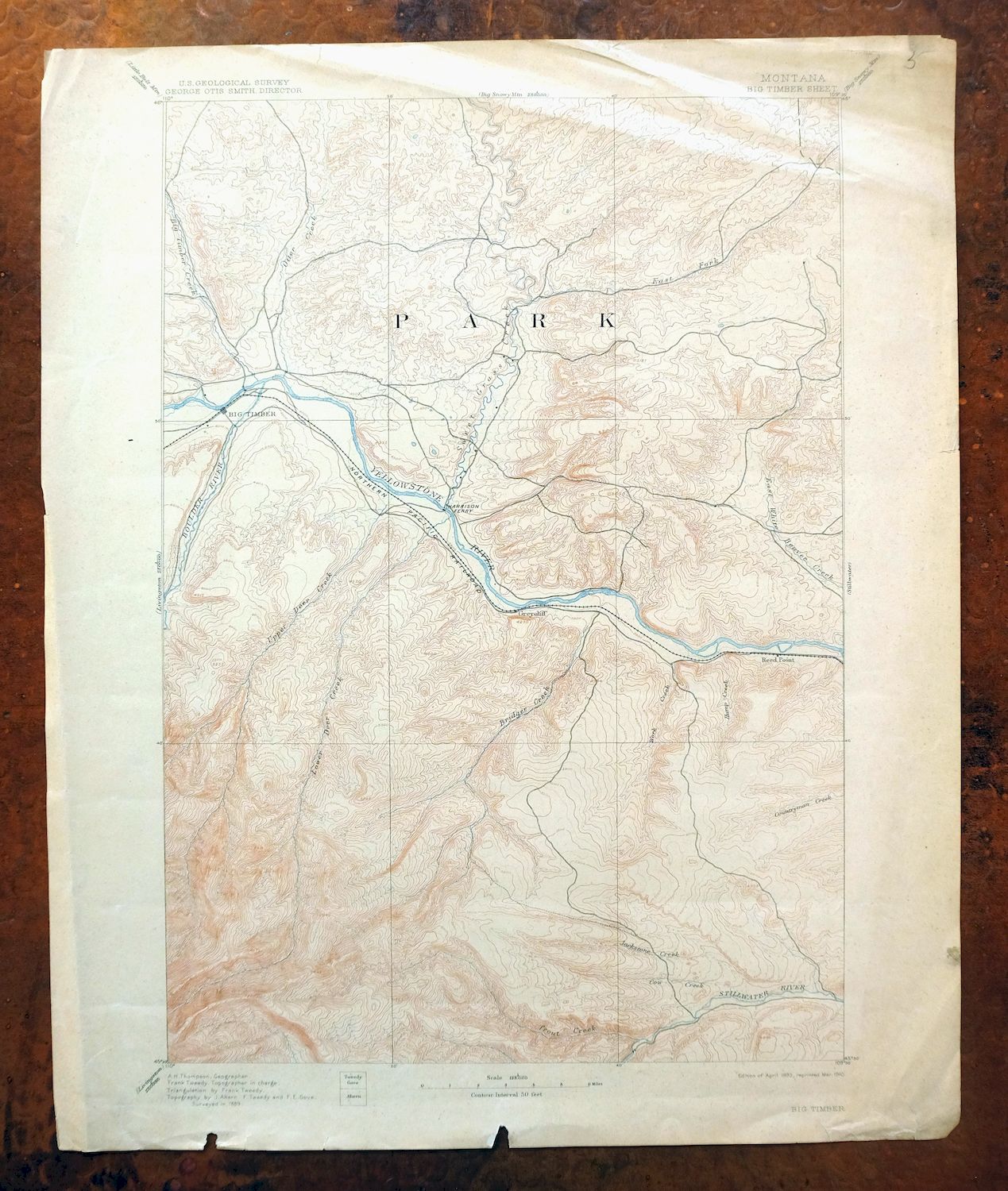
This USGS 30-minute topographic sheet is a first-published 1893 edition, printed in 1910 on thick stock, and the antique paper survives in fair condition — moderately handled, never folded, with even age-toning and creases in the top portion. Sixty miles west of Billings, the quad takes in Big Timber along the Yellowstone River in Stillwater and Sweet Grass counties, with the communities of Reed Point and Greycliff falling within its boundaries and portions of the Gallatin and Custer national forests along the way. Surveyed in 1889, long before Interstate 90, it records the older network of travel routes, rail lines, and Harrison Ferry that once carried movement through the valley, and the reverse carries printed reference material on reading the map.
In stock
This antique sheet is an 1893 edition of the Big Timber Montana USGS topographic map. It is an authentic 116-year-old 1910 United States Geological Survey print in fair condition.
HOW THIS MAP CAN BE USED
In addition to making a fascinating conversation piece, this sheet would make a unique and prized gift for anyone interested in this area, be perfect as a reference for genealogy studies or general historical research, or fill that missing piece in your collection.
FEATURES SHOWN ON THE MAP
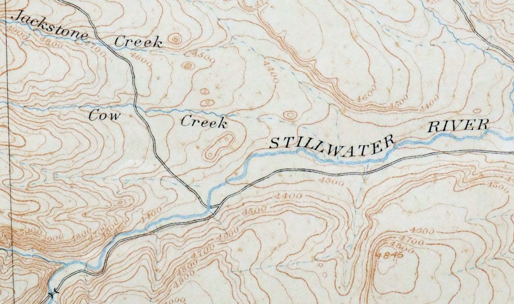
The Big Timber 30-minute map shows cities and towns, roads, railroads, rivers, creeks, elevation contour lines, public land survey lines, county, state, and other administrative boundaries as they existed at the time of the survey in 1889.
A VALUABLE HISTORICAL RECORD
Maps from the USGS 30-minute series have been out of print for many years. They have never been common and original prints are increasingly difficult to find. For areas where the 30-minute map was produced, it is usually the first large-scale survey done by the USGS for that area. These are a valuable historical record, as they contain many placenames and features that have been dropped from more recent series’ and editions.
Nearby maps
-
Stillwater Montana Hailstone NWR Columbus USGS Topo Map 1932
$47 Add to cart -
Lake Wyoming Antique USGS Topographic Map 1922
$78 Add to cart -

Boulder Montana Butte-Silver Bow Clancy USGS Topo Map 1933
$39 Add to cart -

Mount Cowen Montana Absaroka Range USGS 15-Min Topo Map 1963
$43 Add to cart -

Sedan Montana USGS 15-Min Topographic Map 1956 Vintage
$38 Add to cart -
Bozeman Pass Montana USGS 15-Min Topo Map 1978 Vintage
$42 Add to cart -
Fridley Peak Montana USGS 15-Min Topo Map 1972 Vintage
$50 Add to cart -

Tower Junction Wyoming USGS 15-Min Topo Map 1984 Vintage
$40 Add to cart -

Miner Montana Gardiner Corwin Springs USGS Topo Map 1983
$36 Add to cart -

Sunlight Peak Wyoming Pahaska Tepee USGS Topo Map 1980
$36 Add to cart -

Crown Butte Montana Yellowstone NP USGS 15-Min Topo Map 1979
$40 Add to cart -

Mount Holmes Wyoming USGS 15-Min Topo Map 1979 Vintage
$39 Add to cart -

Spanish Peaks Montana Big Sky USGS Topo Map 1973 Vintage
$37 Add to cart -
Cody Wyoming USGS 15-Min Topographic Map 1969 Vintage
$38 Add to cart -
Sphinx Mountain Montana Big Sky USGS Topo Map 1968 Vintage
$40 Add to cart -

Tepee Creek Montana Grayling USGS Topo Map 1963 Vintage
$35 Add to cart -

Ennis Montana McAllister Jeffers USGS Topo Map 1969 Vintage
$38 Add to cart -
Lewistown Montana Judith Mountains USGS 15-Min Topo Map 1975
$40 Add to cart -
Judith Peak Montana Black Butte USGS Topo Map 1978 Vintage
$38 Add to cart -

Devils Fence Montana USGS 15-Min Topo Map 1950 Vintage
$36 Add to cart -

East Helena Montana Helena Clancy USGS Topographic Map 1974
$42 Add to cart -
Monument Ridge Montana USGS 15-Min Topo Map 1975 Vintage
$38 Add to cart -

Jefferson City Montana Clancy Basin USGS Topo Map 1967
$39 Add to cart -
Fairfield Montana Simms Fort Shaw USGS Topo Map 1952 Vintage
$45 Add to cart
