MAP DETAILS | |
|---|---|
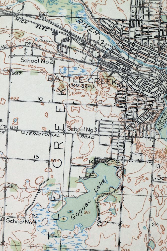
| TITLE | Battle Creek |
| STATE | Michigan |
| LOCATION | 50 miles southeast of Grand Rapids |
| SERIES | 15-minute |
| SURVEYED | 1917 Field Survey |
| GEOGRAPHER | R.B. Marshall |
| EDITION | 1918 |
| PRINTED | 1918 |
| SCALE | 1:62500 |
| CONTOUR INTERVAL | 20 feet |
| SHEET DIMENSIONS | 16 1/2 x 20 inches (approximate) |
| MAP DIMENSIONS | 12 7/8 x 17 1/2 inches |
| COVERAGE AREA | 13 x 17 miles |
| SHEET CONDITION For maps of this vintage, effort is made to note all visible flaws, no matter how minor. | |
| OVERALL CONDITION | Excellent |
| SHEET NOTES | lightly handled, never folded, lightly age-toned sheet |
| MAP AREA | no wear, no markings, no blemishes, flawless map area |
| COLLARS | no wear or tears, no markings, no blemishes |
| MAP COVERAGE Quadrangle extent overlaid on current basemap. | |
| BACKSIDE LEGEND | |
 A map summary is printed on the back side of the Battle Creek sheet similar to the one shown in the picture. It outlines the history, purpose, and status of the USGS mapping program at the time of the printing in 1918. It also provides instructions on how to read contour lines and a description of how they are used to depict the terrain. At the bottom of the page is a legend showing all of the symbols used to represent the cultural, relief, and water features found on the map. | |
| PLACENAMES Depending on map series and survey date, all of the features listed below may not be shown on this map. This list contains features that currently exist or historically existed within the area covered by the map. The list can be used as a reference to determine if this map covers your area of interest. Placenames are listed alphabetically next to each feature type. | |
| CITIES AND TOWNS (CURRENT) | Battle Creek, Bellevue, Brownlee Park, Level Park-Oak Park, and Springfield |
| COUNTIES COVERED | Barry, Calhoun, and Eaton |
| RIVERS AND STREAMS | Ackley Creek, Barnum Creek, Battle Creek, Brickyard Creek, Crooked Brook, Dickinson Creek, Ellis Creek, Harper Creek, High Bank Creek, Kalamazoo River, Lacey Creek, Minges Brook, Mud Creek, Pigeon Creek, Spring Brook, Wabascon Creek, Wanadoga Creek, and Willow Creek |
| WATER BODIES | Beadle Lake, Bear Lake, Bristol Lake, Cassidy Lake, Clear Lake, Cole Lake, Culver Lake, Deep Lake, Dexter Lake, Dunn Lake, Foster Lake, Goguac Lake, Grass Lake, Hall Lake, Hamlin Lake, High Hill Lake, Long Lake, Loon Lake, Lower Mill Pond, Metcalf Lake, Mud Lake, Pine Lake, Saint Marys Lake, Spring Lakes, Von Syckle Lake, Wabascon Lake, West Lake, Wiegands Lake, Wilkes Lake, Willis Lake, and Wolf Lake |
| Locations: Agnew Corners, Battle Creek Country Club, Burleigh Corners, Fruin Corners, Marywood Country Club, Moores Corners, and Riverside Country Club. Administrative Boundaries: Township of Assyria, City of Battle Creek, Township of Bedford, Township of Bellevue, Township of Emmett, Township of Marshall, Township of Pennfield, and City of Springfield. Parks: Bailey Park, Barnes Park, Fell Park, Irving Park, Kellogg Biological Preserve, Kolb Park, Leila Arboretum, McCrae Park, Piper Park, Post Park, Watsh Field, and Willard Park. Drainages: Ackley Creek, Barnum Creek, Battle Creek, Brickyard Creek, Crooked Brook, Crooked Creek, Dickinson Creek, Ellis Creek, Harper Creek, Minges Brook, Mud Creek, Pigeon Creek, Wanadoga Creek, and Willow Creek. Islands: Clark Island, Vince Island, and Ward Island. Churches: Base Line Church, Bethel Chapel, Community Church, and Union Church. Hospitals: Community Hospital, Kimball Sanitorium, and Leila Hospital. Lakes and Ponds: Beadle Lake, Bear Lake, Brigham Lake, Bristol Lake, Cassidy Lake, Clear Lake, Cole Lake, Culver Lake, Deep Lake, Dexter Lake, Dunn Lake, Foster Lake, Gardner Lake, Goguac Lake, Goose Lake, Grass Lake, Hall Lake, Hamlin Lake, High Hill Lake, Little Goose Lake, Long Lake, Loon Lake, Lost Lake, Lower Mill Pond, Metcalf Lake, Mud Lake, Pine Lake, Saint Marys Lake, Spring Lakes, Thomas Lake, Von Syckle Lake, Wabascon Lake, West Lake, Wiegands Lake, Wilkes Lake, Willis Lake, and Wolf Lake. Buildings: Federal Center and Kingman Museum. Canals: Romans Drain. Airports: Leila Hospital Helistop. Swamps: Black Marsh and Cleveland Lake. Schools: Ann Kellogg School, Battle Creek Academy, Battle Creek Public Farm School, Beadle Lake School, Boughton School, Central High School, Checkered School, Cleveland School, Cobblestone School, Conley School, Culver School, Dudley School, Franklin School, Fremont School, Harper Creek School, Kellogg Community College, Kellogg Junior High School, La Mora School, Lakeview High School, Lakeview School, Lincoln School, Lockwood School, Mamby School, McKinley School, Minges Brook School, Monroe School, Newbre School, Newman School, North Pennfield School, Northwest Junior High School, Pennfield School, Pleasantview School, Poorman School, Post School, Poulsen School, Prairieview School, Raymound School, Red Brick School, Riverside School, Roosevelt School, Saint Joseph School, Sandford School, Sandstone School, School Number 2, South West Junior High School, Southeast Junior High School, Springfield School, Territorial School, Urbandale School, Valley View School, Washington School, Westlake School, Wilson School, and Woodrow Junior High School. Towers: WBCK-AM (Battle Creek), WBXX-FM (Battle Creek), WELL-AM (Battle Creek), and WOLY-AM (Battle Creek). | |
| SHIPPING AND RETURNS | |
 This map sheet will be carefully rolled in a sturdy tube and shipped via the US Postal Service. If you find that the sheet you receive is not as described in the listing, you may ship it back to us for a refund of the purchase price. | |
Battle Creek Michigan Springfield USGS Topo Map 1918 Antique
$40
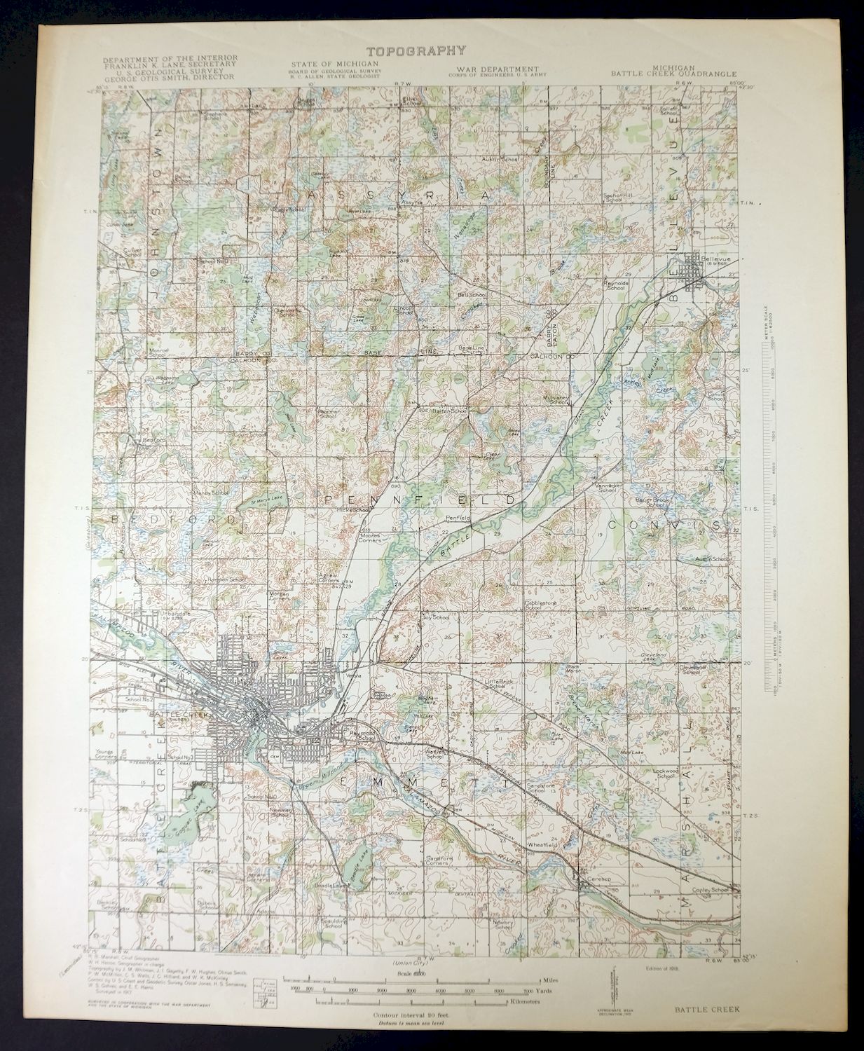
Printed in its year of first publication, 1918, this USGS 15-minute topographic sheet is in excellent condition—a lightly handled, never-folded sheet with light age-toning and a flawless map area. It takes in Battle Creek and surrounding communities including Springfield, Level Park-Oak Park, and Brownlee Park, spanning parts of Calhoun, Barry, and Eaton counties in south-central Michigan. Drawn from a 1917 field survey under geographer R.B. Marshall, it shows the Battle Creek area as it stood in the years when the city was becoming a center of the American breakfast-cereal industry, with printed reference material on the reverse.
In stock
This antique sheet is a 1918 edition of the Battle Creek Michigan USGS topographic map. It is an authentic 108-year-old United States Geological Survey print in excellent condition.
HOW THIS MAP CAN BE USED
In addition to making a fascinating conversation piece, this sheet would look great in a frame or on display, make a unique and prized gift for anyone interested in this area, be perfect as a reference for genealogy studies or general historical research, or fill that missing piece in your collection.
FEATURES SHOWN ON THE MAP
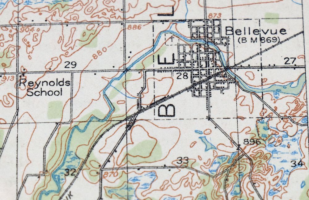
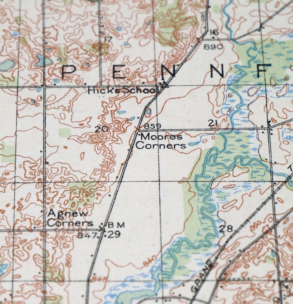
The Battle Creek 15-minute map shows cities and towns, roads, railroads, rivers, creeks, elevation contour lines, public land survey lines, county, state, and other administrative boundaries as they existed at the time of the survey in 1917. All known structures (houses, businesses, churches, schools, barns, cabins, etc) are also shown, with exceptions in some urban areas, where only landmark buildings may be shown.
A VALUABLE HISTORICAL RECORD
Maps from the 15-minute series for the continental United States are no longer produced or printed by the USGS and original prints are becoming increasingly difficult to find. They are a valuable historical record for an area, as they contain many placenames and features that have been dropped from more recent maps.
Nearby maps
-
Corunna Michigan Owosso Durand USGS Topo Map 1929 Antique
$38 Add to cart -
Romulus Michigan Taylor Woodhaven USGS Topo Map 1926 Antique
$35 Add to cart -
Saginaw Michigan Shiawassee NWR Zilwaukee USGS Topo Map 1919
$45 Add to cart -
Jackson Park Illinois Chicago USGS Topo Map 1973 Vintage
$36 Add to cart -
Evanston Illinois Chicago USGS 7.5-Min Topo Map 1964 Vintage
$31 Add to cart -
Lake Calumet Illinois Chicago Hammond USGS Topo Map 1966
$35 Add to cart -
Calumet City Illinois Harvey USGS Topographic Map 1970
$45 Add to cart -
Blue Island Illinois Chicago Posen USGS Topographic Map 1965
$28 Add to cart -
Harvey Illinois Chicago Heights Dolton USGS Topo Map 1965
$46 Add to cart -
Oconomowoc Wisconsin Waukesha Plat USGS Topographic Map 1947
$26 Add to cart -
Dayton Ohio Beavercreek Fairborn USGS Topographic Map 1956
$42 Add to cart -

South Charleston Ohio Springfield Catawba USGS Topo Map 1927
$50 Add to cart -

Shopiere Wisconsin Janesville Clinton USGS Topo Map 1910
$38 Add to cart -
Xenia Ohio Cedarville Jamestown USGS Topographic Map 1934
$43 Add to cart -

Octa Ohio Sabina Jamestown USGS 15-Min Topo Map 1916 Antique
$46 Add to cart -
Mount Sterling Ohio Washington Midway USGS Topo Map 1925
$42 Add to cart -

Madison Ohio North Madison North Perry USGS Topo Map 1985
$44 Add to cart -

Era Ohio South Bloomfield Williamsport USGS Topo Map 1913
$40 Add to cart -

Brodhead Wisconsin Orfordville Albany USGS Topo Map 1910
$80 Add to cart -
Evansville Wisconsin Madison Fitchburg USGS Topo Map 1925
$43 Add to cart -
Sabina Ohio Leesburg New Vienna USGS Topo Map 1917 Antique
$42 Add to cart -
Forreston Illinois Freeport Shannon USGS Topo Map 1972
$14 Add to cart -

Cross Plains Wisconsin Madison Middleton USGS Topo Map 1942
$25 Add to cart -
Conneaut Ohio Hatch Corners USGS Topo Map 1971 Vintage
$44 Add to cart