MAP DETAILS | |
|---|---|
| TITLE | Santaquin |
| STATE | Utah |
| LOCATION | 30 miles southwest of Provo |
| SERIES | 15-minute |
| SURVEYED | 1947 and 1951 Aerial and Field Survey |
| EDITION | 1951 |
| PRINTED | 1971 |
| PRINT NOTES | Thick paper stock, includes woodland tint (green to indicate vegetated areas). A reddish tint is used to indicate urban areas where only landmark buildings are shown. |
| SCALE | 1:62500 |
| CONTOUR INTERVAL | 40 feet |
| SHEET DIMENSIONS | 18 x 22 inches |
| MAP DIMENSIONS | 13 3/8 x 17 1/2 inches |
| COVERAGE AREA | 13 x 17 miles |
| SHEET CONDITION For maps of this vintage, effort is made to note all visible flaws, no matter how minor. | |
| OVERALL CONDITION | Excellent |
| SHEET NOTES | very lightly handled, never folded, smooth and flat |
| MAP AREA | flawless map area |
| COLLARS | no markings, no blemishes, very slight edgewear in top collar |
| MAP COVERAGE Quadrangle extent overlaid on current basemap. | |
| PLACENAMES Depending on map series and survey date, all of the features listed below may not be shown on this map. This list contains features that currently exist or historically existed within the area covered by the map. The list can be used as a reference to determine if this map covers your area of interest. Placenames are listed alphabetically next to each feature type. | |
| NOTABLE PLACES | Mona, Goshen, Wasatch Range, and Juab Valley |
| CITIES AND TOWNS (CURRENT) | Elberta, Genola, Rocky Ridge, Santaquin, and Spring Lake |
| COUNTIES COVERED | Juab and Utah |
| FEDERAL LAND UNITS | Mount Nebo Wilderness and Uinta National Forest |
| RIVERS AND STREAMS | Andrews Creek, Currant Creek, Kimball Creek, Mendenhall Creek, and West Creek |
| WATER BODIES | Burriston Ponds, Ewell Regulating Reservoir, Goshen Reservoir, Mona Reservoir, Santaquin Debris Basin Reservoir, and Summit Creek Number Two Reservoir |
| Populated Place: Rocky Ridge, Genola, Goshen, Lant, Mona, Mount Nebo, Santaquin, Starr, and Townsend. Locations: Bountiful Peak Picnic Area, Starr 8, and Trumbolt Picnic Area. Administrative Boundaries: City of Mona, City of Santaquin, Goshen Division, Town of Goshen, and Town of Rocky Ridge. Mountain Ranges: Wasatch Range. Reserves: Mount Nebo Wilderness. Mountains, Peaks, and Summits: Bald Mountain, Goshen Hill, Mount Nebo, and Warm Springs Mountain. Valleys and Canyons: Alcorns Canyon, Bear Canyon, Black Hollow, Broad Canyon, Cedar Hollow, Cottonwood Canyon, Couch Canyon, Crooked Canyon, Dry Canyon, First Canyon, Goosenest Canyon, Goshen Canyon, Government Canyon, Ingram Canyon, John Jones Canyon, Left Fork Old Canyon, Little Valley, Long Canyon, Long Ridge Canyon, Old Canyon, Pass Canyon, Platt Slide, Pole Canyon, Right Fork Old Canyon, Santaquin Canyon, Slate Jack Canyon, Spring Canyon, Wash Canyon, Water Hollow, Wide Canyon, and Wildcat Gulch. Parks: Mona Front Wildlife Management Area. Trails: Willow Trail. Drainages: Birch Creek, Currant Creek, Gibson Creek, Kimball Creek, Left Fork Willow Creek, Little Birch Creek, Mendenhall Creek, Mona Creek, North Creek, Right Fork Willow Creek, Summit Creek, West Creek, and Willow Creek. Mines: Privateer Mine. Churches: Santaquin Baptist Church, Calvary Chapel Assembly of God Church, and The Church of Jesus Christ of Latter Day Saints. Post Office: Elberta Post Office, Mona Post Office, Goshen Post Office, and Santaquin Post Office. Lakes and Ponds: Burriston Ponds. Buildings: Goshen Fire Department, Mona Fire Department, Rocky Ridge Fire Department, Santaquin City Ambulance, Santaquin Fire Department, and Santaquin Police Department. Dams: Ewell Dam, Mona Dam, Santaquin Debris Basin Dam, and Summit Creek Number Two Dam. Gaps: Wolf Pass. Canals: City Ditch, Currant Creek Canal, East Warm Creek Ditch, and Warm Springs Ditch. Basins: North Basin, Pole Canyon Basin, and South Basin. Census: Elberta Census Designated Place. Schools: C S Lewis Academy, Goshen Elementary School, Mona Elementary School, and Santaquin Elementary School. Ridges: Cedar Ridge, Long Ridge, and Middle Ridge. Reservoirs and Tanks: Ewell Regulating Reservoir, Goshen Reservoir, Mona Reservoir, Santaquin Debris Basin Reservoir, and Summit Creek Number Two Reservoir. Flats: Government Flat and West Park. Springs: Cottonwood Spring, Lunt-Lattimer Spring, Slate Jack Spring, and Warm Springs. Cemetery: Swasey Family Cemetery, Genola Cemetery, Rocky Ridge Cemetery, Goshen Cemetery, Mona Cemetery, Pioneer Memorial Park, and Santaquin City Cemetery. | |
| SHIPPING AND RETURNS | |
 This map sheet will be carefully rolled in a sturdy tube and shipped via the US Postal Service. If you find that the sheet you receive is not as described in the listing, you may ship it back to us for a refund of the purchase price. | |
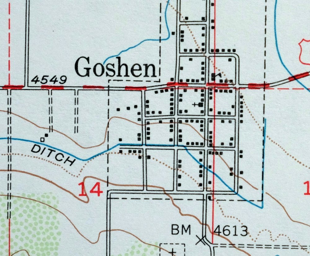

1971 Santaquin Utah USGS Topo Map: Mona (1951 Edition)
$42
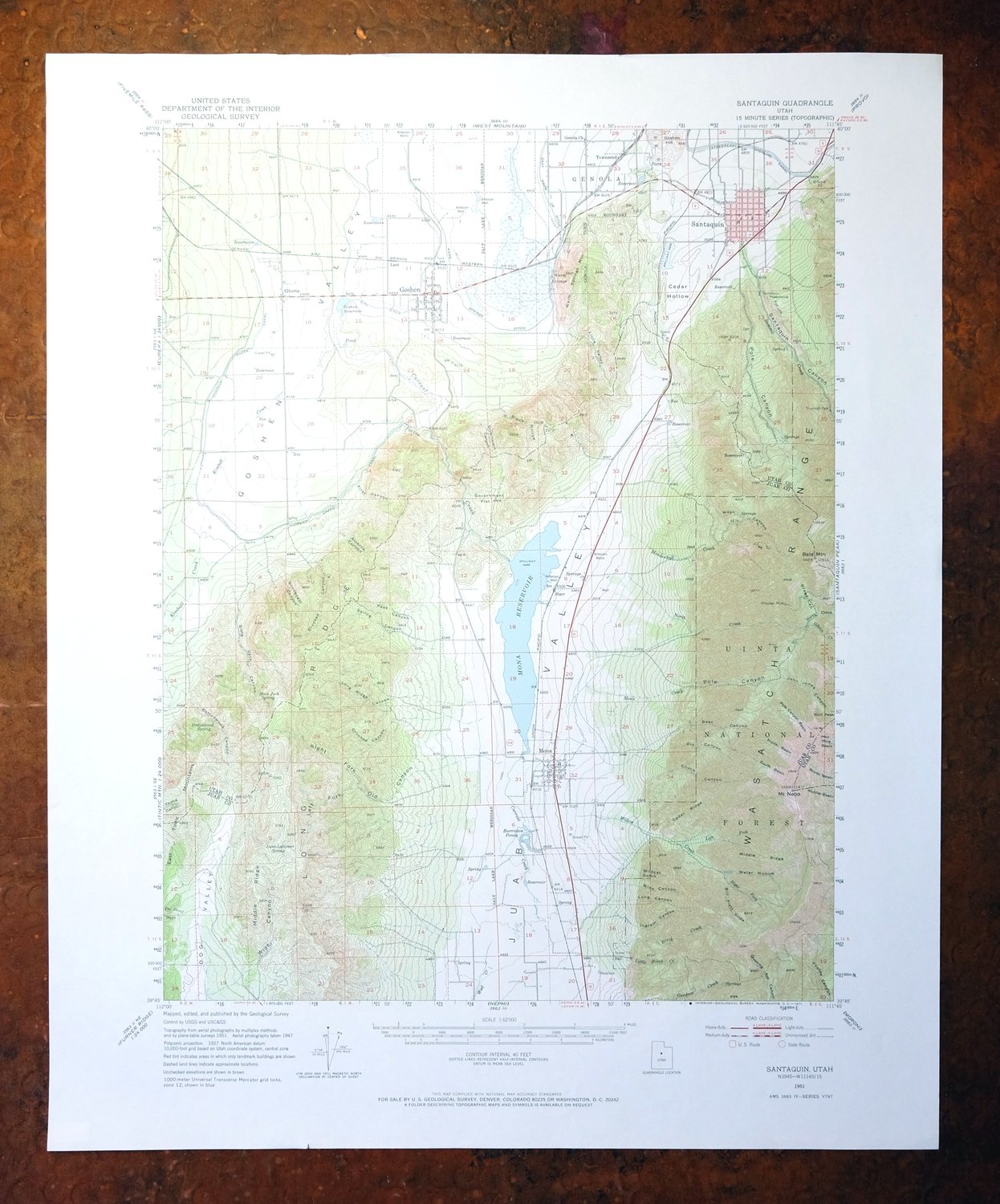
This 15-minute topographic sheet maps the Santaquin quadrangle in north-central Utah, a 1951 edition printed in 1971 at 1:62,500 with woodland areas shown in green. Covering a stretch of Juab and Utah counties southwest of Provo, the quad area takes in Santaquin, Genola, Spring Lake, and Rocky Ridge, along with parts of the Uinta National Forest and the Mount Nebo Wilderness in the Wasatch Range. The sheet has never been folded and lies smooth and flat, with a flawless map area—well suited to framing.
In stock
This vintage sheet is a 1951 edition of the Santaquin Utah USGS topographic map. It is an original 55-year-old 1971 United States Geological Survey print in excellent condition.
HOW THIS MAP CAN BE USED
In addition to making a fascinating conversation piece, this sheet would look great in a frame or on display, make a unique and prized gift for anyone interested in this area, be perfect as a reference for genealogy studies or general historical research, or fill that missing piece in your collection. Maps of this vintage are printed on durable stock and are well-suited for outdoor activities and recreation of all kinds, including hiking, backpacking, hunting, rafting and kayaking, backcountry skiing, geocaching, general exploration, treasure hunting, etc.
FEATURES SHOWN ON THE MAP
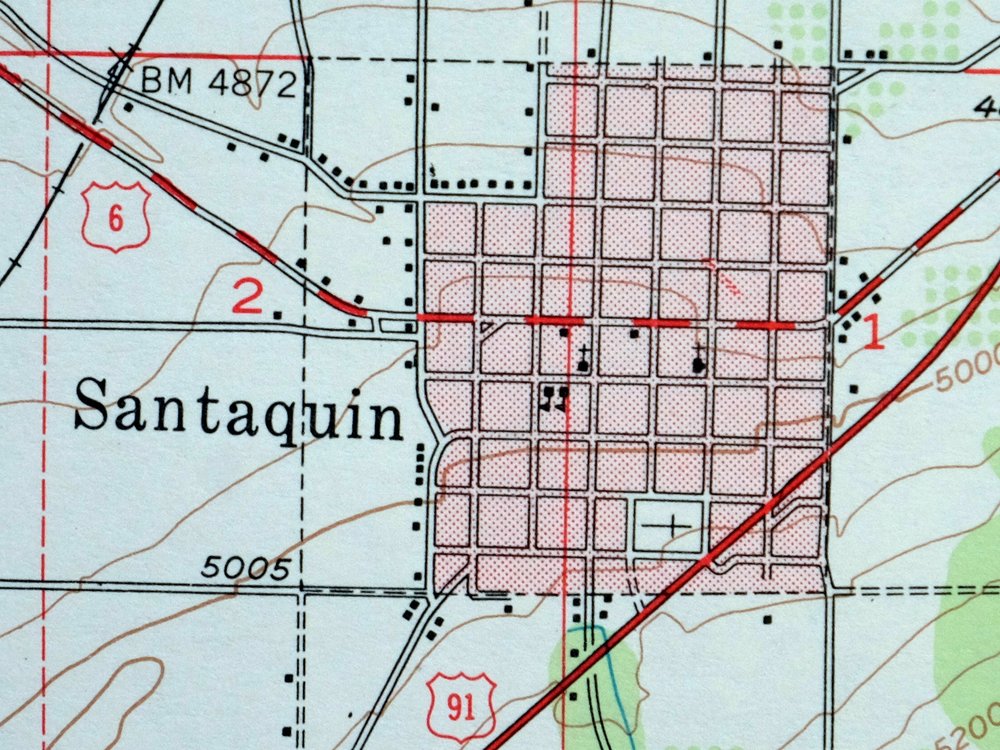
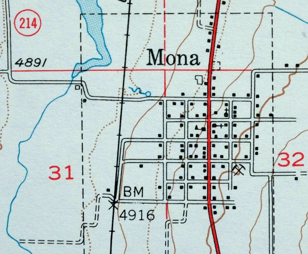
The Santaquin 15-minute map shows cities and towns, roads, railroads, utilities and energy infrastructure, rivers, creeks, elevation contour lines, public land survey lines, county, state, and other administrative boundaries as they existed at the time of the survey in 1947 and 1951. A reddish tint is used on this sheet to indicate urban areas where only landmark buildings are depicted. Outside of those areas, all known structures (houses, businesses, churches, schools, barns, cabins, etc) are shown.
A VALUABLE HISTORICAL RECORD
Maps from the 15-minute series for the continental United States are no longer produced or printed by the USGS and original prints are becoming increasingly difficult to find. They are a valuable historical record for an area, as they contain many placenames and features that have been dropped from more recent maps.
Nearby maps
-
1973 Nephi Utah USGS Topo Map: Levan (San Pitch Mountains)
$42 Add to cart -
Provo Utah Uinta NF Spanish Fork USGS Topo Map 1959 Vintage
$36 Add to cart -

Moroni Utah Fountain Green USGS 15-Min Topo Map 1968 Vintage
$39 Add to cart -
Soldier Summit Utah Gilluly Colton USGS Topographic Map 1942
$49 Add to cart -
1957 USGS Topo Map: Scofield, Clear Creek, Utah (Wattis)
$46 Add to cart -
Stockton Utah Tooele Rush Valley USGS Topo Map 1941 Antique
$32 Add to cart -

Castle Gate Utah Price Helper USGS Topo Map 1968 Vintage
$44 Add to cart -

Castle Dale Utah Ferron Clawson USGS Topographic Map 1925
$47 Add to cart -
1968 USGS Topo Map: Castle Dale, Ferron, Utah (1923 Edition)
$44 Add to cart -
Fillmore Utah Kanosh Meadow USGS 15-Min Topographic Map 1975
$40 Add to cart -
Sunnyside Utah Book Cliffs East Carbon USGS Topo Map 1915
$57 Add to cart -

Hayden Peak Utah Uinta Mountains USGS Topo Map 1946 Vintage
$44 Add to cart -
Woodside Utah Book Cliffs Cedar USGS Topographic Map 1973
$22 Add to cart -
1963 Morgan Utah USGS Topo Map: Devils Slide (Vintage Print)
$45 Add to cart -

Duchesne Utah Roosevelt Neola USGS Topo Map 1939 Antique
$36 Add to cart -
The Wickiup Utah Mexican Mountain WSA USGS Topo Map 1967
$20 Add to cart -
1956 USGS Topo Map: Range Creek, Desolation Canyon, Utah
$42 Add to cart -
Beaver Utah Dixie NF Fishlake NF USGS Topo Map 1921 Antique
$62 Add to cart -
Marysvale Utah Piute Reservoir Junction USGS Topo Map 1947
$44 Add to cart -
1954 USGS Topo Map: Nutters Hole, Desolation Canyon, Utah
$45 Add to cart -
1974 Nutters Hole Utah USGS Topo Map: Desolation Canyon
$38 Add to cart -
1960 Milford Utah USGS Topo Map: Star Range (Vintage Print)
$40 Add to cart -
Notom Capitol Reef NP Utah USGS 15-Min Topo Map 1958 Vintage
$45 Add to cart -
The Spur Utah Canyonlands USGS 15-Min Topo Map 1971 Vintage
$38 Add to cart