MAP DETAILS | |
|---|---|
| TITLE | Uncasville |
| STATE | Connecticut |
| LOCATION | Vicinity of Norwich |
| SERIES | 7.5-minute |
| SURVEYED | 1974 through 1980 Aerial and Field Survey |
| EDITION | 1984 |
| REVISIONS | 1984 |
| PRINTED | 1984 |
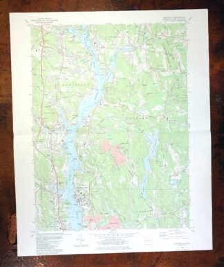
| PRINT NOTES | Includes woodland tint (green to indicate vegetated areas). A reddish tint is used to indicate urban areas where only landmark buildings are shown. |
| SCALE | 1:24000 |
| CONTOUR INTERVAL | 10 feet |
| SHEET DIMENSIONS | 22 x 27 inches |
| MAP DIMENSIONS | 17 1/8 x 22 3/4 inches |
| COVERAGE AREA | 6 x 9 miles |
| SHEET CONDITION For maps of this vintage, effort is made to note all visible flaws, no matter how minor. | |
| OVERALL CONDITION | Very Good |
| SHEET NOTES | lightly handled, midsheet horizontal foldline (in half), title notation pencilled on backside of sheet |
| MAP AREA | no markings, no blemishes |
| COLLARS | no wear or tears, no markings, no blemishes |
| MAP COVERAGE Quadrangle extent overlaid on current basemap. | |
| PLACENAMES Depending on map series and survey date, all of the features listed below may not be shown on this map. This list contains features that currently exist or historically existed within the area covered by the map. The list can be used as a reference to determine if this map covers your area of interest. Placenames are listed alphabetically next to each feature type. | |
| CITIES AND TOWNS (CURRENT) | Conning Towers-Nautilus Park, New London, Norwich, Old Mystic, Oxoboxo River, and Uncasville |
| COUNTIES COVERED | New London |
| FEDERAL LAND UNITS | New London Submarine Base |
| RIVERS AND STREAMS | Falls Brook, Flat Brook, Halsey Brook, Hunts Brook, Lee Brook, Myers Brook, Pine Swamp Brook, Shantok Brook, and Thames River |
| WATER BODIES | Gates Pond, Hallville Pond, Ledyard Reservoir, Morgan Pond Reservoir, Pine Swamp, Rock Pond, Rosemond Lake, and Smith Pond |
| Populated Place: Allyn Point, Bartlett, Center Groton, Fitch Corner, Gales Ferry, Hallville, Happyland, Harrisons, Kitemaug, Ledyard Center, Massapeag, Mohegan, Poquetanuck, Quaker Hill, Quakertown, Thames View, Uncasville, and Nautilus Park. Locations: Bartlett Corners, Best View, Fort Hill, Harvard Boathouse, Montville Station, Old Indian Fort, Quaker Hill, The Ledyard Oak, Yale Boathouse, Crew Rowing Center, Eagle Pier, Grange Hall, Indian Hill Light, Jacobs Rock Sailing and Semanship Center, Ledyard Center Shopping Center, Riverside Village Mall Shopping Center, SCRRRA Industrial Park, Stoddard Landing, and United States Coast Guard Academy Main Gate. Administrative Boundaries: New London County, Town of Ledyard, and Mohegan Reservation. Mountains, Peaks, and Summits: Avery Hill, Bailey Hill, Baldwin Hill, Chapman Hill, Church Hill, Cochegan Rock, Crow Hill, Gungywamp Hill, Haughton Mountain, Long Rock, Mamacoke Hill, Maynard Hill, Mohegan Hill, Red Rock, Rose Hill, Stoddard Hill, Uncas Hill, Vinegar Hill, Allyn Mountain, Bartlett Hill, and Huckleberry Hill. Valleys and Canyons: Sandy Hollow. Parks: Nautilus Park, Stoddard Hill State Park, Cabot Memorial Field, Center Groton Park, Ceravolo Sub Park, Colonel Ledyard Park, Connecticut College Arboretum, Copp Park, Gray Rock Parket, Haley Woods Park, Liberty Square, Meredith Hill Park, Phoenix Drive Park, Robert Crown Park, Romanella Subdivision Park, Trident Park, USS Nautilus Memorial, Waterford Little League Field North, and Watrous Park. Drainages: Beaverdam Brook, Billings Avery Brook, Church Brook, Crowley Brook, Ed Lamb Brook, Falls Brook, Flat Brook, Halsey Brook, Hewitt Brook, Hunts Brook, Joe Clark Brook, Mohegan Brook, Myers Brook, Oxoboxo Brook, Pine Swamp Brook, Poquetanuck Brook, Shantok Brook, Shewville Brook, Stony Brook, Thompson Brook, Tom Allyn Brook, Trading Cove Brook, Indian Creek, and Rose Brook. Islands: Walden Island. Capes: Bailey Point, Bartlett Point, Cow Point, Easter Point, Fort Point, Point Breeze, Brewster Neck, Horton Point, Massapeag Neck, and Poquetanck Point. Churches: Mohegan Church, Coast Guard Memorial Chapel, Ledyard Congregational Church, Monhegan Congregational Church, New Life Church, Our Lady of Perpetual Help Church, Saint Davids Episcopal Church, Saint Johns Church, The Church of Jesus Christ of Latter Day Saints, and Uncasville United Methodist Church. Post Office: Gales Ferry Post Office, Ledyard Post Office, Quaker Hill Post Office, and Uncasville Post Office. Hospitals: Norwich State Hospital. Lakes and Ponds: Gates Pond, Goss Cove, Hallville Pond, Johnson Pond, Long Cove, Rock Pond, Rosemond Lake, Smith Cove, Smith Pond, and Warren Millpond. Buildings: Billard Hall, Gales Ferry and Bill Library, Johnson Hall, Ledyard Library, Lyman Allyn Art Museum Library, Lyman Allyn Museum of Art, McAllister Hall, Michel Hall, Montville Fire Department Company Station 1 / Montville Emergency Medical Services, Nathan Lester House, Naval Undersea Warfare Center-Detachment Technical Library, Officers Row, Pine Hall, Radgowski Annex, Roland Hall, Saint David Episcopal Church Library, Satterlee Hall, Tantaguideon Indian Museum, Thames Science Center, Uncasville Town Hall, United State Naval Submarine Base Library, United States Coast Guard Academy Visitors Center, USS Nautilus Memorial Submarine Force Library and Museum, Yeaton Hall, Center Groton Fire Department Station 7, Connecticut State Police Troop E - Montville, Gales Ferry Volunteer Fire Company, Ledyard Fire Department Company 1, Ledyard Fire Marshal's Office, Ledyard Firefighters Company, Ledyard Volunteer Emergency Services, Mohegan Fire Company Inc., Mohegan Tribal Fire Department, Montville Fire Marshal's Office, Montville Police Department, Poquetanuck Fire Department, Quaker Hill Fire Company 2, Quaker Hill Fire Company 2 Storage, Submarine Base Fire Department Ambulance Station 2, USS Nautilus, and Waterford Ambulance Association. Levees: Long Rock Dike and Trading Cove Dike. Dams: Billings Avery Diversion Pond Dam, Congdon Dam, Gay Cemetery Pond Dam, Hallville Pond Dam, Johnson Pond Dam, Lake Nova Dam, Ledyard Reservoir Dam, Morgan Pond Dam, Trading Cove Pond Dam, and YMCA Pond Dam. Crossings: Stoddard Ferry. Channels: Long Reach Lower and Long Reach Upper. Bays: Bartlett Cove, Clark Cove, Horton Cove, Mamacoke Cove, Mill Cove, Poquetanuck Cove, Trading Cove, and Stoddard Cove. Swamps: Latham Bog and Pine Swamp. Census: Conning Towers Nautilus Park Census Designated Place and Gales Ferry Census Designated Place. Schools: Connecticut College, Poquetanuck Elementary School, Charles Barnum Elementary School, Gales Ferry School, Juliet W Long School, Ledyard Center School, Ledyard Middle School, Mohegan School, Montville Alternate Education Center, Pleasant Valley Elementary School, Quaker Hill Elementary School, and William School. Reservoirs and Tanks: Ledyard Reservoir, Morgan Pond Reservoir, Billings Avery Diversion Pond, Gay Cemetery Pond, Lake Nova, Oxoboro Brook Reservoir, Trading Cove Pond, YMCA Pond, Connecticut College Pond, Latham Reservoir, Pequot Pond, and State Hospital Pond. Military: Naval Submarine Base New London. Flats: The Sandy Desert. Towers: WCNI-FM (New London), WCTY-FM (Norwich), WQGN-FM (Groton), and WSUB-AM (Groton). Bench: Papoose Ledge and Spicer Ledge. Cemetery: Allen Cemetery, Avery Cemetery, Bill Cemetery, Church Hill Cemetery, Gates Cemetery, Gay Cemetery, Lester Cemetery, Morgan Cemetery, Roach Cemetery, Saint Patrick Cemetery, Turner Cemetery, Union Cemetery, Brewster's Neck Cemetery, Comstock Cemetery, Fort Shantok Indian Burying Ground, Gales Ferry Cemetery, Hebrew Cemetery, Lambtown Cemetery, Ledyard Center Cemetery, Levi Chapman Cemetery, Paul Cemetery, Poquetanuck Cemetery, Bolles Cemetery, Newton Cemetery, and Stoddard - Hurlbut Cemetery. | |
| SHIPPING AND RETURNS | |
 This map sheet will be carefully rolled in a sturdy tube and shipped via the US Postal Service. If you find that the sheet you receive is not as described in the listing, you may ship it back to us for a refund of the purchase price. | |


Uncasville Connecticut Ledyard Norwich USGS Topo Map 1984
$34
Printed in its year of first publication, 1984, this USGS 7.5-minute topographic sheet is in very good condition, lightly handled with a single midsheet horizontal foldline. Covering a stretch of New London County in the vicinity of Norwich, the quad area takes in the city of Norwich, the community of Uncasville, and reaches toward New London and Conning Towers-Nautilus Park along the lower Thames River valley. Compiled from aerial and field survey work carried out between 1974 and 1980, it captures the Norwich-to-New London corridor of southeastern Connecticut in fine detail at a 10-foot contour interval. A faint title notation is penciled on the back of the sheet.
In stock
This vintage sheet is a 1984 edition of the Uncasville Connecticut USGS topographic map. It is an original 42-year-old United States Geological Survey print in very good condition.
HOW THIS MAP CAN BE USED
In addition to making a fascinating conversation piece, this sheet would look great in a frame or on display, make a unique and prized gift for anyone interested in this area, be perfect as a reference for genealogy studies or general historical research, or fill that missing piece in your collection. Maps of this vintage are printed on durable stock and are well-suited for outdoor activities and recreation of all kinds, including hiking, backpacking, hunting, rafting and kayaking, backcountry skiing, geocaching, general exploration, treasure hunting, etc.
FEATURES SHOWN ON THE MAP
The Uncasville 7.5-minute map shows cities and towns, roads, paths, railroads, utilities and energy infrastructure, rivers, creeks, elevation contour lines, public land survey lines, county, state, and other administrative boundaries as they existed at the time of the survey in 1974 through 1980. A reddish tint is used on this sheet to indicate urban areas where only landmark buildings are depicted. Outside of those areas, all known structures (houses, businesses, churches, schools, barns, cabins, etc) are shown.
A VALUABLE HISTORICAL RECORD
This map is from the 7.5-minute series, the most detailed series that is widely available from the USGS. The 1984 Uncasville map is a valuable historical record for the area. It contains some placenames and features that have been dropped from more recent maps.
Nearby maps
-

Moodus Connecticut Lake Pocotopaug USGS Topographic Map 1946
$32 Add to cart -
Sag Harbor New York Hampton Bays USGS Topo Map 1913 Antique
$145 Add to cart -

Riverhead New York Manorville Calverton USGS Topo Map 1915
$175 Add to cart -

Blackstone Massachusetts Milford Hopedale USGS Topo Map 1944
$22 Add to cart -

Quinsigamond Massachusetts Milford USGS Topographic Map 1910
$125 Add to cart -
Mansfield Massachusetts Sharon Walpole USGS Topo Map 1961
$18 Add to cart -
Litchfield Connecticut Waterbury Oakville USGS Topo Map 1910
$100 Add to cart -

Holyoke Massachusetts Springfield USGS Topo Map 1897 Antique
$85 Add to cart -
Westport Connecticut Fairfield USGS Topographic Map 1973
$42 Add to cart -
Norwood Massachusetts Boston Dover USGS Topographic Map 1960
$18 Add to cart -

Danbury Connecticut Trumbull Bethel USGS Topo Map 1899
$70 Add to cart -
Norwalk South Connecticut Stamford Darien USGS Topo Map 1963
$40 Add to cart -

West Point New York Newburgh Peekskill USGS Topo Map 1912
$105 Add to cart -

Harlem New York New York Yonkers USGS Topo Map 1913 Antique
$250 Add to cart -
Provincetown Massachusetts USGS Topographic Map 1978 Vintage
$58 Add to cart -

Park Ridge New Jersey New City Ridgewood USGS Topo Map 1963
$45 Add to cart -

Schunemunk New York Newburgh Kiryas Joel USGS Topo Map 1915
$65 Add to cart -

Taconic Vermont Pittsfield Adams USGS Topographic Map 1912
$95 Add to cart -

Troy New York Albany Watervliet USGS Topo Map 1907 Antique
$110 Add to cart -

Goshen New York Middletown Warwick USGS Topographic Map 1913
$55 Add to cart -

Plainfield New Jersey Edison Somerset USGS Topo Map 1965
$42 Add to cart -
Alton New Hampshire Farmington Strafford USGS Topo Map 1977
$12 Add to cart -

New Brunswick New Jersey Spotswood Edison USGS Topo Map 1965
$32 Add to cart -
Amsterdam New York Rotterdam Hagaman USGS Topo Map 1912
$45 Add to cart