MAP DETAILS | |
|---|---|
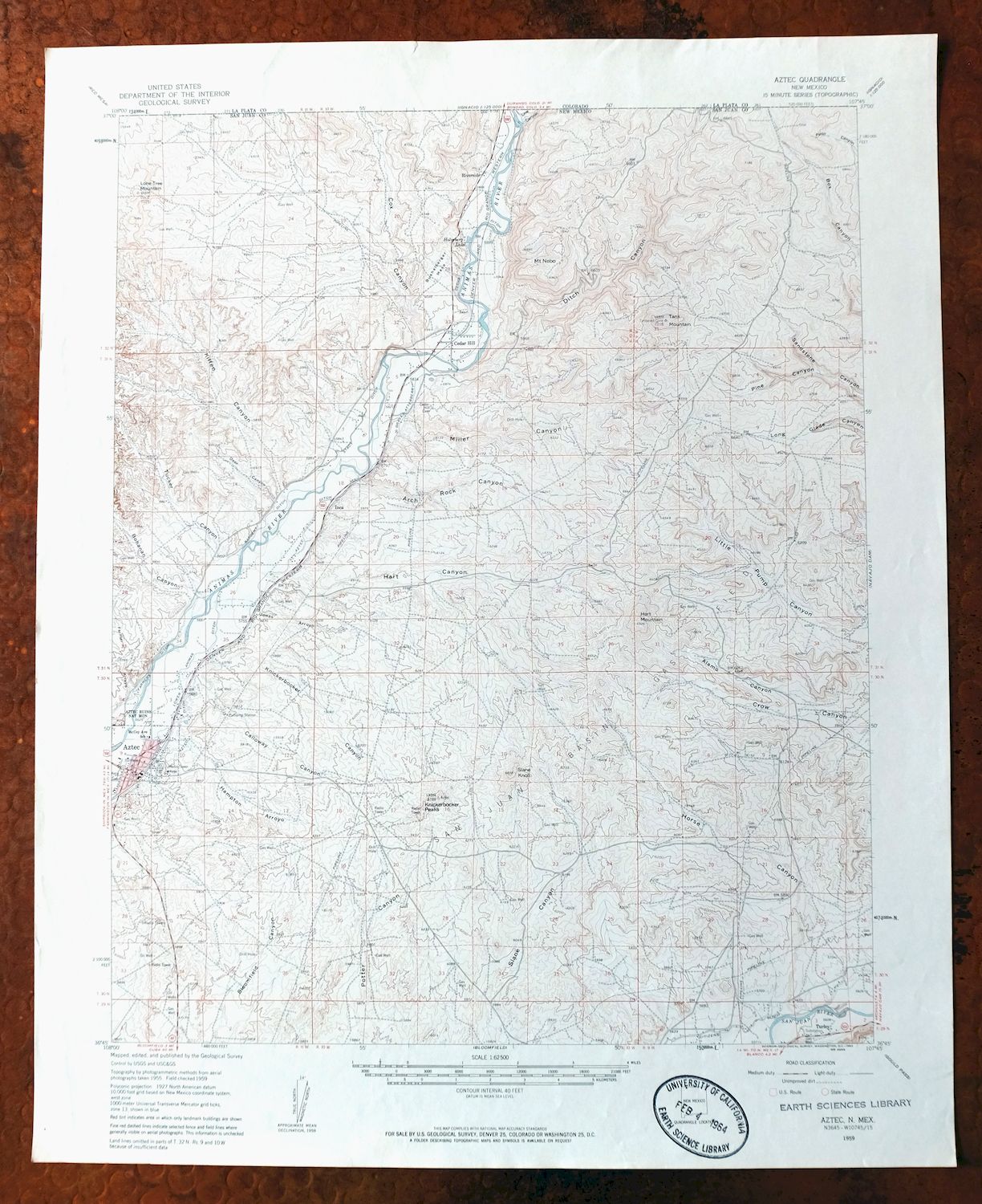
| TITLE | Aztec |
| STATE | New Mexico |
| LOCATION | 20 miles northeast of Farmington |
| SERIES | 15-minute |
| SURVEYED | 1955 and 1959 Aerial and Field Survey |
| EDITION | 1959 |
| PRINTED | 1962 |
| PRINT NOTES | Thick paper stock. A reddish tint is used to indicate urban areas where only landmark buildings are shown. |
| SCALE | 1:62500 |
| CONTOUR INTERVAL | 40 feet |
| SHEET DIMENSIONS | 17 x 21 inches (approximate) |
| MAP DIMENSIONS | 14 x 17 1/2 inches |
| COVERAGE AREA | 14 x 17 miles |
| SHEET CONDITION For maps of this vintage, effort is made to note all visible flaws, no matter how minor. | |
| OVERALL CONDITION | Very Good |
| SHEET NOTES | lightly handled, never folded |
| MAP AREA | flawless map area |
| COLLARS | very minor wear or tears, no markings, no blemishes, slight crease in upper right collar corner, inventory stamp on lower collar |
| MAP COVERAGE Quadrangle extent overlaid on current basemap. | |
| PLACENAMES Depending on map series and survey date, all of the features listed below may not be shown on this map. This list contains features that currently exist or historically existed within the area covered by the map. The list can be used as a reference to determine if this map covers your area of interest. Placenames are listed alphabetically next to each feature type. | |
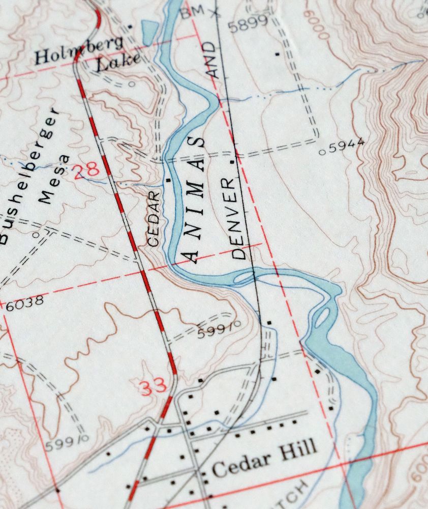
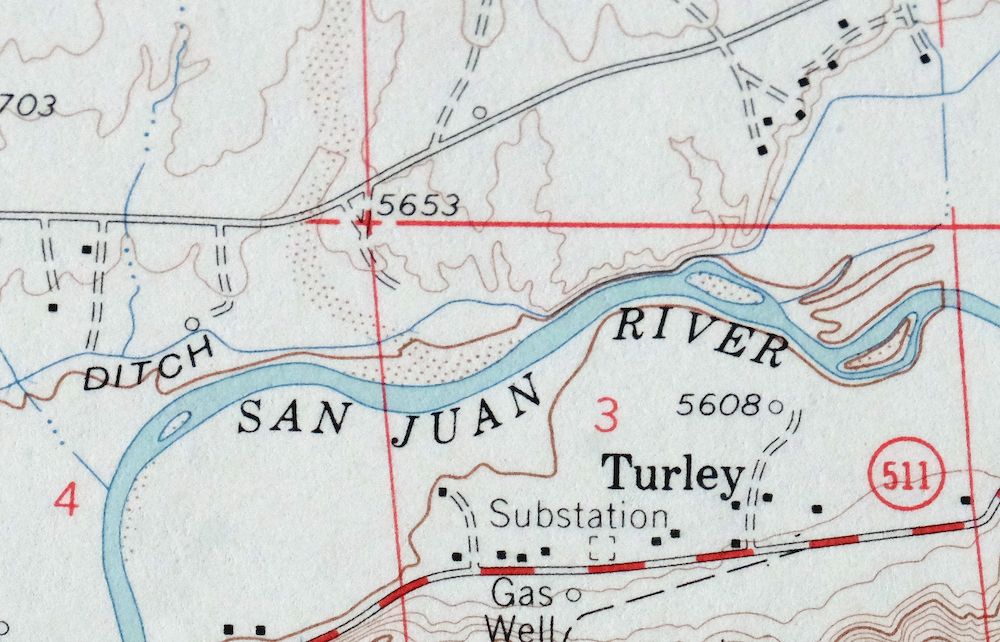
| NOTABLE PLACES | Cedar Hill and Turley |
| CITIES AND TOWNS (CURRENT) | Aztec |
| COUNTIES COVERED | San Juan |
| FEDERAL LAND UNITS | Aztec Ruins National Monument and Southern Ute Indian Reservation |
| RIVERS AND STREAMS | Animas River, Farmer Arroyo, Jones Arroyo, San Juan River, and Williams Arroyo |
| Locations: Aztec Gun Club, Aztec Main Street Historic District, Aztec Weather Station, Church Avenue - Lovers Lane Historic District, and Morris Number 14 Archaeological District. Mountains, Peaks, and Summits: Hart Mountain, Knickerbocker Peaks, Lone Tree Mountain, Mesa Mountains, Mount Nebo, Slane Knob, and Tank Mountain. Valleys and Canyons: Alamo Canyon, Arch Rock Canyon, Bohanan Canyon, Caballo Canyon, Cabin Canyon, Calloway Canyon, Cerritos Canyon, Cox Canyon, Deer Canyon, Ditch Canyon, Flume Canyon, Hampton Arroyo, Hart Canyon, Kitten Canyon, Knowlton Canyon, Line Canyon, Mansfield Canyon, Miller Canyon, Mud Canyon, Pemada Canyon, Pilares Canyon, Pine Canyon, Ruins Canyon, Sidro Canyon, Tucker Canyon, Vaca Canyon, and Vereda Canyon. Parks: Aztec Historical Marker, Aztec Ruins National Monument, and Aztec Ruins National Monument Historical Marker. Drainages: Farmer Arroyo and Jones Arroyo. Churches: Assembly of God Church, Aztec Christian Church, Aztec First Church of the Nazarene, Aztec Presbyterian Church, Bible Baptist Church, Brethel Baptist Church, Church of Christ, Church of God of the Apostolic Faith, First Baptist Church, First United Methodist Church, Jesus Saves Trinity Church, Saint Josephs Catholic Church, Seventh Day Adventist - Aztec Church, Seventh Day Adventist Church, and The Church of Jesus Christ of Latter Day Saints. Lakes and Ponds: Holmberg Lake. Buildings: Alturian Library, Alturian Public Library, American Hotel Historic Site, Austin-McDonald House Historic Site, Aztec Motor Company Building Historic Site, Aztec Museum, D C Ball House Historic Site, Daws-Keys House Historic Site, Denver and Rio Grande Western Railway Depot, Engleman-Thomas Building Historic Site, Fred Bunker House Historic Site, H D Abrams House Historic Site, Harvey McCoy House Historic Site, James McGee House Historic Site, Maurice Case House Historic Site, and McCoy-Maddox House Historic Site. Canals: Aztec Ditch, Cedar Ditch, Graves Atterberry Ditch, Sargent Ditch, and Stacy Ditch. Basins: Beanie Pockets. Natural Arches: Arch Rock and Cox Canyon Arch. Schools: Aztec High School, C V Junior High School, Lydia Rippey Elementary School, McCoy Avenue Elementary School, McCoy Avenue School, and Park Avenue Elementary School. Reservoirs and Tanks: C C Reservoir. Flats: Long Glade. Towers: KCEM-AM (Aztec), KRAZ-FM (Farmington), and KTRA-FM (Farmington). Wells: Hart Canyon Water Well, Knickerbocker Well, Point of Entry Water Well, and SJ-2289 Water Well. Pillars: Bonnie Rock and Lion Rock. Springs: Alamo Spring, Arch Rock, Arch Rock Spring, Banco Spring, Beanie Pockets Spring, Bootlegger Spring, Burro Spring, Caballo Spring, Cash Spring, Cattail Spring, Cave Spring, Crow Spring, Decker Spring, Garrison Spring, Hart Spring, Hart Spring #1, Hart Spring #2, Hart Spring Number 1, Hart Spring Number 2, Headwater Spring, Hidden Springs, High Hopes Spring, Hog Spring, Ice Spring, Indian Spring, Jackson Spring, John Brown Spring, Kirk Spring, Last Chance Spring, Miller Spring, Mud Spring, Pilares Spring, Pipeline Spring, Pueblito Spring, Rawhide Spring, Rincon Spring, Sanchez Spring, Shovel Spring, Stephel Spring, Tank Mountain Spring, Tank Springs, Valencia Spring, and Ventana Spring. | |
| SHIPPING AND RETURNS | |
 This map sheet will be carefully rolled in a sturdy tube and shipped via the US Postal Service. If you find that the sheet you receive is not as described in the listing, you may ship it back to us for a refund of the purchase price. | |
1962 USGS Topo Map: Aztec, Cedar Hill, New Mexico
$40
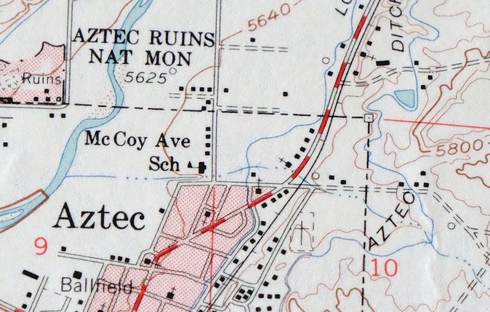
This USGS topographic map covers the Aztec quadrangle in San Juan County, northwestern New Mexico, a 1959 edition printed in 1962 at a scale of 1:62,500. The quad area takes in the town of Aztec about 20 miles northeast of Farmington, along with Cedar Hill and Turley, and includes Aztec Ruins National Monument and the southern edge of the Southern Ute Indian Reservation near the Colorado line. The Monument preserves a large ancestral Puebloan great house along the Animas River. Printed on thick stock, never folded, with a flawless map area.
In stock
This vintage sheet is a 1959 edition of the Aztec New Mexico USGS topographic map. It is an original 64-year-old 1962 United States Geological Survey print in very good condition.
HOW THIS MAP CAN BE USED
In addition to making a fascinating conversation piece, this sheet would look great in a frame or on display, make a unique and prized gift for anyone interested in this area, be perfect as a reference for genealogy studies or general historical research, or fill that missing piece in your collection. Maps of this vintage are printed on durable stock and are well-suited for outdoor activities and recreation of all kinds, including hiking, backpacking, hunting, rafting and kayaking, backcountry skiing, geocaching, general exploration, treasure hunting, etc.
FEATURES SHOWN ON THE MAP
The Aztec 15-minute map shows cities and towns, roads, railroads, utilities and energy infrastructure, rivers, creeks, elevation contour lines, public land survey lines, county, state, and other administrative boundaries as they existed at the time of the survey in 1955 and 1959. A reddish tint is used on this sheet to indicate urban areas where only landmark buildings are depicted. Outside of those areas, all known structures (houses, businesses, churches, schools, barns, cabins, etc) are shown.
A VALUABLE HISTORICAL RECORD
Maps from the 15-minute series for the continental United States are no longer produced or printed by the USGS and original prints are becoming increasingly difficult to find. They are a valuable historical record for an area, as they contain many placenames and features that have been dropped from more recent maps.
Nearby maps
-
1948 Red Mesa Colorado/New Mexico USGS Topo Map
$44 Add to cart -
La Plata Hesperus Colorado USGS 15-Min Topo Map 1956 Vintage
$46 Add to cart -

Ship Rock New Mexico Navajo Mitten Rock USGS Topo Map 1968
$33 Add to cart -
Durango East Colorado USGS 7.5-Min Topo Map 1965 Vintage
$30 Add to cart -
Yellow Jacket Colorado Lewis USGS Topo Map 1968 Vintage
$32 Add to cart -
Chama New Mexico Brazos Tierra Amarilla USGS Topo Map 1973
$39 Add to cart -
1930 San Cristobal Colorado USGS Topo Map: Santa Maria Lake
$33 Add to cart -
Silverton Colorado Camp Bird USGS Topo Map 1962 Vintage
$34 Add to cart -
Cajon Mesa Utah Montezuma Creek USGS Topo Map 1965 Vintage
$34 Add to cart -
Brazos Peak New Mexico USGS 15-Min Topo Map 1971 Vintage
$39 Add to cart -
Toh Atin Mesa Arizona Red Mesa USGS Topo Map 1967 Vintage
$40 Add to cart -
Blanding Utah Montezuma Canyon White Mesa USGS Topo Map 1964
$33 Add to cart -
Buell Park Arizona Fort Defiance Navajo USGS Topo Map 1967
$46 Add to cart -
Iola Colorado USGS 7.5-Min Topographic Map 1963 Vintage
$31 Add to cart -

Hatch Rock La Sal Utah Vintage Original USGS Topo Map 1965
$20 Add to cart -
Bears Ears Utah USGS 15 Minute Topographic Map 1974 Vintage
$46 Add to cart -
Agathla Peak Arizona USGS 15-Min Topo Map 1959 Vintage
$47 Add to cart -
1975 USGS Topo Map: Bernalillo, Cibola NF, New Mexico
$23 Add to cart -
2007 USGS Topo Map: Bernalillo, Cibola NF, New Mexico
$19 Add to cart -
Anthracite Colorado USGS 15-Min Topographic Map 1918 Antique
$38 Add to cart -
Garfield Colorado USGS 15 Minute Topo Map 1945 Vintage
$39 Add to cart -
1974 USGS Topo Map: Garfield, Monarch Pass, Colorado
$45 Add to cart -
Marsh Pass Arizona Kayenta Pinon USGS Topo Map 1922 Antique
$74 Add to cart -
Electric Peak Colorado Sangre de Cristo USGS Topo Map 1974
$33 Add to cart