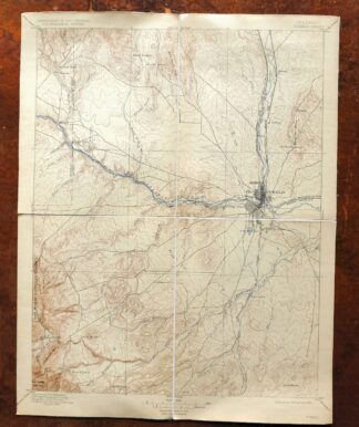
| MAP DETAILS | |
|---|---|
| TITLE | Pueblo |
| STATE | Colorado |
| LOCATION | 40 miles south of Colorado Springs |
| SERIES | 30-minute |
| SURVEYED | 1894 Field Survey |
| GEOGRAPHER | Henry Gannett |
| ENGRAVED | 1896 |
| EDITION | 1897 |
| PRINTED | 1923 |
| SCALE | 1:125000 |
| CONTOUR INTERVAL | 50 feet |
| SHEET DIMENSIONS | 15 1/4 x 19 1/2 inches |
| MAP DIMENSIONS | 13 3/4 x 17 1/2 inches |
| COVERAGE AREA | 27 x 35 miles |
| SHEET CONDITION For maps of this vintage, effort is made to note all visible flaws, no matter how minor. | |
| OVERALL CONDITION | Excellent |
| SHEET NOTES | lightly handled, publisher folds, has original canvas-backing, nicely age-toned sheet |
| MAP AREA | no wear, no markings, no blemishes |
| COLLARS | very minor wear or tears, no markings, no blemishes |
| MAP COVERAGE Quadrangle extent overlaid on current basemap. | |


Pueblo Colorado San Isabel NF Penrose USGS Topo Map 1923
$70
First published in 1897, this canvas-backed sheet was printed in 1923 and survives in excellent condition, lightly handled with publisher folds and a nicely age-toned sheet. Part of the 30-minute series at a scale of 1:125,000, it takes in the Pueblo area of southern Colorado, with the quad boundaries reaching from Pueblo and Pueblo West west toward Penrole and Beulah, and including portions of San Isabel National Forest and the Pueblo Reservoir. The 1894 field survey was carried out under geographer Henry Gannett, and the original canvas backing makes for an unusually durable sheet that folds down to a compact 7 by 10 inches.
In stock
This antique sheet is an 1897 edition of the Pueblo Colorado USGS topographic map. It is an authentic 103-year-old 1923 United States Geological Survey print in excellent condition.
HOW THIS MAP CAN BE USED
In addition to making a fascinating conversation piece, this sheet would look great in a frame or on display, make a unique and prized gift for anyone interested in this area, be perfect as a reference for genealogy studies or general historical research, or fill that missing piece in your collection.
FEATURES SHOWN ON THE MAP
The Pueblo 30-minute map shows cities and towns, roads, railroads, rivers, creeks, elevation contour lines, public land survey lines, county, state, and other administrative boundaries as they existed at the time of the survey in 1894.
A VALUABLE HISTORICAL RECORD
Maps from the USGS 30-minute series have been out of print for many years. They have never been common and original prints are increasingly difficult to find. For areas where the 30-minute map was produced, it is usually the first large-scale survey done by the USGS for that area. These are a valuable historical record, as they contain many placenames and features that have been dropped from more recent series’ and editions.
PLACENAMES
The following places are found within the boundary of this quadrangle. They may or may not be shown or labeled, depending on the map series and vintage.
* Cities and Towns-> Beulah, Beulah Valley, Penrose, Pueblo, Pueblo West, Salt Creek, and Stone City
* Counties Covered-> Fremont and Pueblo
* Federal Land Units-> Fort Carson Military Reservation, Pueblo Reservoir, and San Isabel National Forest
* Rivers and Streams-> Andy Creek, Arkansas River, Beaver Creek, Blue Ribbon Creek, Boggs Creek, Dry Creek, Edson Arroyo, Fountain Creek, Fourmile CreekGalbeth Creek, and others
* Water Bodies-> Comanche Reservoir, North Mills Clarifying Pond, Northside Reservoir, Pueblo Reservoir, Saint Charles Reservoir Number 2, Saint Charles Reservoir Number 3, South Colorado Power Company Reservoir, Southside Reservoirs, and Teller Reservoir
Nearby maps
-

Nepesta Colorado Pueblo Fowler USGS Topo Map 1904 Antique
$45 Add to cart -
Big Springs Colorado Ellicont Rush USGS Topographic Map 1900
$90 Add to cart -
Apishapa Colorado Thatcher Delhi USGS Topo Map 1897 Antique
$74 Add to cart -

Mesa De Maya Colorado Branson Villegreen USGS Topo Map 1901
$67 Add to cart -
Arroyo Colorado Wild Horse Boyero USGS Topo Map 1901 Antique
$90 Add to cart -

Mount Carrizo Colorado Kim Andrix USGS Topographic Map 1901
$68 Add to cart -
Kassler Colorado Roxborough Park Louviers USGS Topo Map 1956
$48 Add to cart -
Highland Ranch Colorado Denver Southglenn USGS Topo Map 1949
$42 Add to cart -
Brilliant New Mexico USGS 15-Min Topo Map 1915 Antique
$70 Add to cart -
Fitzsimons Colorado Denver Aurora USGS Topo Map 1948 Vintage
$42 Add to cart -

Fort Logan Colorado Denver Bow Mar USGS Topographic Map 1941
$38 Add to cart -

Box Elder School Colorado Denver Aurora USGS Topo Map 1942
$56 Add to cart -
Montezuma Colorado Keystone USGS 15-Min Topographic Map 1926
$66 Add to cart -

Eastlake Colorado Westminster Thornton USGS Topo Map 1944
$85 Add to cart -
Aspen Colorado USGS 7.5-Min Topographic Map 1964 Vintage
$58 Add to cart -
Vail West Colorado Avon USGS 7.5-Min Topo Map 1973 Vintage
$38 Add to cart -
Anthracite Colorado USGS 15-Min Topographic Map 1918 Antique
$48 Add to cart -

Cheyenne Wells Colorado Arapahoe USGS Topo Map 1894 Antique
$95 Add to cart -

Mount Powell Colorado Gore Range USGS Topo Map 1940 Antique
$42 Add to cart -
Hot Sulphur Springs Colorado Parshall USGS Topo Map 1963
$40 Add to cart -
Leon White River NF Colorado USGS 7.5-Min Topo Map 1988
$42 Add to cart -

Estes Park Colorado USGS 7.5-Min Topo Map 1961 Vintage
$31 Add to cart -
Silverton Colorado Camp Bird USGS Topo Map 1962 Vintage
$34 Add to cart -

Bonny Reservoir Colorado Hale USGS Topo Map 1969 Vintage
$32 Add to cart