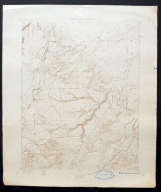
MAP DETAILS | |
|---|---|
| TITLE | Apishapa |
| STATE | Colorado |
| LOCATION | 40 miles southeast of Pueblo |
| SERIES | 30-minute |
| SURVEYED | 1896 Field Survey |
| GEOGRAPHER | E.M. Douglas |
| ENGRAVED | 1897 |
| EDITION | 1897 |
| PRINTED | 1897 |
| PRINT NOTES | Thick paper stock |
| SCALE | 1:125000 |
| CONTOUR INTERVAL | 25 feet |
| SHEET DIMENSIONS | 16 x 20 inches (approximate) |
| MAP DIMENSIONS | 13 7/8 x 17 1/2 inches |
| COVERAGE AREA | 27 x 35 miles |
| SHEET CONDITION For maps of this vintage, effort is made to note all visible flaws, no matter how minor. | |
| OVERALL CONDITION | Very Good |
| SHEET NOTES | lightly handled, never folded, lightly age-toned sheet |
| MAP AREA | flawless map area |
| COLLARS | no markings, minor blemishes, edge wear in upper right collar corner, inventory stamp on right side of bottom collar, repaired edge tears along bottom and left collar |
| MAP COVERAGE Quadrangle extent overlaid on current basemap. | |
| BACKSIDE LEGEND | |
 A map summary is printed on the back side of the Apishapa sheet similar to the one shown in the picture. It outlines the history, purpose, and status of the USGS mapping program at the time of the printing in 1897. It also provides instructions on how to read contour lines and a description of how they are used to depict the terrain. At the bottom of the page is a legend showing all of the symbols used to represent the cultural, relief, and water features found on the map. | |
| PLACENAMES Depending on map series and survey date, all of the features listed below may not be shown on this map. This list contains features that currently exist or historically existed within the area covered by the map. The list can be used as a reference to determine if this map covers your area of interest. Placenames are listed alphabetically next to each feature type. | |
| CITIES AND TOWNS (CURRENT) | Delhi and Thatcher |
| COUNTIES COVERED | Huerfano, Las Animas, Otero, and Pueblo |
| FEDERAL LAND UNITS | Comanche National Grassland and Fort Carson Military Reservation |
| RIVERS AND STREAMS | Apishapa River, Bates Lake Arroyo, Big Arroyo, Buffalo Arroyo, Chicosa Creek, Doyle Arroyo, Elmore Arroyo, Huerfano River, Mustang Creek, Plum Creek, Poitrey Arroyo, Powell Arroyo, Saunders Arroyo, Sorgs Arroyo, South Chicosa Creek, Tejana Arroyo, Timpas Creek, Twomile Arroyo, West Dry Creek, Wild Horse Arroyo, and Yellowbank Creek |
| WATER BODIES | Bates Lake, Cordova Tank, Davis Reservoir, Dry Lake, La Pear Pond, Red Top Reservoir, Schoolhouse Reservoir, Snowden Lake, and South Canyon Lake |
| Locations: A Bar Ranch, Ahern Windmill, Altman Windmill, Black Ranch, Black Windmill, Barbee Windmill, Big Flat Windmill, Big Windmill, Bruenellie Windmill, Bull Pasture Windmill, Fee Windmill, Finn Windmill, Flannery Windmill, Cactus Flat Windmill, Carr Windmill, Chase Ranch, Cordova Windmill, Corner Windmill, Cottonwood Tree Windmill, Deal Windmill, Derringer Windmill, Division Windmill, Double Tank Windmill, East Downer Windmill, English Camp, Eperson Windmill, Fox Windmill, Freds Camp, Gallegos Windmill, Hall Windmill, Harte Ranch, Hidden Valley Ranch, Hixson Windmill, Hog Ranch, Jack Windmill, Jacobs Ranch, Knowlton Ranch, Lou Nelson Ranch, Lower Doyle Windmill, McElhaney Windmill, McGee Windmill, Mustang Ranch, Myers Camp, New Windmill, Newman and Bell Windmill, Patches Windmill, Peterson Windmill, Pool Windmill, Port Arroyo Windmill, Red Top Ranch, Red Windmill, Sanchez Windmill, Sanford Windmill, Smith Ranch Windmill, South Windmill, Spurlock Ranch, Stringer Windmill Number 1, Stringer Windmill Number 2, Sutton Windmill, Thatcher, The Frenchman Windmill, Upper Doyle Windmill, Weinegar Windmill, Wenzel Windmill, West Donner Windmill, West Fork Long Branch, and West Pasture Windmill. Administrative Boundaries: Vigil and Saint Vrain. Mountain Ranges: Big Arroyo Hills, Poitrey Arroyo Hills, Sanford Hills, and Smith Hollow Hills. Mountains, Peaks, and Summits: Blue Hill, Brushy Knob, Flattop Butte, Cone Mountain, Cone Pinnacle, Cordova Mesa, Gobblers Knob, Haystack, Haystack Butte, Little Dome, Mica Butte, North Rattlesnake Butte, Sawtooth Peak, South Rattlesnake Butte, Tater Hill, and Tyler Hill. Valleys and Canyons: Almagre Canyon, Apishapa Canyon, Averson Canyon, Bass Canyon, Berry Canyon, Hudson Canyon, Box Canyon, Bruenellie Canyon, Buck Canyon, Buckletton Canyon, Finch Canyon, Christian Canyon, Cottonwood Canyon, Devils Canyon, Dripping Springs Canyon, East Cross Canyon, East Draw, East Turkey Canyon, Hickok Canyon, Hixson Canyon, Hog Ranch Canyon, Jones Lake Canyon, Juan Baca Canyon, Karrick Canyon, Lambing Canyon, Lone Jack Canyon, Madden Canyon, McElhaney Canyon, Miners Canyon, Myers Canyon, Orr Canyon, Patches Canyon, Peterson Canyon, Plum Canyon, Robins Canyon, Romer Canyon, Smith Hollow, South Canyon, Spring Canyon, Tinaja Canyon, and West Cross Canyon. Parks: Apishapa Game Management Area. Drainages: Bates Lake Arroyo, Big Arroyo, Buffalo Arroyo, Elmore Arroyo, Peterson Creek, Plum Creek, Poitrey Arroyo, Powell Arroyo, Saunders Arroyo, Sorgs Arroyo, Tejana Arroyo, Turkey Creek, Twomile Arroyo, Wild Horse Arroyo, and Yellowbank Creek. Mines: Thatcher Clay Mine and Yellow Banks Dome Pit. Lakes and Ponds: Bates Lake, Church Lakes, Deus Lake, Dry Lake, Karrick Lake, South Canyon Lake, and Twin Lakes. Dams: Brown Dam, Buffalo Arroyo Dam, Jack Williams Dam, and Red Top Dam. Bluffs: Black Bluff, Berry Point, and Yellowbank. Channels: Old Channel Apishapa River. Bridges: Apishapa Bridge. Basins: Karrick Pocket. Schools: South Butte School. Ridges: The Beardsley, Black Ridge, Blue Ridge, Hogback, and Iron Ridge. Reservoirs and Tanks: Altman Reservoir, Baker Reservoir, Bates Reservoir, Baxter Reservoir, Baldwin Reservoir, Berry Reservoir, Big Flannery Reservoir, Big Pit, Bogue Reservoir, Bombing Range Reservoir, Brown Reservoir, Buffalo Arroyo Reservoir, Bull Pasture Reservoir, Federal Reservoir, Butte Reservoir, Cable Reservoir, Canyon Reservoir, Cordova Tank, Davis Reservoir, Doyle Arroyo Reservoir, Doyle Reservoir, East Reservoir, East Tank, Gaalegos Reservoir, Gold Mine Reservoir, Hans Reservoir, Hixon Reservoir, Homestead Reservoir, Iron Ridge Reservoir, Jack Williams Reservoir, Kierce Reservoir, La Pear Pond, Lambert Reservoir, Little Twin Dump Reservoir, Log House Reservoir, Lone Jack Reservoir, Lower Peterson Reservoir, Lyons Reservoir, Machatten Reservoir, Mayer Reservoir, Mobley Reservoir, North Lone Jack Reservoir, Overshaun Reservoir, Overton Reservoir, Peck Reservoir, Peterson Reservoir, Pierce Reservoir, Prairie Dog Reservoir, Price Reservoir, Railroad Fill Reservoir, Red Top Reservoir, Reynolds Reservoir, Rikoff Reservoir, Rock Dam Reservoir, Ronfeldt Reservoir, Rowe Reservoir, School Section Reservoir, Schoolhouse Reservoir, Six Thousand Reservoir, Snowden Lake, South Studebaker Reservoir, Southeast Reservoir, Southwest Reservoir, Stauder Reservoir, Studebaker Reservoir, Tanner Reservoir, Teeple Reservoir, Tickle Tank, Twin Dump Reservoir, United States Government Reservoir, Upper Doyle Reservoir, West Pasture Reservoir Number 1, and West Pasture Reservoir Number 2. Flats: Muddy Flat and Tyrone Flats. Wells: Becker Well, Bull Pasture Well, Bushmire Well, Evans Well, Center Well, Cross Canyon Well, Jolly Well, Linnard Well, Machatten Well, Mare Pasture Well Number 1, Mare Pasture Well Number 2, Monroe Well, North Hixon Well, Oxbow Well, Polder Well Number 1, Polder Well Number 2, Revell Well, School Section Well, Springer Well, Sulfur Well, Teeple Well, and West Well. Springs: Airy Spring, Alum Spring, Averson Spring, Big Dripping Spring, Bobins Pocket Spring, Box Canyon Spring, Box Spring, Cottonwood Spring, Dime Spring, Duran Spring, Harte Spring, Hixon Spring, Hog Springs, El Hondo Spring, Iron Spring, Jones Lake Spring, Karrick Spring, Kitch Spring, Lily Pond Spring, Little Dripping Spring, Merrit Spring, Myers Spring, Nevitt Spring, Oscar Spring, Pacheco Spring, Peck Spring, Ribal Spring, Rowe Spring, Salt Spring, Sanchez Spring, South Peck Spring, Tollers Spring, Upper Woodey Spring, Whiskey Spring, and Woodey Spring. | |
| SHIPPING AND RETURNS | |
 This map sheet will be carefully rolled in a sturdy tube and shipped via the US Postal Service. If you find that the sheet you receive is not as described in the listing, you may ship it back to us for a refund of the purchase price. | |


Apishapa Colorado Thatcher Delhi USGS Topo Map 1897 Antique
$52
Printed in its year of first publication, 1897, this USGS 30-minute topographic sheet is in very good condition, printed on thick stock and never folded, with light age-toning and a flawless map area. Covering country about 40 miles southeast of Pueblo, Colorado, the quad area spans parts of Huerfano, Las Animas, Otero, and Pueblo counties, takes in the communities of Thatcher and Delhi, and includes part of what is now the Comanche National Grassland. Engraved in 1897 under geographer E.M. Douglas and drawn from an 1896 field survey, this antique sheet shows the shortgrass plains of southeastern Colorado as they were surveyed near the close of the nineteenth century, and its reverse carries printed reference material. The sheet has repaired edge tears along the bottom and left collar and an inventory stamp on the bottom collar.
In stock
This antique sheet is an 1897 edition of the Apishapa Colorado USGS topographic map. It is an authentic 129-year-old United States Geological Survey print in very good condition.
HOW THIS MAP CAN BE USED
In addition to making a fascinating conversation piece, this sheet would look great in a frame or on display, make a unique and prized gift for anyone interested in this area, be perfect as a reference for genealogy studies or general historical research, or fill that missing piece in your collection.
FEATURES SHOWN ON THE MAP
The Apishapa 30-minute map shows cities and towns, roads, railroads, rivers, creeks, elevation contour lines, public land survey lines, county, state, and other administrative boundaries as they existed at the time of the survey in 1896.
A VALUABLE HISTORICAL RECORD
Maps from the USGS 30-minute series have been out of print for many years. They have never been common and original prints are increasingly difficult to find. For areas where the 30-minute map was produced, it is usually the first large-scale survey done by the USGS for that area. These are a valuable historical record, as they contain many placenames and features that have been dropped from more recent series’ and editions.
Nearby maps
-

Nepesta Colorado Pueblo Fowler USGS Topo Map 1904 Antique
$45 Add to cart -
Pueblo Colorado San Isabel NF Penrose USGS Topo Map 1923
$52 Add to cart -

Mesa De Maya Colorado Branson Villegreen USGS Topo Map 1901
$44 Add to cart -

Mount Carrizo Colorado Kim Andrix USGS Topographic Map 1901
$40 Add to cart -
Big Springs Colorado Ellicont Rush USGS Topographic Map 1900
$40 Add to cart -
Arroyo Colorado Wild Horse Boyero USGS Topo Map 1901 Antique
$41 Add to cart -

Cheyenne Wells Colorado Arapahoe USGS Topo Map 1894 Antique
$68 Add to cart -
Brilliant New Mexico USGS 15-Min Topo Map 1915 Antique
$47 Add to cart -
Electric Peak Colorado Sangre de Cristo USGS Topo Map 1974
$33 Add to cart -
Koehler New Mexico Maxwell NWR Maxwell USGS Topo Map 1937
$51 Add to cart -
Poncha Springs Colorado Salida Nathrop USGS Topo Map 1970
$41 Add to cart -
Kassler Colorado Roxborough Park Louviers USGS Topo Map 1956
$48 Add to cart -
Platte Canyon Colorado South Platte USGS Topo Map 1955
$44 Add to cart -
Highland Ranch Colorado Denver Southglenn USGS Topo Map 1949
$42 Add to cart -
Brazos Peak New Mexico USGS 15-Min Topo Map 1971 Vintage
$39 Add to cart -
Bailey Colorado Will-O-The-Wisp Wandcrest USGS Topo Map 1973
$40 Add to cart -
Coal Creek Colorado Aurora USGS Topographic Map 1942 Antique
$45 Add to cart -
Shawnee Colorado Singleton USGS Topographic Map 1972 Vintage
$39 Add to cart -
Fitzsimons Colorado Denver Aurora USGS Topo Map 1948 Vintage
$36 Add to cart -

Fort Logan Colorado Denver Bow Mar USGS Topographic Map 1941
$38 Add to cart -
Chama New Mexico Brazos Tierra Amarilla USGS Topo Map 1973
$39 Add to cart -

Box Elder School Colorado Denver Aurora USGS Topo Map 1942
$38 Add to cart -
Georgetown Colorado Idaho Springs USGS Topo Map 1980 Vintage
$42 Add to cart -

Mount Massive Colorado USGS 7.5-Min Topo Map 1975 Vintage
$36 Add to cart