MAP DETAILS | |
|---|---|
| TITLE | Charleston |
| STATE | West Virginia |
| SERIES | 15-minute |
| SURVEYED | 1907 Field Survey |
| GEOGRAPHER | Frank Sutton |
| ENGRAVED | 1909 |
| EDITION | 1909 |
| PRINTED | 1914 |
| PRINT NOTES | Thick paper stock |
| SCALE | 1:62500 |
| CONTOUR INTERVAL | 50 feet |
| SHEET DIMENSIONS | 16 3/8 x 20 inches |
| MAP DIMENSIONS | 13 3/4 x 17 1/2 inches |
| COVERAGE AREA | 14 x 17 miles |
| SOURCE | From an uncommonly well-preserved collection |
| SHEET CONDITION For maps of this vintage, effort is made to note all visible flaws, no matter how minor. | |
| OVERALL CONDITION | Excellent |
| SHEET NOTES | very lightly handled, never folded, smooth and flat |
| MAP AREA | flawless map area |
| COLLARS | no wear or tears, no markings, very minor blemishes, hole punches along left collar |
| MAP COVERAGE Quadrangle extent overlaid on current basemap. | |
| BACKSIDE LEGEND | |
 A map summary is printed on the back side of the Charleston sheet similar to the one shown in the picture. It outlines the history, purpose, and status of the USGS mapping program at the time of the printing in 1914. It also provides instructions on how to read contour lines and a description of how they are used to depict the terrain. At the bottom of the page is a legend showing all of the symbols used to represent the cultural, relief, and water features found on the map. | |
| PLACENAMES Depending on map series and survey date, all of the features listed below may not be shown on this map. This list contains features that currently exist or historically existed within the area covered by the map. The list can be used as a reference to determine if this map covers your area of interest. Placenames are listed alphabetically next to each feature type. | |
| CITIES AND TOWNS (CURRENT) | Big Chimney, Charleston, Coal Fork, Cross Lanes, Dunbar, Malden, Marmet, Pinch, Pocatalico, Rand, Sissonville, and South Charleston |
| COUNTIES COVERED | Kanawha and Putnam |
| RIVERS AND STREAMS | Aarons Creek, Aarons Fork, Alum Creek, Baker Fork, Bat Branch, Bays Fork, Burning Spring Branch, Campbells Creek, Cane Fork, Clay Bank Branch, Coal Fork, Coonskin Branch, Coopers Creek, Davis Creek, Dry Branch, Elk River, Elk Twomile Creek, Falls Branch, Finney Branch, Fisher Branch, Fourmile Fork, Georges Creek, Harmond Creek, Holmes Branch, Huggard Branch, Indian Creek, Joplin Branch, Kanawha Fork, Kanawha River, Lane Branch, Left Fork Brier Creek, Left Fork Spring Fork, Legg Fork Tupper Creek, Lick Branch, Little Brier Creek, Little Coopers Creek, Little Sandy Creek, Little Spring Fork, Long Branch, Lower Donnally Branch, Martin Branch, Meadow Fork Brier Creek, Middle Fork, Middlelick Branch, Mile Fork, Mill Creek, Mink Shoal Run, Mudsuck Branch, Newhouse Branch, Pocatalico River, Pointlick Fork, Rays Branch, Reynolds Branch, Rich Fork, Right Fork Coal Fork, Right Fork Rush Creek, Right Fork Twomile Creek, Rush Creek, Sheldon Rock Branch, Short Branch, Simmons Creek, Spring Fork, Sugar Creek, Threemile Fork, Trace Fork, Tupper Creek, Twomile Creek, Tyler Creek, Union Fork, Wall Fork, Whiteman Fork, Wilkerson Branch, Wolfpen Branch, Woodward Branch, and Younger Branch |
| WATER BODIES | Waste Water Retention Pond |
| Locations: Atkisson Dam Lighthouse, Laidley Court Shopping Center, Camp Virgil Tate, Charleston Town Center Mall Shopping Center, Dunbar Village Shopping Center, Edgewood Country Club, Gateways Shopping Center, Hillcrest Office Park, Kanawha Country Club, Kanawha Mall Shopping Center, Owens Industrial Park, Patrick Street Plaza Shopping Center, Plaza East Shopping Center, Riverwalk Plaza Shopping Center, and Watt Powell Stadium. Administrative Boundaries: District 2 Magisterial District and District 4 Magisterial District. Mountains, Peaks, and Summits: Bald Knob, Holmes Knob, Malden Mountain, and Tyler Mountain. Valleys and Canyons: Kirby Hollow, Blackhawk Hollow, Blacksnake Hollow, Larkin Hollow, Brooks Hollow, Campbells Hollow, Cat Gut Hollow, Chappell Hollow, Clover Hollow, Coal Hollow, Cooks Hollow, Crouch Hollow, Dryden Hollow, Dunlop Hollow, Dutch Hollow, Flood Hollow, Gill Hollow, Green Bottom, Hammack Hollow, Harris Hollow, Hawes Hollow, Hoffman Hollow, Hogpen Hollow, Martin Hollow, Mission Hollow, Number 2 Store Hollow, Nunley Hollow, Payton Hollow, Polly Hollow, Porters Hollow, Ruffner Hollow, Scott Hollow, Shoot Hollow, Shrewsbury Hollow, Surface Hollow, Tarkin Hollow, Ward Hollow, Westfall Hollow, and White Hollow. Parks: Little Creek Park, Blackwell Field, Laidley Field, Booker T Washington State Park, Cato Park, Coonskin Park, Daniel Boone Park, Dunbar Park, East End Historic District, Grasscup Road Historic District, Jefferson Park, Kanawha Riflemens Memorial Park, North Charleston Recreation Center, Ruffner Memorial Park, Spring Hill Cemetery Historic District, Timberland Park, and Walt Powell Park. Drainages: Aarons Creek, Aarons Fork, Little Sandy Creek, Baker Fork, Bat Branch, Bays Fork, Little Spring Fork, Bens Fork, Landers Creek, Lane Branch, Left Fork Spring Fork, Left Fork Twomile Creek, Legg Fork Tupper Creek, Lick Branch, Limestone Branch, Little Coopers Creek, Bonham Branch, Bullskin Branch, Burning Spring Branch, Campbells Branch, Campbells Creek, Cane Fork, Chappel Branch, Chapps Branch, Claylick Branch, Coal Fork, Coolspring Branch, Coonskin Branch, Coopers Creek, Copen Branch, Craig Branch, Davis Creek, Dry Branch, Dutch Fork, Edens Fork, Elk River, Elk Twomile Creek, Falls Branch, Ferry Branch, Fisher Branch, Fivemile Fork, Fourmile Fork, Fudge Branch, Georges Creek, Halls Fork, Hanson Branch, Harmond Creek, Holmes Branch, Huggard Branch, Indian Creek, Joplin Branch, Kanawha Fork, Kaufman Branch, Kelly Branch, Lower Donnally Branch, Long Branch, Magazine Branch, Martin Branch, Middle Fork, Middlelick Branch, Mile Fork, Mill Creek, Mink Shoal Run, Moccasin Branch, Mudsuck Branch, Newhouse Branch, Pfieffer Branch, Pointlick Fork, Portercamp Branch, Pot Branch, Rattlesnake Run, Rays Branch, Rich Fork, Right Fork Coal Fork, Right Fork Rush Creek, Right Fork Twomile Creek, Rock Branch, Rocky Fork, Rush Creek, Schoolhouse Branch, Sheldon Rock Branch, Short Branch, Sigman Fork, Simpson Branch, Spring Branch, Spring Fork, Stitt Branch, Sugar Creek, Sugarcamp Branch, Sugarcamp Creek, Threemile Fork, Trace Fork, Turkeypen Branch, Twomile Creek, Tyler Creek, Union Fork, Upper Donnally Branch, Valley Grove Branch, Venable Branch, Vincent Branch, Wall Fork, Wash Branch, Wolfpen Branch, Wolfpen Run, Woodward Branch, Younger Branch, Whiteman Fork, and Wilkerson Branch. Islands: Blaine Island, Magic Island, Tyler Island, and Wilson Island. Churches: African Zion Baptist Church, Allen Chapel African Methodist Episcopal Church, Asbury United Methodist Church, Baptist Temple, Bethany Baptist Church, Bethel Baptist Church, Beni Kedem Temple, Leggs Memorial Church, Levi Church, Liberty Baptist Church, Liberty Church, Littlepage Church, Bethel Church, Bias Chapel, Bible Center Church, Big Chimney Baptist Church, Blessed Sacrament Roman Catholic Church, Bnai Israel Temple, Bnai Jacob Synagogue, Boulevard Church of Christ, Boyd Memorial Church in Christ, Bream Memorial Presbyterian Church, Brown Church, Calvary Baptist Church, Capital View Church of the Nazarene, Central United Methodist Church, Charleston Seventh Day Adventist Church, Christ United Methodist Church, Church of Christ, Church of God, Church of the Nazarene, Coal Fork United Methodist Church, Community Gospel Church, Community Mission Church, Community Missionary Baptist Church, Coopers Creek Church, Darlington United Methodist Church, Davis Creek Church of God, Dunbar Church of Christ, Dunbar Church of the Nazarene, Dunbar First Church of God, East Point Apostolic Church, Ebenezer Baptist Church, Elizabeth Memorial United Methodist Church, Emmanuel Baptist Church, Fairlawn Baptist Church, Fairview Church, Faith Tabernacle Church, Fifth Avenue Church of God, First Advent Christian Church, First Assembly of God Church, First Baptist Church, First Baptist Church of Dunbar, First Baptist Church of South Charleston, First Christian Church, First Church of Christ Scientist, First Church of God, First Church of the Nazarene, First Church of the Nazarene of South Charleston, First Pentecostal Church, First Presbyterian Church, First United Methodist Church of South Charleston, Good Shepherd Church of God in Christ, Grace Church of the Nazarene, Grace Methodist Church, Greenlee Chapel, Griffith Chapel, Hannah Drive Church, Hanson Chapel, Harper Memorial Church, Highland Avenue Baptist Church, Hobbs Memorial Presbyterian Church, Holiness Church of Christ, Holy Spiritual Church of God, Humphreys Memorial United Methodist Church, Kanawha City Baptist Church, Kanawha Fork Church, Kanawha Salines Presbyterian Church, Kanawha United Presbyterian Church, Loudendale Freewill Baptist Church, Malden Baptist Church, Malden Methodist Episcopal Church, Maple Hill Church, McKinnon Church, Metropolitan Baptist Church, Morris Memorial United Methodist Church, Mount Calvary Baptist Church, Mount Olive Church, Mount Pisgah Church, Mount Zion Baptist Church, Mountain Mission Church, North Side Church of the Nazarene, Oakridge Bible Church, Ohio Street Church of God, Open Door Apostolic Church, Parsons Chapel Adventist Church, Pentecostal Holiness Church, Pilgrim Holiness Church, Pleasant Valley Church, Pointlick Church, Randolph Street Baptist Church, Riverview Baptist Church, Robson Presbyterian Church, Rock Lake Presbyterian Church, Rose of Sharon Christian Fellowship Church, Ruffner Memorial Presbyterian Church, Sacred Heart Convent, Sacred Heart Roman Catholic Church, Saint Agnes Roman Catholic Church, Saint Anthony Roman Catholic Church, Saint George Orthodox Church, Saint James Episcopal Church, Saint John Greek Orthodox Church, Saint Johns Episcopal Church, Saint Lukes Episcopal Church, Saint Lukes Methodist Church, Saint Marks United Methodist Church, Saint Matthews Episcopal Church, Saint Paul African Methodist Episcopal Church, Saint Paul United Methodist Church, Saint Pauls Lutheran Church, Saint Timothy Lutheran Church, Seventh Avenue Church of God, Shepherd United Methodist Church, Shiloh Baptist Church, Silas Church, Simpson Memorial United Methodist Church, Sixth Street Methodist Episcopal Church, South Charleston Christian Church, South Ruffner Presbyterian Church, Southeast Church of the Nazarene, Southwest Church of God, Spring Hill Baptist Church, Spring Hill Church of Christ, Starcher Baptist Church, Sugar Creek Missionary Baptist Church, Temple Baptist Church, Thompson Chapel, Trinity Church, Trinity Evangelical Lutheran Church, Tupper Valley Church, Tupper Valley Gospel Tabernacle, Union Mission, Universalist Fellowship of Kanawha Valley, Utah Church, Vandalia Baptist Church, Village Chapel Presbyterian Church, Walker Church, Walls African Methodist Episcopal Church, Weekley United Methodist Church, Wesley United Methodist Church, Woodward Woods Church, and Westminster Presbyterian Church. Forests: Kanawha State Forest. Hospitals: Charleston Area Medical Center, Charleston Area Medical Center-General Division, Eye and Ear Clinic of Charleston, Herbert J Thomas Memorial Hospital, Highland Hospital, Hillcrest Sanitarium, Memorial Hospital, Saint Francis Hospital, Southern Hills Hospital, Staats Hospital, and Women and Childrens Hospital. Buildings: Andrew S Thomas Memorial Library, Benedum Hall, Charleston Art Gallery, Charleston City Hall, Cox Hall, Dickinson Hall, Dunbar City Hall, Elm Grove, Fire Station Number 1, Fire Station Number 2, Holly Grove, John F Kennedy Center, Kanawha County Courthouse, Kanawha County Jail, Kanawha County Public Library, North Charleston Fire Station, Second Avenue Community Center, South Charleston Branch Kanawha County Public Library, Sunrise Bird Sanctuary Museum, Vernon Cobb Hall, West Virginia Archives and History Division Library, West Virginia Legislative Reference Library, and West Virginia State Capitol. Dams: Cunningham Flyash Disposal Pond Number Four Dam, Elk Twomile Creek Structure Number 13 Dam, Elk Twomile Structure Number 12 Dam, Fmc Waste Retention Basin Dam, Marmet Locks, Marmet Locks and Dam, Scotts Run Cinder Barrier Dam, and Shoal Dam. Crossings: Interchange 100, Interchange 101, Interchange 102, Interchange 104, Interchange 106, Interchange 111, Interchange 53, Interchange 54, Interchange 56, Interchange 58A, Interchange 58B, Interchange 58C, Interchange 95, Interchange 96, Interchange 97, Interchange 98, and Interchange 99. Bridges: Kanawha City Bridge, Patrick Street Bridge, South Side Bridge, and Yeager Bridge. Bars: Mink Shoals. Airports: CAMC - General Rooftop Heliport, CAMC Memorial Helistop - ground level, Mallory Airport, and Yeager Airport. Schools: Aarons Fork School, Aetna-Dell School, Airport School, Alpha School, Barbe School, Baxter School, Kyle Elementary School, Lincoln School, Littlepage School, Bonham School, Buena Vista School, Cabell Alternative High School, Cane Fork School, Capitol School, Carver Career and Technical Center, Chamberlin School, Chandler School, Charleston Catholic High School, Charleston High School, Dupont Junior High School, Dupont Senior High School, Edison Elementary School, Fernbank Public School, Ford School, Fort Hill Elementary School, Fruth School, George Washington High School, Glenwood School, Grandview School, Holtz Elementary School, Horace Mann School, Hubbard School, Jackson High School, Jefferson Junior High School, John Adams Junior High School, Kanawha City School, Kanawha School, Kenna Elementary School, Lower Mill Creek School, Loudon High School, Lowland School, Malden Elementary School, Martin Branch School, Martin School, McGwiggan Public School, McKinley School, Mercer School, Middle Ridge School, Midkiff School, Midway School, Miller School, Montrose School, Morning Star School, Morris Harvey College, Mound School, Oak Ridge School, Oakwood Elementary School, Overbrook Elementary School, Owens School, Parsons School, Piedmont Elementary School, Piney Point School, Rand Elementary School, Richmond Elementary School, Riverview School, Robins School, Roosevelt School, Roxalana School, Ruffner Elementary School, Sacred Heart School, Saint Agnes School, Saint Anthonys School, Shoals Elementary School, Simmons Creek School, Sliphill School, South Charleston Junior High School, South Charleston Senior High School, South Park School, Spring Hill Elementary School, Spring Hill Junior High School, Staunton School, Sugar Creek School, Sunset School, Taft School, Technical High School, Tiskelwah Elementary School, Tyler Elementary School, Union School, Valley Grove School, Vandalia School, Village School, Wallace Heights School, Walnut Gap School, Watts School, Weberwood Elementary School, and Wilson High School. Ridges: Means Ridge and Middle Ridge. Reservoirs and Tanks: Cool Lake, Cunningham Fly Ash Pond, Dupont Waste Lake, and Waste Water Retention Pond. Towers: WBES-FM (Dunbar), WCAW-AM (Charleston), WCZR-AM (Charleston), WJYP-FM (South Charleston), WLZT-FM (Miami), WMSP-AM (Elk Hills), WQBE-AM (Charleston), WQBE-FM (Charleston), WSCW-AM (South Charleston), WTUN-FM (Pocatalico), WVAF-FM (Charleston), WVNS-FM (Charleston), WVPN-FM (Charleston), WVSR-AM (Charleston), WVSR-FM (Charleston), and WYQC-FM (Charleston). Springs: Carl Woods Spring, Columbia Carbon Company Spring, and Thayer Spring. | |
| SHIPPING AND RETURNS | |
 This map sheet will be carefully rolled in a sturdy tube and shipped via the US Postal Service. If you find that the sheet you receive is not as described in the listing, you may ship it back to us for a refund of the purchase price. | |
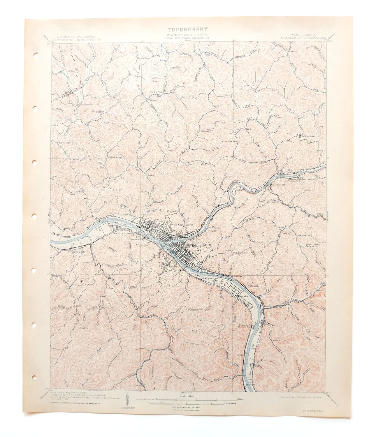

Charleston West Virginia Cross Lanes Rand USGS Topo Map 1914
$75
This 1909 edition of the Charleston, West Virginia quad was printed in 1914, an antique sheet in excellent condition: very lightly handled, never folded, smooth and flat, on thick stock, with only hole punches along the left collar. Covering parts of Kanawha and Putnam counties, the quad area takes in Charleston, South Charleston, and Dunbar along the Kanawha River, with Cross Lanes, Sissonville, Malden, and Big Chimney also within its boundaries. Engraved in 1909 under geographer Frank Sutton from a 1907 field survey, the map records the state capital and its surrounding river valley as they stood a century ago, and it comes from an uncommonly well-preserved collection. The reverse carries printed USGS reference material.
In stock
This antique sheet is a 1909 edition of the Charleston West Virginia USGS topographic map. It is an authentic 112-year-old 1914 United States Geological Survey print in excellent condition.
HOW THIS MAP CAN BE USED
In addition to making a fascinating conversation piece, this sheet would look great in a frame or on display, make a unique and prized gift for anyone interested in this area, be perfect as a reference for genealogy studies or general historical research, or fill that missing piece in your collection.
FEATURES SHOWN ON THE MAP
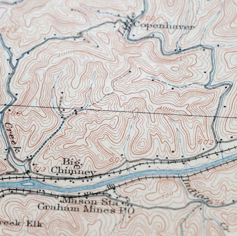
The Charleston 15-minute map shows cities and towns, roads, railroads, rivers, creeks, elevation contour lines, public land survey lines, county, state, and other administrative boundaries as they existed at the time of the survey in 1907. All known structures (houses, businesses, churches, schools, barns, cabins, etc) are also shown, with exceptions in some urban areas, where only landmark buildings may be shown.
A VALUABLE HISTORICAL RECORD
Maps from the 15-minute series for the continental United States are no longer produced or printed by the USGS and original prints are becoming increasingly difficult to find. They are a valuable historical record for an area, as they contain many placenames and features that have been dropped from more recent maps.
Nearby maps
-

Saint Albans West Virginia Dunbar USGS Topographic Map 1909
$37 Add to cart -

Peytona West Virginia Marmet Belle USGS Topographic Map 1911
$42 Add to cart -

Winfield West Virginia Bancroft Southside USGS Topo Map 1908
$37 Add to cart -

Bald Knob West Virginia Mallory USGS Topo Map 1923 Antique
$50 Add to cart -

Ravenswood West Virginia New Haven Evans USGS Topo Map 1908
$40 Add to cart -

Point Pleasant West Virginia Middleport USGS Topo Map 1908
$25 Add to cart -

Wayne West Virginia Dunlow Cove Gap USGS Topo Map 1909
$42 Add to cart -

Pomeroy Ohio Middleport Mason USGS Topo Map 1907 Antique
$37 Add to cart -

Charleston West West Virginia Dunbar USGS Topo Map 1978
$22 Add to cart -

Pocatalico West Virginia Dunbar USGS Topographic Map 1977
$30 Add to cart -

Oceana West Virginia Logan Gilbert USGS Topographic Map 1912
$58 Add to cart -

Raleigh West Virginia Beckley Oak Hill USGS Topo Map 1901
$95 Add to cart -

Nicholas West Virginia Summersville Cowen USGS Topo Map 1912
$54 Add to cart -

Sutton West Virginia Glenville Elk River USGS Topo Map 1907
$110 Add to cart -

Warfield West Virginia Pikeville Harts USGS Topo Map 1911
$105 Add to cart -

Kenova Kentucky Louisa Grayson USGS Topo Map 1912 Antique
$54 Add to cart -

Parkersburg Ohio Marietta Vienna USGS Topo Map 1912 Antique
$63 Add to cart -

Marietta Ohio Wayne NF Devola USGS Topo Map 1912 Antique
$62 Add to cart -

Saint Marys West Virginia Ellenboro Pike USGS Topo Map 1916
$47 Add to cart -

Garrison Kentucky Portsmouth York USGS Topo Map 1918 Antique
$32 Add to cart -

Salyersville Kentucky West Liberty Zag USGS Topo Map 1918
$47 Add to cart -

Whitesburg Kentucky Pikeville Cumberland USGS Topo Map 1910
$115 Add to cart -

Natural Bridge Virginia Covington Selma USGS Topo Map 1911
$62 Add to cart -
Seaman Ohio West Union West Union USGS Topo Map 1918 Antique
$62 Add to cart
