MAP DETAILS | |
|---|---|
| TITLE | Winfield |
| STATE | West Virginia |
| LOCATION | 25 miles northwest of Charleston |
| SERIES | 15-minute |
| SURVEYED | 1906 Field Survey |
| GEOGRAPHER | H.M. Wilson |
| ENGRAVED | 1908 |
| EDITION | 1908 |
| PRINTED | 1908 |
| PRINT NOTES | Thick paper stock |
| SCALE | 1:62500 |
| CONTOUR INTERVAL | 50 feet |
| SHEET DIMENSIONS | 16 1/2 x 20 inches |
| MAP DIMENSIONS | 13 5/8 x 17 1/2 inches |
| COVERAGE AREA | 13 x 17 miles |
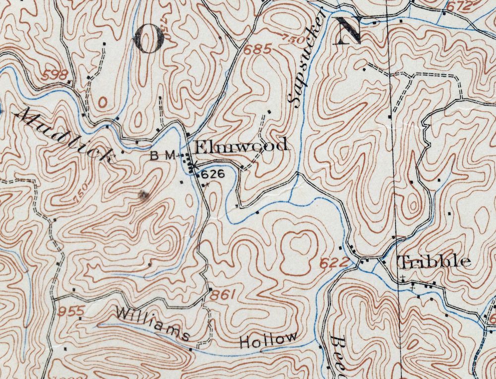
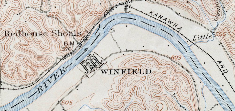
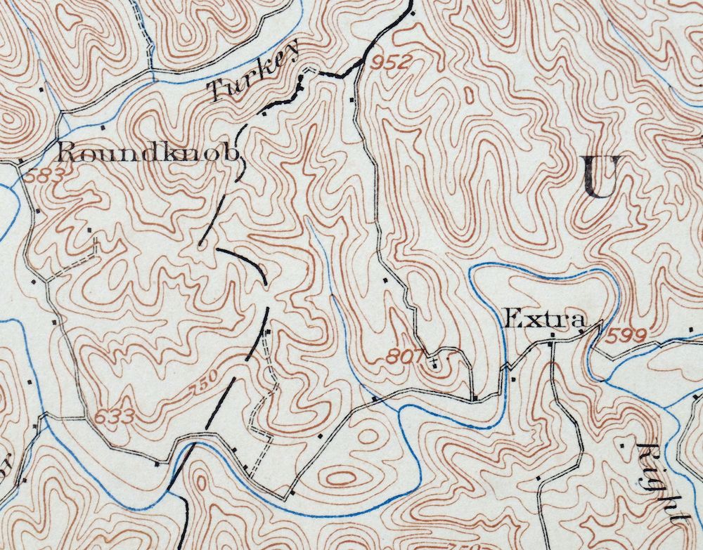
| MAP NOTES | Surveyed before the modern highway system, showing historic travel routes, rail lines, and placenames. |
| SHEET CONDITION For maps of this vintage, effort is made to note all visible flaws, no matter how minor. | |
| OVERALL CONDITION | Good |
| SHEET NOTES | moderately handled, never folded, attractively age-toned paper |
| MAP AREA | minor wear, no markings, very minor blemishes |
| COLLARS | minor blemishes, a few tears have been carefully repaired on backside of sheet using archival tape, pencilled notation in upper right collar corner, small inventory stamp in bottom right collar |
 | |
| MAP COVERAGE Quadrangle extent overlaid on current basemap. | |
| BACKSIDE LEGEND | |
 A map summary is printed on the back side of the Winfield sheet similar to the one shown in the picture. It outlines the history, purpose, and status of the USGS mapping program at the time of the printing in 1908. It also provides instructions on how to read contour lines and a description of how they are used to depict the terrain. At the bottom of the page is a legend showing all of the symbols used to represent the cultural, relief, and water features found on the map. | |
| PLACENAMES Depending on map series and survey date, all of the features listed below may not be shown on this map. This list contains features that currently exist or historically existed within the area covered by the map. The list can be used as a reference to determine if this map covers your area of interest. Placenames are listed alphabetically next to each feature type. | |
| CITIES AND TOWNS (CURRENT) | Bancroft, Buffalo, Eleanor, Leon, Plymouth, Robertsburg, and Winfield |
| COUNTIES COVERED | Jackson, Kanawha, Mason, and Putnam |
| RIVERS AND STREAMS | Arbuckle Creek, Bailey Branch, Baker Branch, Bee Run, Beech Fork, Beechlick Run, Bigger Branch, Bill King Branch, Buffalo Branch, Buffalo Creek, Buzzard Creek, Cabin Creek, Cherry Fork, Clear Fork, Clendenin Creek, Courtney Branch, Cross Creek, Dales Branch, Daves Branch, Dry Branch, Dunlap Branch, Eightmile Creek, Flat Branch, Grasslick Run, Guano Creek, Harmon Branch, Harris Branch, Heizer Creek, Hill Branch, Horse Creek, Hurricane Creek, Isaacs Branch, Kanawha River, Kessel Run, Left Fork Clendenin Creek, Left Fork Turkey Branch, Limekiln Branch, Little Buffalo Creek, Little Hurricane Creek, Little Sixteenmile Creek, Little Spruce Run, Long Branch, Lowgap Fork, Lukes Branch, Manila Creek, Martins Branch, McCausland Run, Mudlick Fork, Otter Branch, Painters Branch, Peppermint Creek, Plantation Creek, Pond Branch, Poplar Fork, Right Fork Eighteenmile Creek, Rocky Fork, Saltlick Creek, Sapsucker Run, Shady Fork, Sigman Fork, Sixteenmile Creek, Spanish Oak Branch, Spring Valley Branch, Spruce Run, Stave Branch, Stumpy Run, Sugar Branch, Sulug Branch, Sycamore Branch, Thirteenmile Creek, Tucker Branch, Turkey Branch, Wolf Creek, and Yeager Fork |
| Locations: Bronco Junction Asthmatic Camp, Deerlick, Eleanor Industrial Park, Eleanor Plaza Shopping Center, Johnson Shoal Light, Nat, Rock Castle, and Webb Landing. Administrative Boundaries: Buffalo-Union Magisterial District, Pocatalico Magisterial District, Scott Magisterial District, and Union Magisterial District. Mountains, Peaks, and Summits: Parker Hill. Valleys and Canyons: Alcocks Hollow, Boardman Hollow, Buckelew Hollow, Coal Hollow, Long Hollow, Slab Hollow, Slaty Hollow, Sulphur Hollow, Tacoma Hollow, Tightsqueeze Hollow, Washington Hollow, and Williams Hollow. Parks: Holiday Park. Drainages: Little Sixteenmile Creek, Arbuckle Creek, Bailey Branch, Baker Branch, Bear Branch, Bee Run, Beech Fork, Beechlick Run, Lindsey Branch, Left Fork Clendenin Creek, Left Fork Turkey Branch, Limekiln Branch, Little Buffalo Creek, Little Buzzard Creek, Little Guano Creek, Little Hurricane Creek, Little Spruce Run, Bigger Branch, Bill King Branch, Bucklick Creek, Buffalo Branch, Buffalo Creek, Buzzard Creek, Cabin Creek, Cherry Fork, Clear Fork, Clendenin Creek, Courtney Branch, Cross Creek, Dales Branch, Daves Branch, Dunlap Branch, Eighteenmile Creek, Flat Branch, Guano Creek, Gumlick Run, Harmon Branch, Harris Branch, Hedrick Branch, Hill Branch, Horse Creek, Hurricane Creek, Isaacs Branch, Jakes Run, Long Branch, Lowgap Fork, Lukes Branch, Martins Branch, McCausland Run, Mudlick Fork, Otter Branch, Painters Branch, Peppermint Creek, Plantation Creek, Poplar Fork, Right Fork Clendenin Creek, Right Fork Eighteenmile Creek, Rocky Fork, Saltlick Creek, Sapsucker Run, Second Branch, Shady Fork, Sigman Fork, Sixteenmile Creek, Spanish Oak Branch, Spring Valley Branch, Spruce Run, Stumpy Run, Sulug Branch, Sycamore Branch, Tom Allen Creek, Tom Lick Run, Tucker Branch, Turkey Branch, Warner Branch, Wolf Creek, and Yeager Fork. Churches: Adda Church, Arbuckle Church, Barnett Community Chapel, Bowles Ridge Church, Buffalo Presbyterian Church, Center Point Church, Cross Creek Church, Dunlap Chapel, First Baptist Church of Eleanor, Grandview Church, Harmony Church, Lone Oak Church, Long Hollow Church, Mahila Chapel, Mount Prospect Church, Mount Zion Church, New Antioch Church, New Hope Church, New Moss Chapel, New Mount Olive Church, Oak Ridge Church, Oma Church, Otter Branch Church, Pleasant Grove Church, Pliny Church, Promise Land Church, Riffle Chapel, Riverside Church, Rock Castle Church, Shiloh Church, Smith Church, Turkey Branch Church, Wade Chapel, Walker Chapel, Winfield Church of Christ, and Wolf Valley Church. Buildings: Bancroft Town Hall, Buffalo Branch Putnam County Library, Buffalo Town Hall, Eleanor Branch Putnam County Library, Eleanor Town Hall, and Putnam County Courthouse. Dams: Winfield Lock Dam Number 1, Winfield Locks and Dam, and Winfield Public Water Supply Dam. Airports: Leon Airport. Schools: Arbuckle School, Lincoln School, Leon School, Buffalo Academy, Buffalo Elementary School, Buffalo High School, Cloverdale School, Confidence Elementary School, Cross Creek School, Crown Hill School, George Washington Elementary School, George Washington Middle School, Hodges School, Hometown Elementary School, Lone Grove School, New Home School, New Jersey School, Oklahoma School, Putnam Vocational-Technical Center, Robinson School, Sandhill School, White Star School, Winfield Elementary School, Winfield High School, and Winfield Middle School. Ridges: Bee Ridge, Buffalo Ridge, Cain Ridge, Calispell Ridge, Cross Creek Ridge, Fisher Ridge, Grandview Ridge, Hudson Ridge, Jim Ridge, Manila Ridge, Morrison Ridge, Pleasant Ridge, Riffee Ridge, Sandhill Ridge, and Wildcat Ridge. Reservoirs and Tanks: Winfield Locks and Dam. Springs: Arnie Craigo Spring, Arnold Hoffman Spring, Arthur Barnett Spring, Bennett Spring, Bowles Spring, Casto Spring, Charles Castro Spring, Charles Hoffman Spring, Cobb Spring, Densil Jividen Spring, Early Castro Spring, Ernest Tucker Spring, Haynes Spring, Henson Spring, Hoffman Spring, Homer Bateman Spring, Hooten Spring, Hulbert Spring, Hull Spring, John Capito Spring, John Henson Spring, John Lloyd Spring, Kenneth Asbury Spring, Maxil Fisher Spring, Paul Crago Spring, Pennington Spring, Ray Woodall Spring, Robert Parkins Spring, Roush Spring, Shank Spring, Stowers Spring, Walter Hoffman Spring, and Witt Spring. | |
| SHIPPING AND RETURNS | |
 This map sheet will be carefully rolled in a sturdy tube and shipped via the US Postal Service. If you find that the sheet you receive is not as described in the listing, you may ship it back to us for a refund of the purchase price. | |





Winfield West Virginia Bancroft Southside USGS Topo Map 1908
$37
Printed in its year of first publication, 1908, this antique USGS 15-minute topographic sheet is in good condition, never folded and printed on thick stock with attractively age-toned paper. The quad sits about 25 miles northwest of Charleston along the Kanawha River, taking in Winfield, Eleanor, and Buffalo and spilling across Putnam, Kanawha, Mason, and Jackson counties. Surveyed in 1906 by H.M. Wilson and engraved in 1908, it predates the modern highway system and records the wagon roads, rail lines, and placenames of the era, and the reverse carries printed reference material on reading the map. A few tears have been carefully repaired on the back with archival tape, and there is a pencilled notation and small inventory stamp in the collar.
In stock
This antique sheet is a 1908 edition of the Winfield West Virginia USGS topographic map. It is an authentic 118-year-old United States Geological Survey print in good condition.
HOW THIS MAP CAN BE USED
In addition to making a fascinating conversation piece, this sheet would look great in a frame or on display, make a unique and prized gift for anyone interested in this area, be perfect as a reference for genealogy studies or general historical research, or fill that missing piece in your collection.
FEATURES SHOWN ON THE MAP
The Winfield 15-minute map shows cities and towns, roads, railroads, rivers, creeks, elevation contour lines, public land survey lines, county, state, and other administrative boundaries as they existed at the time of the survey in 1906. All known structures (houses, businesses, churches, schools, barns, cabins, etc) are also shown, with exceptions in some urban areas, where only landmark buildings may be shown.
A VALUABLE HISTORICAL RECORD
Maps from the 15-minute series for the continental United States are no longer produced or printed by the USGS and original prints are becoming increasingly difficult to find. They are a valuable historical record for an area, as they contain many placenames and features that have been dropped from more recent maps.
Nearby maps
-

Ravenswood West Virginia New Haven Evans USGS Topo Map 1908
$40 Add to cart -

Saint Albans West Virginia Dunbar USGS Topographic Map 1909
$37 Add to cart -

Point Pleasant West Virginia Middleport USGS Topo Map 1908
$25 Add to cart -

Charleston West Virginia Cross Lanes Rand USGS Topo Map 1914
$68 Add to cart -

Pomeroy Ohio Middleport Mason USGS Topo Map 1907 Antique
$37 Add to cart -

Peytona West Virginia Marmet Belle USGS Topographic Map 1911
$42 Add to cart -

Wayne West Virginia Dunlow Cove Gap USGS Topo Map 1909
$42 Add to cart -

Parkersburg Ohio Marietta Vienna USGS Topo Map 1912 Antique
$63 Add to cart -

Bald Knob West Virginia Mallory USGS Topo Map 1923 Antique
$50 Add to cart -

Marietta Ohio Wayne NF Devola USGS Topo Map 1912 Antique
$62 Add to cart -

Saint Marys West Virginia Ellenboro Pike USGS Topo Map 1916
$47 Add to cart -

Garrison Kentucky Portsmouth York USGS Topo Map 1918 Antique
$32 Add to cart -

Pocatalico West Virginia Dunbar USGS Topographic Map 1977
$30 Add to cart -

Charleston West West Virginia Dunbar USGS Topo Map 1978
$22 Add to cart -

Kenova Kentucky Louisa Grayson USGS Topo Map 1912 Antique
$54 Add to cart -

Oceana West Virginia Logan Gilbert USGS Topographic Map 1912
$58 Add to cart -

Sutton West Virginia Glenville Elk River USGS Topo Map 1907
$75 Add to cart -

Warfield West Virginia Pikeville Harts USGS Topo Map 1911
$85 Add to cart -

Nicholas West Virginia Summersville Cowen USGS Topo Map 1912
$54 Add to cart -

Raleigh West Virginia Beckley Oak Hill USGS Topo Map 1901
$135 Add to cart -

Salyersville Kentucky West Liberty Zag USGS Topo Map 1918
$47 Add to cart -
Seaman Ohio West Union West Union USGS Topo Map 1918 Antique
$62 Add to cart -

Era Ohio South Bloomfield Williamsport USGS Topo Map 1913
$40 Add to cart -

Whitesburg Kentucky Pikeville Cumberland USGS Topo Map 1910
$80 Add to cart
