MAP DETAILS | |
|---|---|
| TITLE | Amelia |
| STATE | Virginia |
| LOCATION | Vicinity of Richmond |
| SERIES | 30-minute |
| SURVEYED | 1895 Field Survey |
| GEOGRAPHER | Henry Gannett |
| ENGRAVED | 1897 |
| EDITION | 1897 |
| PRINTED | 1904 |
| PRINT NOTES | Thick paper stock |
| SCALE | 1:125000 |
| CONTOUR INTERVAL | 50 feet |
| SHEET DIMENSIONS | 16 3/8 x 20 inches |
| MAP DIMENSIONS | 13 7/8 x 17 1/2 inches |
| COVERAGE AREA | 27 x 35 miles |
| SOURCE | From an uncommonly well-preserved collection |
| MAP NOTES | Fascinating historical snapshot of the area long before expansion of the Richmond suburbs. |
| SHEET CONDITION For maps of this vintage, effort is made to note all visible flaws, no matter how minor. | |
| OVERALL CONDITION | Excellent |
| SHEET NOTES | very lightly handled, never folded, smooth and flat |
| MAP AREA | flawless map area |
| COLLARS | no wear or tears, no markings, no blemishes, hole punches along left collar |
| MAP COVERAGE Quadrangle extent overlaid on current basemap. | |
| BACKSIDE LEGEND | |
 A map summary is printed on the back side of the Amelia sheet similar to the one shown in the picture. It outlines the history, purpose, and status of the USGS mapping program at the time of the printing in 1904. It also provides instructions on how to read contour lines and a description of how they are used to depict the terrain. At the bottom of the page is a legend showing all of the symbols used to represent the cultural, relief, and water features found on the map. | |
| PLACENAMES Depending on map series and survey date, all of the features listed below may not be shown on this map. This list contains features that currently exist or historically existed within the area covered by the map. The list can be used as a reference to determine if this map covers your area of interest. Placenames are listed alphabetically next to each feature type. | |
| CITIES AND TOWNS (CURRENT) | Amelia Court House, Blackstone, Bon Air, Chesterfield, Chesterfield Court House, Chula, DeWitt, Dinwiddie, Moseley, Richmond, Sutherland, Wilsons, and Winterpock |
| COUNTIES COVERED | Amelia, Brunswick, Chesterfield, Dinwiddie, Nottoway, Powhatan, and Richmond City |
| FEDERAL LAND UNITS | Fort Pickett Military Reservation (Closed) and Petersburg National Battlefield |
| RIVERS AND STREAMS | Appomattox River, Ashton Creek, Bar Swamp Creek, Barkhouse Branch, Beaver Pond Creek, Beaverpond Creek, Birchin Creek, Blackman Creek, Bland Creek, Burtons Branch, Butler Creek, Butterwood Creek, Carvers Branch, Cellar Creek, Chamberlains Bed, Church Branch, Cooks Branch, Courthouse Branch, Deep Creek, Dry Creek, Dumplin Branch, East Sappony Creek, Falling Creek, Fighting Creek, First Branch, Flat Creek, Franks Branch, Georges Branch, Goode Creek, Gravelly Run, Great Creek, Hawkins Run, Hawks Branch, Health Meadows Branch, Horners Run, Horsepen Branch, Hurricane Branch, Kingsland Creek, Lees Creek, Licking Creek, Little Cattail Creek, Little Creek, Little Tomahawk Creek, Long Branch, Long Swamp, Luthers Branch, Mann Branch, Mortar Branch, Namozine Creek, Neds Creek, Nibbs Creek, Nottoway River, Nuttree Branch, Oldtown Creek, Otterdale Branch, Picture Branch, Proctors Creek, Pucketts Branch, Reedy Branch, Reedy Creek, Rita Branch, Robinsons Creek, Rocky Ford Creek, Rocky Run, Rocky Run Creek, Rowanty Creek, Sappony Creek, Seat Island Branch, Second Branch, Skinquarter Creek, Skippers Creek, Smacks Creek, Snap Lodge Branch, Spindlers Run, Spring Run, Stony Creek, Swift Creek, Taylors Branch, Third Branch, Tomahawk Creek, Tommeheton Creek, Turkey Creek, Turkey Egg Creek, Tylers Branch, Wallace Creek, West Creek, Whipponock Creek, White Oak Creek, Wildcat Branch, Winterpock Creek, Winticomack Creek, Wolfes Branch, Woods Branch, and Woody Creek |
| WATER BODIES | Amelia Lake, Beaver Pond, Birchin Lake, Butterwood Lake, Clarkes Lake, Condrey Pond, Cosbys Lake, Crostick Millpond, Eades Pond, Gregorys Pond, Ivys Ponds, Jones Lake, Jones Pond, Jordon Lake, Kcratchs Pond, Lake Chesdin, Lake Dale, Lake Lee, Lake Margaret, Licking Creek Fishing Club Lake, Napiers and Savage Lake, Nash Road Lake, Nottoway Reservoir, Owenbys Lake, Palm Lake, Picture Lake, Richardsons Pond, Steers Millpond, Stem Pond, Swift Creek Lake, Swift Creek Reservoir, Tates Pond, Tommeheton Lake, Twin Lakes, Wheelers Pond, and Wilkinson Pond |
| Locations: Arch Village Shopping Center, Beach, Beaverpond Mill, Brays Store, Buford Shopping Center, Camp Baker, Camp Shawondasee, Cellar Creek, Center Star, Chesterfield Industrial Park, Chesterfield Meadows Shopping Center, Chippenham Mall Shopping Center, Chippenham Square Shopping Center, Church Road, Cloverleaf Mall Shopping Center, Colemans Store, Dickerson Store, Dominy Corner, Dry Bridge, Era, Ford, Genito Crossing Shopping Center, Harris Store, Hawkes Store, Hobbs Mill, Jessup Store, Leonards Boat Ramp, Leonards Campground, Licking Creek Fishing Club, Oxbridge Square Shopping Center, Pattersons Store, Picture Lake Campground, Pocoshock Golf Course, Pointons Store, Poole Siding, Pre-Release Activities Center, Rock Castle Business Park, Rockwood Square Shopping Center, Seven Springs Marina, Simentons Store, Sixty West Shopping Center, Southern Area Landfill, Southside Speedway, Stonehenge Country Club, Threehundred Sixty West Shopping Center, Waterford Shopping Center, Whipponock Boat Ramp, Whipponock Campground, Whites Store, and Wilkinsons Store. Administrative Boundaries: Clover Hill Magisterial District, Matoaca Magisterial District, and Midlothian Magisterial District. Mountains, Peaks, and Summits: Elk Hill and Gunns Hill. Parks: Amella Wildlife Management Area, Appomattox Game Club Preserve, Fort Lee Recreation Area, Pocahontas State Park, Pocosham Park, Rockwood Park, and Webster Hunt Club Preserve. Drainages: Bar Swamp Creek, Barkhouse Branch, Beaverpond Creek, Birchin Creek, Blackman Creek, Bland Creek, Dumplin Branch, East Sappony Creek, Burtons Branch, Butler Creek, Butterwood Creek, Carvers Branch, Cattle Creek, Cellar Creek, Chamberlains Bed, Cooks Branch, Courthouse Branch, Deep Creek, Dry Creek, Falling Creek, Fellowbed Branch, Fighting Creek, First Branch, Flat Creek, Georges Branch, Goode Creek, Hawkins Run, Hawks Branch, Horners Run, Horsepen Branch, Horsepen Creek, Kit Branch, Lees Creek, Licking Creek, Little Creek, Little Tomahawk Creek, Locust Branch, Long Branch, Luthers Branch, Mann Branch, Miry Run, Myrtlene Branch, Namozine Creek, Neds Creek, Nibbs Creek, Nooning Creek, Nuttree Branch, Otterdale Branch, Picture Branch, Piney Branch, Pucketts Branch, Reedy Branch, Rita Branch, Robinsons Creek, Rocky Ford Creek, Rocky Run, Rocky Run Creek, Sappony Creek, Seat Island Branch, Second Branch, Skinquarter Creek, Skippers Creek, Smacks Creek, Snap Lodge Branch, Spindlers Run, Spring Run, Stoney Creek, Surline Branch, Sweathouse Creek, Taylors Branch, Third Branch, Tomahawk Creek, Turkey Creek, Tylers Branch, Walker Branch, Wallace Creek, West Branch Dry Creek, West Creek, Whipponock Creek, White Oak Creek, Wildcat Branch, Winterpock Creek, Winticomack Creek, Wolfes Branch, Woods Branch, and Woody Creek. Islands: Goose Island. Churches: Albright Church, Amelia Presbyterian Church, Antioch Church, Arbor Church, Belle Fonte Church, Bethany Place Baptist Church, Bethel Church, Bethia Church, Beulah Church, Blackstone Baptist Church, Bott Memorial Church, Branchs Run Church, Broomfield Church, Brown Grove Church, Eleven Oaks Church, Elkhardt Church, Butterwood Church, Calvary Church, Calvary Episcopal Church, Cedar Hill Church, Cellar Creek Church, Centenary Church, Central Baptist Church, Central Church, Chesterfield Church, Church of Christ, Church of the Epiphany, Clover Hill Baptist Church, Corinth Church, Crawford Church, Faith Church, Falling Creek Baptist Church, First Church of God, Genito Presbyterian Church, Gill Grove Church, Good News Free Will Baptist Church, Good Shepherd Church, Gospel Baptist Church, Grace Church, Graceland Church, Grub Hill Church, Hawkins Memorial Church, Hebron Church, Hopewell Church, Jerusalem Church, Jones Church, Lebanon Church, Lees Chapel, Liberty Church, Little Bethel Church, Little Flock Church, Little Fork Church, Manaza Hill Church, Mansons Church, Marmora Church, Mattoax Church, Moores Church, Mount Calvary Church, Mount Giea Church, Mount Gilead Church, Mount Herman Church, Mount Hermon Church, Mount Hope Church, Mount Level Church, Mount Olive Church, Mount Poole Church, Namozine Church, Oak Forest Baptist Church, Oak Grove Church, Ocran Church, Olive Branch Church, Pine Grove Church, Pleasant Grove Church, Poole Christian Church, Poplar Hill Church, Poplar Lawn Church, Promise Land Church, Prospect Church, Providence Church, Ramsey Memorial United Methodist Church, Rennie Church, Richmond Church, Rocky Branch Church, Rocky Hill Church, Rocky Run Church, Saint Pauls Church, Saint Peters Church, Saint Thomas Church, Second Branch Baptist Church, Sharon Church, Shiloh Church, Skinquarter Church, Smyrna Baptist Church, Spring Creek Church, Spring Hill Church, Springfield Church, Swift Creek Baptist Church, Tabernacle Church, Tomahawk Church, Tree Church, Trinity Church, Union Branch Church, Union Church, Union Grove Church, Victory Tabernacle Church of God, Wesley Chapel, White Oak Church, Zion Church, and Zion Hill Church. Forests: Pocahontas State Forest. Hospitals: Blackstone Health Center. Buildings: Blackstone City Hall, Chesterfield County Courthouse, Chesterfield County Jail, Chesterfield County Public Library, Clover Hill, Darvills Community Center, Dinwiddie County Courthouse, Eppington, Goode House, King David Lodge Hall, La Prade Branch Chesterfield County Library, Louis Spencer Epes Memorial Library, Midlothian Branch Chesterfield County Library, and Worsham House. Dams: Amelia Dam, Andersons Dam, Barnard Dam, Beaver Dam, Birchin Dam, Eades Dam, Butterwood Lake Upper Dam, Butterwood Lower Dam, Clarkes Dam, Coleman Dam, Condrey Dam, Cosby Dam, Crawford Dam, Crostick Dam, Daniels Dam, Davenports Pond Dam, Davis Dam, General Land Company Dam, George F Brasfield Dam, Gordons Dam, Gregorys Dam, Hobbs Dam, Izaak Walton Park Dam, Jones Dam, Kcratchs Dam, Lake Dale Dam, Lake Jordon Dam, Lake Lee Dam, Lake Margaret Dam, Licking Creek Fishing Club Dam, Lower Beaver Pond Dam, Napiers and Savage Dam, Nash Road Lake Dam, Owenbys Dam, Picture Dam, Stafford Brothers Dam, Stark Dam, Stokes Dam, Sunders Dam, Swift Creek Dam, Swift Creek Reservoir Dam, Tactical Bridge Dam, Tates Dam, The Midlothian Company Dam, Tommeheton Creek Dam, Tommeheton Lake Dam, Upper Beaver Pond Dam, Vaughans Dam, Vaughn Dam, Vest Dam, Wheelers Dam, Whitakers Dam, and Whittington Dam. Crossings: Interchange 48 and Interchange 53. Bridges: Bevils Bridge, Devils Bridge, Giles Bridge, Goodes Bridge, Namozine Bridge, and Quaker Bridge. Airports: Allen C Perkinson Municipal Airport, Chesterfield County Airport, Hill Top Airport, Mannboro Medical Center Heliport, Petersburg Municipal Airport, and Woodle Airport. Schools: A M Davis Elementary School, Amelia Academy, Amelia Elementary School, Amelia High School, Ammon School, Blackstone Elementary School, Blackstone High School, Blackstone Primary School, Brick Church School, Chalkley School, Chesterfield Vocational Technical School, Clover Hill Elementary School, Clover Hill High School, DeWitt School, Dinwiddie Elementary School, Dinwiddie Senior High School, Evergreen Elementary School, Gills Country Day School, Grange Hall School, J B Watkins Elementary School, Jacobs Road Elementary School, Manchester High School, Manchester School, Midlothian High School, Midway School, Monacan High School, Mount Level School, O B Gates Elementary School, Oak Grove School, Pilgrim School, Providence Elementary School, Providence Middle School, Reams Road Elementary School, Reid School, Richardson School, Rohoic Elementary School, Russel Grove High School, Second Branch School, Southside Elementary School, Southside High School, Swift Creek Elementary School, Swift Creek Middle School, Thelma Crenshaw Elementary School, Tomahawk Academy School, Union Branch School, Union Grove School, W W Gordon Elementary School, and Winterpock School. Reservoirs and Tanks: Amelia Lake, Anderson Pond, Andersons Lake, Beaver Lake, Beaver Pond, Big Pond, Birchin Lake, Brasfield Reservoir, Eades Pond, Butterwood Lake, Clarkes Lake, Coleman Lake, Colemans Lake, Condrey Pond, Cosbys Lake, Crostick Millpond, Davenport Pond, Gills Pond, Gregorys Pond, Hobbs Millpond, Hobbs Pond, Ivys Ponds, Jones Lake, Jones Pond, Jordon Lake, Kcratchs Pond, Lake Chesdin, Lake Dale, Lake Jordon, Lake Lee, Lake Margaret, Licking Creek Fishing Club Lake, Lower Beaver Pond, Napiers and Savage Lake, Nash Road Lake, Owenbys Lake, Palm Lake, Pamplins Pond, Picture Lake, Pryor Road Reservoir, Richardsons Pond, Slates Pond, Stem Pond, Swift Creek Lake, Swift Creek Reservoir, Tates Pond, Third Branch Lake, Tommeheton Lake, Twin Lakes, Upper Lake Bexley, Wheelers Pond, and Wilkinson Pond. Towers: WSVS-FM (Crewe). | |
| SHIPPING AND RETURNS | |
 This map sheet will be carefully rolled in a sturdy tube and shipped via the US Postal Service. If you find that the sheet you receive is not as described in the listing, you may ship it back to us for a refund of the purchase price. | |
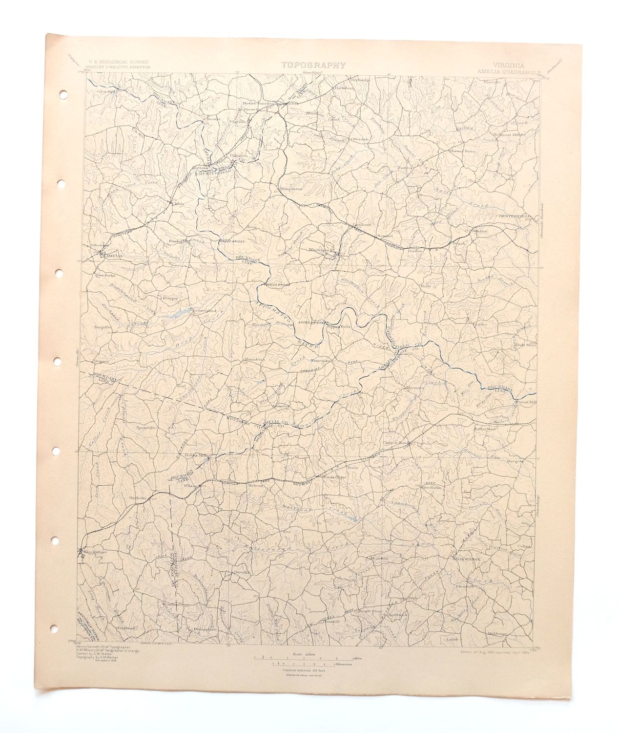

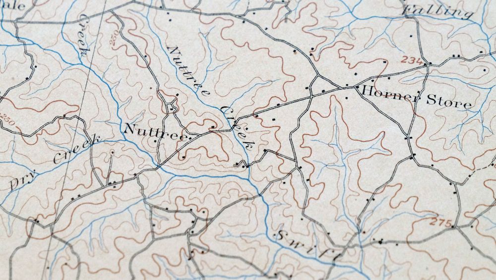
Amelia Virginia Richmond Bon Air USGS Topo Map 1904 Antique
$74
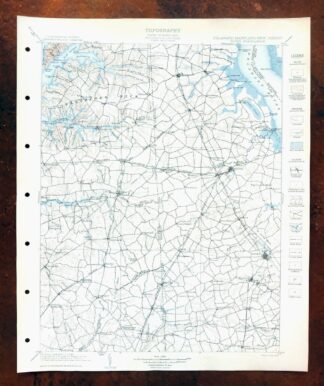
This is a 30-minute USGS topographic sheet, a 1897 edition printed in 1904, and after 122 years it survives in excellent condition – never folded, smooth and flat, on thick stock, with a flawless map area. The quad spans a stretch of central Virginia south of Richmond, taking in Amelia, Chesterfield, Dinwiddie, and Nottoway counties along with communities like Winterpock, Moseley, and Sutherland, while the edge of the Richmond area reaches the northern part of the sheet. Drawn from an 1895 field survey under geographer Henry Gannett and engraved in 1897, it shows the area long before the Richmond suburbs spread outward, and it comes from an uncommonly well-preserved collection. The reverse carries printed reference material on reading the map.
In stock
This antique sheet is an 1897 edition of the Amelia Virginia USGS topographic map. It is an authentic 122-year-old 1904 United States Geological Survey print in excellent condition.
HOW THIS MAP CAN BE USED
In addition to making a fascinating conversation piece, this sheet would look great in a frame or on display, make a unique and prized gift for anyone interested in this area, be perfect as a reference for genealogy studies or general historical research, or fill that missing piece in your collection.
FEATURES SHOWN ON THE MAP
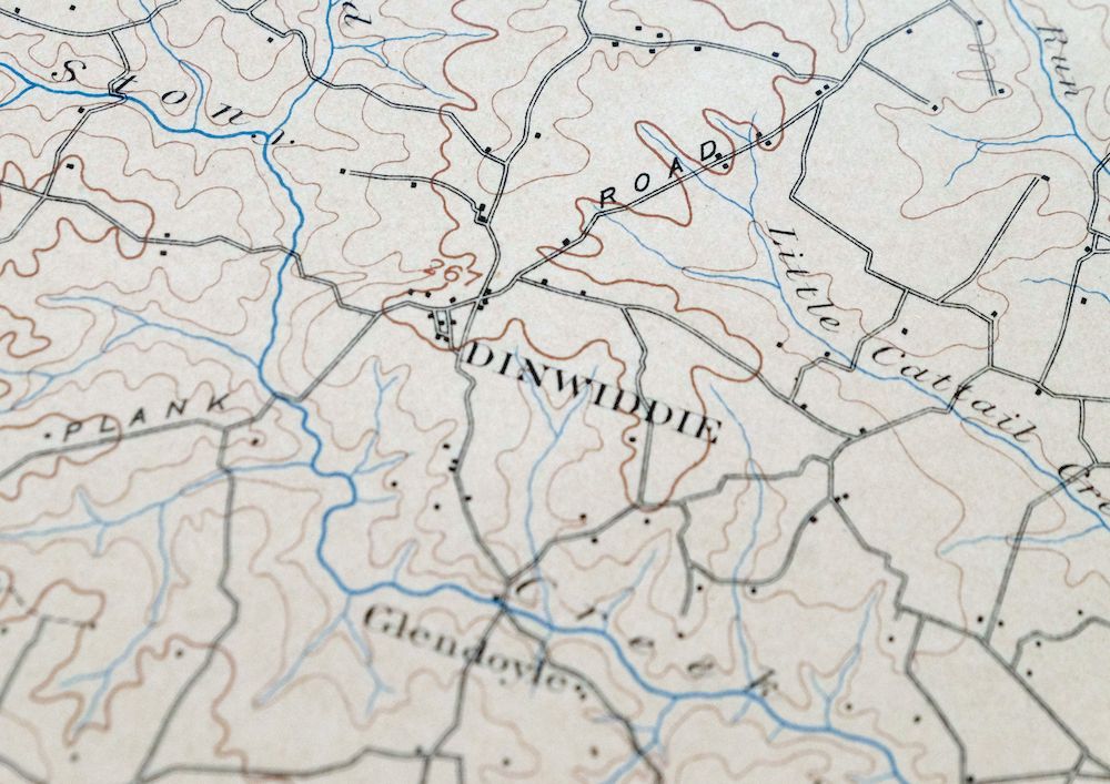
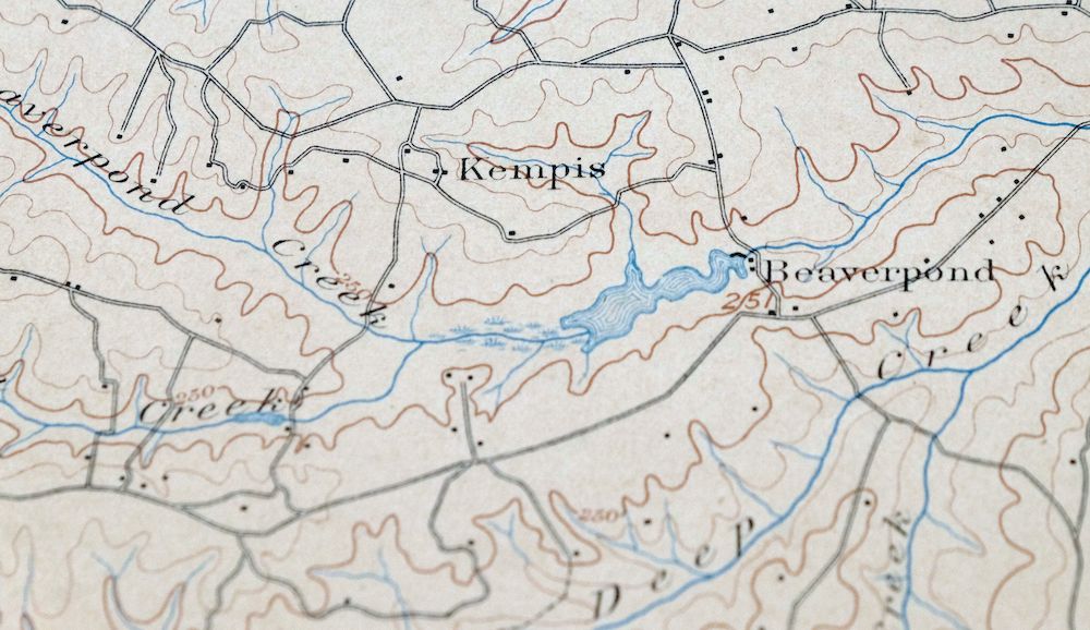
The Amelia 30-minute map shows cities and towns, roads, railroads, rivers, creeks, elevation contour lines, public land survey lines, county, state, and other administrative boundaries as they existed at the time of the survey in 1895.
A VALUABLE HISTORICAL RECORD
Maps from the USGS 30-minute series have been out of print for many years. They have never been common and original prints are increasingly difficult to find. For areas where the 30-minute map was produced, it is usually the first large-scale survey done by the USGS for that area. These are a valuable historical record, as they contain many placenames and features that have been dropped from more recent series’ and editions.
Nearby maps
-
Farmville Virginia Blackstone Rice USGS Topographic Map 1914
$55 Add to cart -

Palmyra Virginia Lake Monticello Dillwyn USGS Topo Map 1907
$75 Add to cart -
Appomattox Virginia Brookneal Toga USGS Topographic Map 1912
$55 Add to cart -

Mount Vernon Virginia Washington Accokeek USGS Topo Map 1912
$200 Add to cart -

Luray Virginia Front Royal Stanley USGS Topographic Map 1910
$115 Add to cart -
Staunton Virginia Stuarts Draft USGS Topographic Map 1913
$90 Add to cart -

Natural Bridge Virginia Covington Selma USGS Topo Map 1911
$62 Add to cart -
Patuxent Maryland Washington Bowie USGS 30-Min Topo Map 1907
$65 Add to cart -

Franklin West Virginia Petersburg Onego USGS Topo Map 1914
$49 Add to cart -

Jarratt Virginia Stony Creek Yale USGS Topographic Map 1951
$38 Add to cart -
White Plains Virginia Triplet Ebony USGS Topo Map 1944
$39 Add to cart -
Rocky Mount North Carolina Wilson Red Oak USGS Topo Map 1965
$48 Add to cart -
Vanceboro North Carolina Ernul USGS Topo Map 1968 Vintage
$45 Add to cart -

Winchester Virginia Middletown Inwood USGS Topo Map 1916
$82 Add to cart -

Patapsco Maryland Baltimore Jessup USGS Topographic Map 1908
$96 Add to cart -

Romney West Virginia Keyser Delray USGS Topographic Map 1909
$80 Add to cart -

Tolchester Maryland Dundalk Essex USGS Topo Map 1908 Antique
$145 Add to cart -
Dover Delaware Bombay Hook NWR Middletown USGS Topo Map 1906
$47 Add to cart -

Nicholas West Virginia Summersville Cowen USGS Topo Map 1912
$54 Add to cart -

Chambersburg Pennsylvania Guilford USGS Topographic Map 1964
$40 Add to cart -

Needmore Pennsylvania Crystal Spring USGS Topo Map 1947
$44 Add to cart -

Clearville Pennsylvania USGS 15-Min Topo Map 1945 Vintage
$42 Add to cart -

Hyndman Pennsylvania Buffalo Mills USGS 15-Min Topo Map 1967
$40 Add to cart -

Sutton West Virginia Glenville Elk River USGS Topo Map 1907
$75 Add to cart