MAP DETAILS | |
|---|---|
| TITLE | Milford |
| STATE | Pennsylvania, New Jersey, New York |
| LOCATION | 25 miles north of Newton, NJ |
| SERIES | 15-minute |
| SURVEYED | 1913 Field Survey |
| GEOGRAPHER | R.B. Marshall |
| ENGRAVED | 1915 |
| EDITION | 1915 |
| PRINTED | 1915 |
| PRINT NOTES | Thick paper stock, includes woodland tint (green to indicate vegetated areas) |
| SCALE | 1:62500 |
| CONTOUR INTERVAL | 20 feet |
| SHEET DIMENSIONS | 16 1/2 x 20 inches |
| MAP DIMENSIONS | 13 1/8 x 17 1/2 inches |
| COVERAGE AREA | 13 x 17 miles |
| SOURCE | From an uncommonly well-preserved collection |
| MAP NOTES | A fascinating historical snapshot surveyed before the modern highway system, showing historic travel routes, rail lines, river crossings, and placenames. |
| SHEET CONDITION For maps of this vintage, effort is made to note all visible flaws, no matter how minor. | |
| OVERALL CONDITION | Excellent |
| SHEET NOTES | very lightly handled, never folded, smooth and flat |
| MAP AREA | flawless map area |
| COLLARS | no wear or tears, no markings, no blemishes, hole punches along left collar |
| MAP COVERAGE Quadrangle extent overlaid on current basemap. | |
| BACKSIDE LEGEND | |
 A map summary is printed on the back side of the Milford sheet similar to the one shown in the picture. It outlines the history, purpose, and status of the USGS mapping program at the time of the printing in 1915. It also provides instructions on how to read contour lines and a description of how they are used to depict the terrain. At the bottom of the page is a legend showing all of the symbols used to represent the cultural, relief, and water features found on the map. | |
| PLACENAMES Depending on map series and survey date, all of the features listed below may not be shown on this map. This list contains features that currently exist or historically existed within the area covered by the map. The list can be used as a reference to determine if this map covers your area of interest. Placenames are listed alphabetically next to each feature type. | |
| CITIES AND TOWNS (CURRENT) | Barryville, Greeley, Milford, and Pond Eddy |
| COUNTIES COVERED | Orange, Pike, Sullivan, and Sussex |
| FEDERAL LAND UNITS | Delaware Water Gap National Recreation Area |
| RIVERS AND STREAMS | Adams Creek, Bear Brook, Beerskill, Bush Kill, Conashaugh Creek, Craft Brook, Crawford Branch, Cummins Creek, Deep Brook, Delaware River, Dimmick Meadow Brook, Dingmans Creek, Dry Brook, Fish Cabin Creek, Gin Brook, Grassy Brook, Halfway Brook, Lackawaxen River, Laurel Brook, Little Bush Kill, Little Flat Brook, Long Meadow Brook, Maple Brook, Mill Brook, Mongaup River, Panther Creek, Pinchot Brook, Pond Eddy Creek, Rattlesnake Creek, Raymondskill Creek, Savantine Creek, Sawkill Creek, Shohola Creek, Sloat Brook, Swale Brook, Twin Lakes Creek, Vandermark Creek, Vantine Brook, Walker Lake Creek, and White Brook |
| WATER BODIES | Bald Hill Swamp, Beaver Lake, Beaver Pond, Case Ponds, Crescent Lake, Dark Swamp, Fairview Lake, Gold Key Lake, Hirsh Pond, Holiday Lake, Lily Pond, Lochada Lake, Log Tavern Pond, Long Meadow Swamp, Long Swamp, Marcel Lake, Middaugh Pond, Nelson Swamp, Nichecronk Pond, Nitche Pond, Nyce Lake, Pine Crest Lake, Rio Reservoir, Sawkill Pond, Shohola Marsh Reservoir, Silver Lake, Silver Springs Lake, Stairway Lake, Sunrise Lake, Sylvania Lake, Twin Lakes, Verga Pond, Walker Lake, Woodpecker Lake, and York Lake |
| Pennsylvania Locations: Camp Speers, Cliff Park Inn Golf Course, Conashaugh Lakes, Marcel Lake Estate, New Jersey Camp, Pocono Mountain Water Forest, and Shohola Falls Trails End. Areas: Buckhorn Natural Area. Administrative Boundaries: Township of Blooming Grove, Township of Dingman, Borough of Milford, Township of Milford, Township of Shohola, and Township of Westfall. Mountains, Peaks, and Summits: Bald Hill, Foster Hill, German Hill, The Knob, Little Bald Hill, Pine Hill, Pow Wow Hill, and Round Hill. Parks: State Game Lands Number 116 and State Game Lands Number 209. Trails: Bald Hill Trail, Lost Cabin Trail, and Maple Brook Trail. Drainages: Balliard Creek, Bear Brook, Conashaugh Creek, Craft Brook, Crawford Branch, Cummins Creek, Deep Brook, Dimmick Meadow Brook, Dry Brook, Dwarfs Kill, Gin Brook, Grassy Brook, Gum Brook, Lackawaxen River, Laurel Brook, Long Meadow Brook, Maple Brook, Panther Creek, Pinchot Brook, Poison Brook, Pond Eddy Creek, Rattlesnake Creek, Raymondskill Creek, Sap Brook, Savantine Creek, Sawkill Creek, Shohola Creek, Sloat Brook, Swale Brook, Twin Lakes Creek, Vandermark Creek, Vantine Brook, and Walker Lake Creek. Churches: Saint Anns Church, Saint Jacobi Church, and Saint Marks Church. Lakes and Ponds: Hirsh Pond, Little Walker Lake, Log Tavern Pond, Nichecronk Pond, Nitche Pond, Twin Lakes, Verga Pond, and Woodpecker Lake. Waterfalls: Pinchot Falls, Raymondskill Falls, and Shohola Falls. Dams: Adams Brook Dam, Beaver Lake Lodge Dam, Beaver Pond Dam, Cadoo Dam, Camp Massad Dam, Camp Netimus Dam, Cresent Lake Dam, Felix Fold Dam, Gregory Dam, Gun Club Dam, Hirsch Dam, Lily Pond Dam, Marcel Lake Dam, Metz Dam, Phillips Dam, Pocono Woodland Lake Dam, Pond Lily Dam, Richartz Dam, Roth Dam, Rowe Dam, Sawkill Dam, Sawkill Pond Dam, Shohola Marsh Dam, Spring House Dam, Springhouse Dam, Stairway Hunt Club Dam, Twin Lakes Dam, Upper Morningstar Dam, Walker Lake Dam, White Dam, and Winkler Dam. Bluffs: The Cliff. Bays: Wallowing Hole. Airports: Myer Airport. Swamps: Bald Hill Swamp, Bear Rock Swamp, Bushkill Swamp, Crooked Swamp, Dark Swamp, DuBois Swamp, Laurel Swamp, Long Swamp, Nelson Swamp, Nicks Swamp, Sap Swamp, and Townsend Swamp. Schools: Dingman Delaware Elementary School, Franklin School, Long Meadow School, Quicktown School, Shohola Elementary School, Shohola School, Spring Brook School, and Union School. Ridges: Aces Ridge, Buckhorn Ridge, Cranberry Ridge, Pine Knot Ridge, Red Ridge, Tarburner Ridge, and Yellow Pine Ridge. Reservoirs and Tanks: Adams Brook Reservoir, Beaver Lake, Beaver Pond, Camp Netimus Lake, Case Ponds, Crescent Lake, Fairview Lake, Gold Key Lake, Lily Pond, Marcel Lake, Middaugh Pond, Milford Reservoir, Pine Crest Lake, Pocono Woodland Lake, Sawkill Pond, Shohola Marsh Reservoir, Silver Lake, Silver Springs Lake, Stairway Lake, Sunrise Lake, and Walker Lake. Flats: Wild Meadows. Towers: Buckhorn Ridge Fire Tower. | |
| New Jersey Parks: Hainesville Fish and Wildlife Management Area. Drainages: Beerskill, Shimers Brook, and White Brook. Islands: Minisink Island, Namanock Island, and Quicks Island. Churches: Minisink Church, Saint Thomas Church, and Sandystone Church. Lakes and Ponds: Holiday Lake. Swamps: Long Meadow Swamp. | |
| New York Locations: Minisink Battlefield Memorial. Administrative Boundaries: Town of Lumberland. Mountains, Peaks, and Summits: Tink Hill. Drainages: Beaver Brook, Bush Kill, Hickok Brook, Fish Cabin Creek, Halfway Brook, Mill Brook, and Mongaup River. Churches: Hillside Church and Sacred Heart Church. Lakes and Ponds: Lochada Lake. Reservoirs and Tanks: Rio Reservoir. | |
| SHIPPING AND RETURNS | |
 This map sheet will be carefully rolled in a sturdy tube and shipped via the US Postal Service. If you find that the sheet you receive is not as described in the listing, you may ship it back to us for a refund of the purchase price. | |


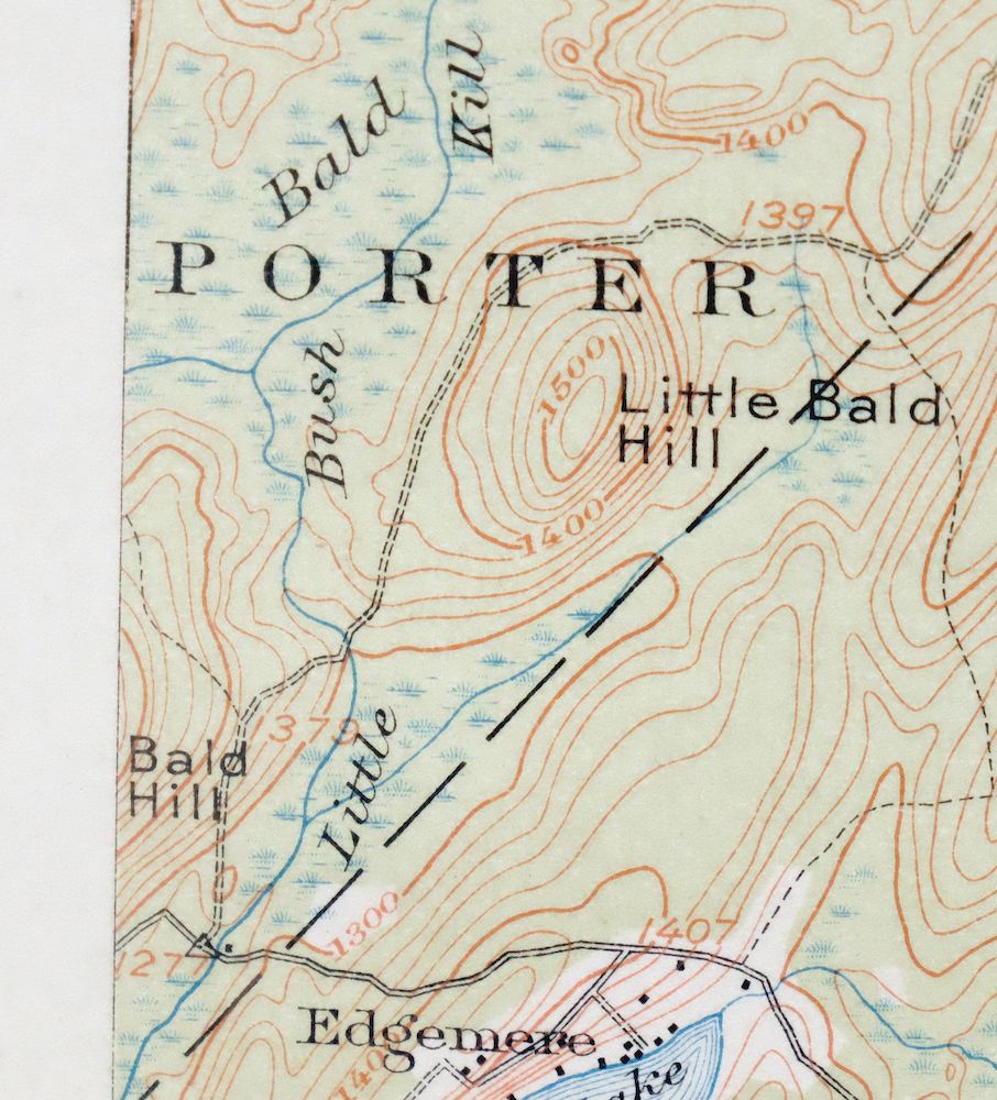


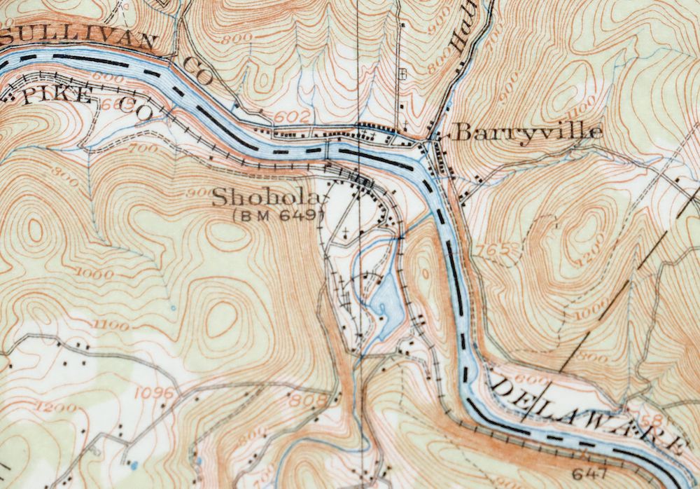
Milford Pennsylvania Lackawaxen Pond Eddy USGS Topo Map 1915
$58
Printed in its year of first publication, 1915, this USGS 15-minute topographic sheet is in excellent condition, never folded, smooth and flat on thick stock, with hole punches along the left collar. Named for the Pennsylvania town of Milford, the quad spans a point where Pennsylvania, New York, and New Jersey meet, taking in Pike, Orange, Sullivan, and Sussex counties along with Lackawaxen, Birchwood Lakes, and communities such as Pond Eddy, Greeley, and Barryville. Surveyed in 1913, before the modern highway system, it records the era’s travel routes, rail lines, river crossings, and placenames, and comes from an uncommonly well-preserved collection. The reverse carries printed reference material on reading the map.
In stock
This antique sheet is a 1915 edition of the Milford Pennsylvania USGS topographic map. It is an authentic 111-year-old United States Geological Survey print in excellent condition.
HOW THIS MAP CAN BE USED
In addition to making a fascinating conversation piece, this sheet would look great in a frame or on display, make a unique and prized gift for anyone interested in this area, be perfect as a reference for genealogy studies or general historical research, or fill that missing piece in your collection.
FEATURES SHOWN ON THE MAP
The Milford 15-minute map shows cities and towns, roads, railroads, rivers, creeks, elevation contour lines, public land survey lines, county, state, and other administrative boundaries as they existed at the time of the survey in 1913. All known structures (houses, businesses, churches, schools, barns, cabins, etc) are also shown, with exceptions in some urban areas, where only landmark buildings may be shown.
A VALUABLE HISTORICAL RECORD
Maps from the 15-minute series for the continental United States are no longer produced or printed by the USGS and original prints are becoming increasingly difficult to find. They are a valuable historical record for an area, as they contain many placenames and features that have been dropped from more recent maps.
Nearby maps
-
Hawley Pennsylvania Tafton USGS 15-Min Topo Map 1964 Vintage
$44 Add to cart -
Wallpack New Jersey Newton Crandon Lakes USGS Topo Map 1916
$95 Add to cart -

Damascus Pennsylvania Honesdale USGS Topo Map 1964 Vintage
$35 Add to cart -

Goshen New York Middletown Warwick USGS Topographic Map 1913
$55 Add to cart -
Honesdale Pennsylvania Carbondale Waymart USGS Topo Map 1945
$49 Add to cart -

Schunemunk New York Newburgh Kiryas Joel USGS Topo Map 1915
$65 Add to cart -
Starrucca Pennsylvania Hancock Lakewood USGS Topo Map 1964
$40 Add to cart -

West Point New York Newburgh Peekskill USGS Topo Map 1912
$75 Add to cart -
Susquehanna Pennsylvania Hallstead USGS 15-Min Topo Map 1959
$46 Add to cart -

Tunkhannock Pennsylvania Dalton Glenburn USGS Topo Map 1952
$40 Add to cart -

Harlem New York New York Yonkers USGS Topo Map 1913 Antique
$250 Add to cart -

Hazleton Pennsylvania Lansford Tamaqua USGS Topo Map 1956
$48 Add to cart -
Olyphant Pennsylvania Scranton Dunmore USGS Topo Map 1960
$37 Add to cart -

Park Ridge New Jersey New City Ridgewood USGS Topo Map 1963
$45 Add to cart -

Wilkes-barre East Pennsylvania Laurel Run USGS Topo Map 1959
$36 Add to cart -
Kingston Pennsylvania Wilkes-Barre USGS Topographic Map 1959
$39 Add to cart -
Wilkes-barre West Pennsylvania Nanticoke USGS Topo Map 1958
$30 Add to cart -

Plainfield New Jersey Edison Somerset USGS Topo Map 1965
$42 Add to cart -

Hazleton Pennsylvania McAdoo Jeddo USGS Topographic Map 1962
$47 Add to cart -

New Brunswick New Jersey Spotswood Edison USGS Topo Map 1965
$32 Add to cart -
Delhi New York Davenport USGS 15-Min Topo Map 1911 Antique
$52 Add to cart -
Le Raysville Pennsylvania Little Meadows USGS Topo Map 1965
$41 Add to cart -

Quakertown Pennsylvania Lansdale Perkasie USGS Topo Map 1911
$95 Add to cart -

Trenton New Jersey Philadelphia Levittown USGS Topo Map 1907
$150 Add to cart
