MAP DETAILS | |
|---|---|
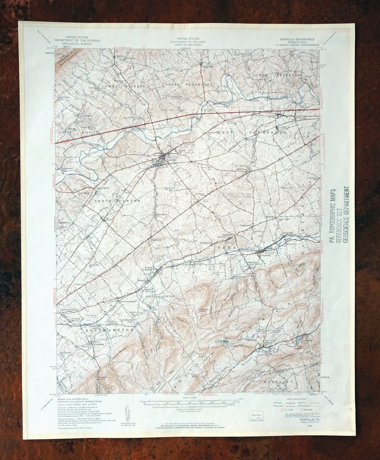
| TITLE | Newville |
| STATE | Pennsylvania |
| LOCATION | Vicinity of Shippensburg |
| SERIES | 15-minute |
| SURVEYED | 1951 and 1952 Aerial and Field Survey |
| EDITION | 1952 |
| PRINTED | 1959 |
| PRINT NOTES | Thick paper stock |
| SCALE | 1:62500 |
| CONTOUR INTERVAL | 20 feet |
| SHEET DIMENSIONS | 17 x 21 inches |
| MAP DIMENSIONS | 13 3/8 x 17 1/2 inches |
| COVERAGE AREA | 13 x 17 miles |
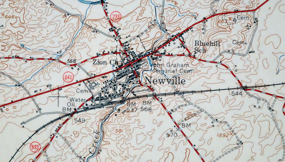
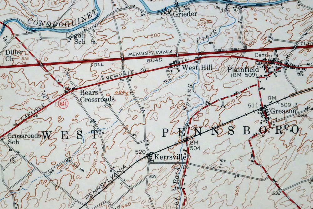
| MAP NOTES | Surveyed before the advent of the modern interstate system, showing all houses known at the time of survey. |
| SHEET CONDITION For maps of this vintage, effort is made to note all visible flaws, no matter how minor. | |
| OVERALL CONDITION | Very Good |
| SHEET NOTES | lightly handled, never folded |
| MAP AREA | flawless map area |
| COLLARS | no markings, edge protectors applied, no edge tears, library stamp in right collar |
| MAP COVERAGE Quadrangle extent overlaid on current basemap. | |
| PLACENAMES Depending on map series and survey date, all of the features listed below may not be shown on this map. This list contains features that currently exist or historically existed within the area covered by the map. The list can be used as a reference to determine if this map covers your area of interest. Placenames are listed alphabetically next to each feature type. | |
| CITIES AND TOWNS (CURRENT) | Newville, Plainfield, Shippensburg, and Walnut Bottom |
| COUNTIES COVERED | Adams, Cumberland, Franklin, and Perry |
| RIVERS AND STREAMS | Alexanders Spring Creek, Back Creek, Big Spring Creek, Bloser Creek, Brandy, Bulls Head Branch, Cold Spring Run, Conodoguinet Creek, Doubling Gap Creek, Green Spring Creek, Iron Run, Locust Creek, Mount Rock Spring Creek, Mountain Creek, Opossum Creek, Rock Run, South Branch Laurel Run, Thomson Creek, Three Square Hollow Run, Toms Run, Whisky Run, and Yellow Breeches Creek |
| WATER BODIES | Big Pond, Fuller Lake, and Opossum Lake |
| Locations: Big Pond Furnace, Big Spring State Fish Hatchery, Buzzards Rocks Vista, Camp Michaux, Center, Cumberland Golf Course, Doners Station, Greythorne Station, Huntsdale State Fish Hatchery, and Pine Grove Furnace Stack. Administrative Boundaries: Township of Cooke, Township of Dickinson, Township of Jackson, Township of Lower Frankford, Township of Lower Mifflin, Borough of Newville, Township of North Newton, Township of Penn, Township of South Newton, Township of Southampton, Township of Upper Frankford, and Township of Upper Mifflin. Mountains, Peaks, and Summits: Big Flat Tower, Buck Ridge Tower, Chimney Rocks, Lewis Rocks, Long Mountain, Pinnacle Mountain, Pole Steeple, Sliding Rock Mountain, Sunset Rocks, and Tobacco Patch Mountain. Valleys and Canyons: Bettem Hollow, Dead Woman Hollow, Hairy Springs Hollow, Irishtown Gap Hollow, Kellars Gap Hollow, Kings Gap Hollow, Peach Orchard Hollow, Reservoir Hollow, State Road Hollow, Sthromes Hollow, and Watery Hollow. Parks: Kings Gap State Park, Pine Grove Furnace State Park, State Game Lands Number 169, and Tumbling Run Game Preserve. Trails: Boundary Trail, Ant Mount Trail, Hammonds Rocks Trail, Kings Gap Hollow Trail, Maple Hollow Trail, Pine Plantation Trail, Pole Bridge Trail, Ridge Trail, Rock Skree Trail, Scenic Vista Trail, and Watershed Trail. Drainages: Brandy, Back Creek, Big Spring Creek, Bloser Creek, Bulls Head Branch, Center Creek, Doubling Gap Creek, Green Spring Creek, Iron Run, Locust Creek, Mount Rock Spring Creek, Opossum Creek, Rock Run, Sage Run, Thomson Creek, Three Square Hollow Run, Toms Run, West Branch Mount Rock Spring Creek, and Whisky Run. Mines: Tomstown Dolomite Quarry. Churches: Bethany Church, Church of Christ, Church of the Brethren, Dickinson Church, Diller Church, Doubling Gap Church, McAllister School and Church, Opossum Hill Union Church, Pentecostal Church, Pine Grove Chapel, Saint Eleanor Regina, Saint Peters Upper Frankford Church, South Fairview Church, South Mountain Chapel, Stone Church, and Zion Church. Lakes and Ponds: Big Pond, Fuller Lake, and Laurel Forge Pond. Buildings: Alterton Station. Dams: Black Dam, Laurel Dam, and Opossum Lake Dam. Bluffs: Sunset Rocks. Basins: Cleversburg Sink. Airports: Lash Airport and Shippensburg Airport. Schools: Bears School, Big Spring School, Bluehill School, Bridgewater School, Center School, Cherry Grove School, Chestnut Crossroads School, Chestnut Grove School, Council Bluff School, Cumminsville School, Fairview School, Forest School, Frankford Elementary School, Gillespie School, Green Hill School, Locust Point School, Logan School, Mount Hope School, Mount Pleasant School, Mount Zion School, Newton Township Consolidated School, Oak Flat School, Oakville School, Opossum Hill School, Palmtown School, Penn Township Consolidated School, Pine Grove School, Pine Road School, Plainfield Emementary School, Savannah School, Shady Grove School, Spring Hill School, State Road School, Stone School, Stouts School, Thorne Grove School, West Pennsboro School, and Whisky Run School. Ridges: Big Hill and Little Rocky Ridge. Reservoirs and Tanks: Chambersburg Reservoir, Laurel Lake, and Opossum Lake. Springs: Alexander Spring, Big Spring, Bucher Spring, Cool Spring, Green Spring, Hairy Spring, Huntsdale Hatchery Springs, and Mount Rock Spring. | |
| SHIPPING AND RETURNS | |
 This map sheet will be carefully rolled in a sturdy tube and shipped via the US Postal Service. If you find that the sheet you receive is not as described in the listing, you may ship it back to us for a refund of the purchase price. | |
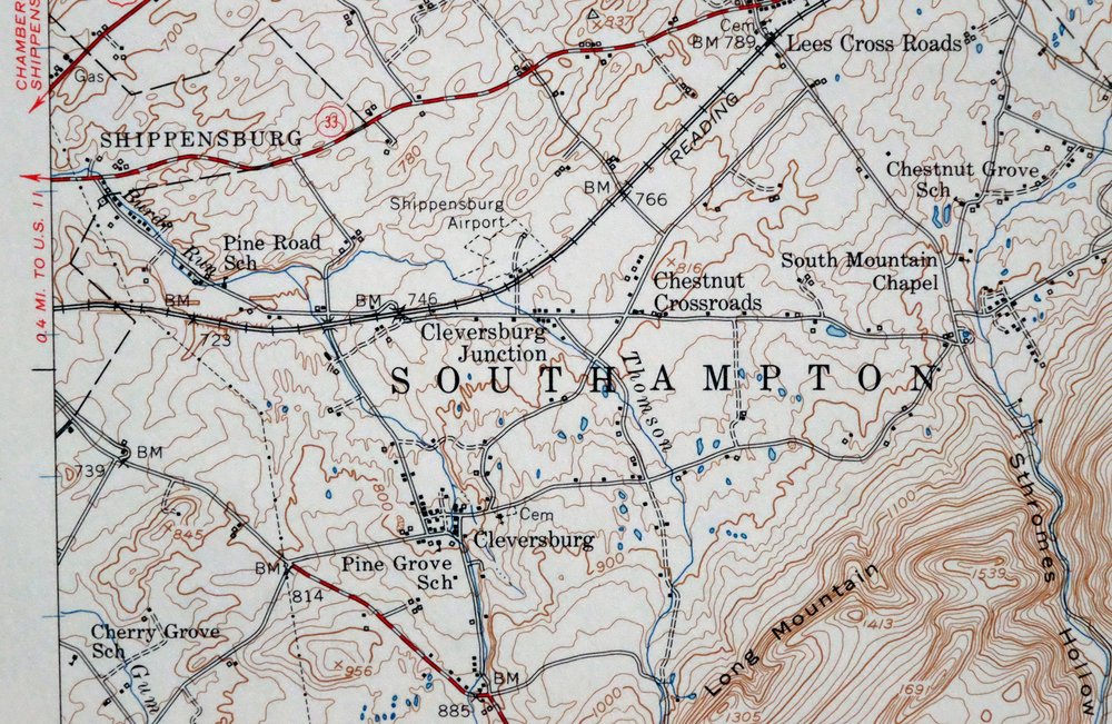
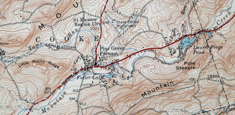
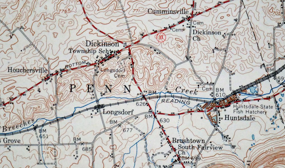
Newville Pennsylvania Shippensburg USGS 15-Min Topo Map 1959
$40
This 15-minute USGS / Army Corps of Engineers topographic sheet is a 1952 edition, printed in 1959, and the print is in very good condition: lightly handled, never folded, with a flawless map area and edge protectors applied. Drawn from a 1951 and 1952 aerial and field survey, the quad takes in south-central Pennsylvania around Newville and Shippensburg, with Plainfield and Walnut Bottom within its boundaries across parts of Cumberland, Franklin, Adams, and Perry counties. Surveyed before the modern interstate system reached the region, it marks all houses known at the time of survey, giving a house-by-house record of the countryside as it stood at mid-century. Printed on thick stock, and having never been folded, the sheet lies flat.
In stock
This vintage sheet is a 1952 edition of the Newville Pennsylvania USGS topographic map. It is an original 67-year-old 1959 United States Geological Survey print in very good condition.
HOW THIS MAP CAN BE USED
In addition to making a fascinating conversation piece, this sheet would look great in a frame or on display, make a unique and prized gift for anyone interested in this area, be perfect as a reference for genealogy studies or general historical research, or fill that missing piece in your collection. Maps of this vintage are printed on durable stock and are well-suited for outdoor activities and recreation of all kinds, including hiking, backpacking, hunting, rafting and kayaking, backcountry skiing, geocaching, general exploration, treasure hunting, etc.
FEATURES SHOWN ON THE MAP
The Newville 15-minute map shows cities and towns, roads, railroads, utilities and energy infrastructure, rivers, creeks, elevation contour lines, public land survey lines, county, state, and other administrative boundaries as they existed at the time of the survey in 1951 and 1952. All known structures (houses, businesses, churches, schools, barns, cabins, etc) are also shown.
A VALUABLE HISTORICAL RECORD
Maps from the 15-minute series for the continental United States are no longer produced or printed by the USGS and original prints are becoming increasingly difficult to find. They are a valuable historical record for an area, as they contain many placenames and features that have been dropped from more recent maps.
Nearby maps
-

Carlisle Pennsylvania Schlusser USGS Topographic Map 1964
$45 Add to cart -

Loysville Pennsylvania Landisburg USGS Topo Map 1966 Vintage
$42 Add to cart -

Chambersburg Pennsylvania Guilford USGS Topographic Map 1964
$40 Add to cart -

Hummelstown Pennsylvania Hershey Palmyra USGS Topo Map 1965
$37 Add to cart -

Needmore Pennsylvania Crystal Spring USGS Topo Map 1947
$44 Add to cart -

Lykens Pennsylvania Valley View Reinerton USGS Topo Map 1964
$45 Add to cart -

Lancaster Pennsylvania Columbia Lititz USGS Topo Map 1943
$58 Add to cart -

Centre Hall Pennsylvania Bellefonte Zion USGS Topo Map 1958
$28 Add to cart -

Clearville Pennsylvania USGS 15-Min Topo Map 1945 Vintage
$42 Add to cart -
Bellefonte Pennsylvania Boalsburg USGS Topographic Map 1961
$44 Add to cart -

Philipsburg Pennsylvania Stormstown USGS Topo Map 1964
$34 Add to cart -

New Holland Pennsylvania Ephrata Akron USGS Topo Map 1962
$48 Add to cart -

Bedford Pennsylvania Schellsburg USGS Topo Map 1958 Vintage
$42 Add to cart -

Wernersville Pennsylvania Mohnton USGS Topographic Map 1963
$45 Add to cart -

Quarryville Pennsylvania Oxford USGS Topographic Map 1944
$53 Add to cart -

Hyndman Pennsylvania Buffalo Mills USGS 15-Min Topo Map 1967
$40 Add to cart -
Snow Shoe SE Pennsylvania Orviston USGS Topographic Map 1962
$34 Add to cart -

Patapsco Maryland Baltimore Jessup USGS Topographic Map 1908
$195 Add to cart -
Snow Shoe Pennsylvania Clarence USGS Topo Map 1963 Vintage
$30 Add to cart -

Catawissa Pennsylvania Bloomsburg Ashland USGS Topo Map 1960
$45 Add to cart -

Winchester Virginia Middletown Inwood USGS Topo Map 1916
$100 Add to cart -

Honey Brook Pennsylvania Thorndale USGS Topographic Map 1962
$49 Add to cart -

Hughesville Pennsylvania Millville Iola USGS Topo Map 1962
$42 Add to cart -
Snow Shoe NW Pennsylvania Sproul SF USGS Topo Map 1962
$32 Add to cart
