MAP DETAILS | |
|---|---|
| TITLE | Lakeport |
| STATE | California |
| LOCATION | 20 miles east of Ukiah |
| SERIES | 15-minute |
| SURVEYED | 1957 and 1958 Aerial and Field Survey |
| EDITION | 1958 |
| PRINTED | 1977 |
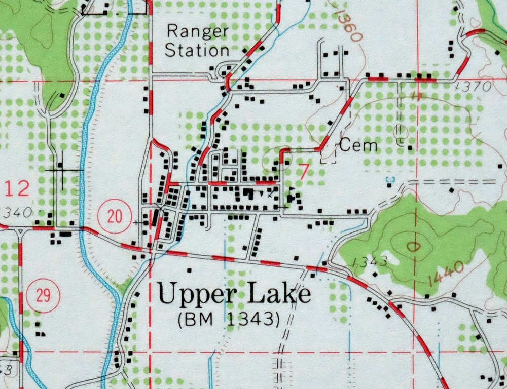
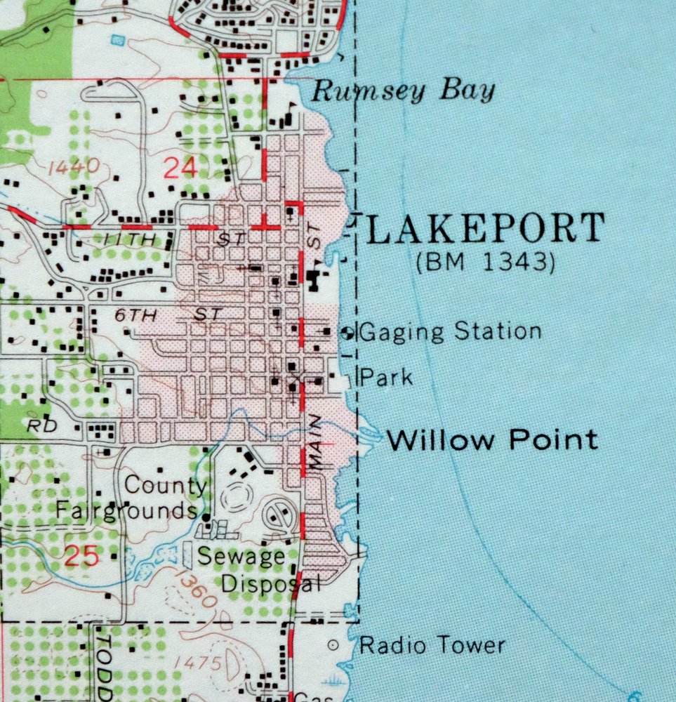
| PRINT NOTES | Includes woodland tint (green to indicate vegetated areas). A reddish tint is used to indicate urban areas where only landmark buildings are shown. |
| SCALE | 1:62500 |
| CONTOUR INTERVAL | 80 feet |
| SHEET DIMENSIONS | 18 x 22 inches |
| MAP DIMENSIONS | 13 5/8 x 17 1/2 inches |
| COVERAGE AREA | 13 x 17 miles |
| SHEET CONDITION For maps of this vintage, effort is made to note all visible flaws, no matter how minor. | |
| OVERALL CONDITION | Excellent |
| SHEET NOTES | very lightly handled, never folded, smooth and flat |
| MAP AREA | flawless map area |
| COLLARS | no wear or tears, no markings, no blemishes |
| MAP COVERAGE Quadrangle extent overlaid on current basemap. | |
| PLACENAMES Depending on map series and survey date, all of the features listed below may not be shown on this map. This list contains features that currently exist or historically existed within the area covered by the map. The list can be used as a reference to determine if this map covers your area of interest. Placenames are listed alphabetically next to each feature type. | |
| CITIES AND TOWNS (CURRENT) | Lakeport, Lucerne, Nice, North Lakeport, and Upper Lake |
| COUNTIES COVERED | Lake and Mendocino |
| FEDERAL LAND UNITS | Mendocino National Forest |
| RIVERS AND STREAMS | Adobe Creek, Alder Creek, Alley Creek, Benmore Creek, Clover Creek, Cooper Creek, Dayle Creek, Dorr Creek, East Fork Middle Creek, Forbes Creek, Hendricks Creek, Long Valley Creek, Lyons Creek, Manning Creek, Middle Creek, Morrison Creek, North Fork Bartlett Creek, North Fork Cache Creek, Poge Creek, Pool Creek, Rattlesnake Creek, Rice Fork, Scotts Creek, South Fork Bartlett Creek, South Fork Long Valley Creek, South Fork Scotts Creek, Thompson Creek, and Wild Bill Creek |
| WATER BODIES | Burger Lake, Clear Lake, Eachus Lake, Hidden Lake, Little Borax Lake, Lower Blue Lake, and Ora Lake |
| Populated Place: Lakeport, Lucerne, Upper Lake, Buckingham Park, Finley, Nice, Pepperwood Grove, Rose Place, Saratoga Springs, Soda Bay, and Wild Bill Place. Locations: Alley Camp, Crabtree Lodge, Howes Camp, Hunter Ranch, Lake View Campground, Scotts Valley Rancheria, Buckingham Golf Course, Cole Creek Campground, George C Hoberg Vista Point, High Glade Lookout, Jones Ranch, Kelsey Creek Campground, Lakeport Yacht Club, Lower Bayview Campground, Lucerne Christian Conference Center, Nylanders Frontier Village Shopping Center, Quercus Ranch, Shoreline Shopping Center, Upper Bayview Campground, Upper Lake Substation, Vista Point Shopping Center, and Lakeport Auto Movies. Areas: Upper Lake. Administrative Boundaries: Big Valley Rancheria, Lake County, Robinson Rancheria, Upper Lake Rancheria, City of Lakeport, and Lakeport Division. Mountains, Peaks, and Summits: Charlie Alley Peak, Dali-Dona, Elk Knob, Hells Peak, Hog Point, Hunter Point, Lakeport Peak, Little Pinnacle, Orr Peak, Pine Mountain, Pinnacle Rock, Red Rock, Round Mountain, Scotts Mountain, Sky Rock, Twin Knobs, White Rock Mountain, Windy Point, Youngs Peak, Bartlett Mountain, Bloody Island, Brewery Hill, Griner Peak, McCabe Point, Poe Mountain, and Sleeper Peak. Valleys and Canyons: Bachelor Valley, Clover Valley, Decy Canyon, Elk Canyon, Fall Canyon, Live Oak Hollow, McGregor Canyon, Middle Creek Valley, Pierce Canyon, Scotts Valley, Smith Canyon, Swede Canyon, Tea Canyon, White Rock Canyon, Elk Valley, Forty Springs Valley, Twin Valley, and Wilson Valley. Woods: Pilot Grove. Parks: Bloody Island Massacre Historical Marker, Clear Lake State Park, Lakeside Park, Keeling Park, Lake County Fairgrounds, and Library Park. Trails: Bucknell Trail, Elk Knob Trail, Middle Creek Flat Trail, Middle Mountain Firebreak, Dorn Nature Trail, and Indian Nature Trail. Drainages: Adobe Creek, Alder Creek, Alley Creek, Benmore Creek, Chair Creek, Clover Creek, Cole Creek, Cooper Creek, Dayle Creek, Dorr Creek, Forbes Creek, Forty Springs Valley, Gilbert Creek, Hendricks Creek, Kelsey Creek, Kirkpatrick Creek, Lyons Creek, McGaugh Slough, Middle Creek, Morrison Creek, Poge Creek, Pool Creek, Rattlesnake Creek, Robinson Creek, Rumsey Slough, Salt Flat Creek, Scotts Creek, South Fork Scotts Creek, Thompson Creek, Twin Valley, Wild Bill Creek, Wilson Valley, and Old Kelsey Creek. Islands: Shag Rock and Tule Island. Capes: Henderson Point, Kono Tayee Point, Long Tule Point, Quercus Point, Reeves Point, Rocky Point, and Willow Point. Churches: Big Valley Community Church, Church of Christ, First Baptist Church, First Church of Christ Scientist, Kingdom Hall of Jehovahs Witnesses, Lakeport Bible Church, Lakeport Christian Center, Lakeport Full Gospel Assembly Church, New Life Foursquare Church, Queen of the Rosary Catholic Church, Saint Johns Episcopal Church, Saint Mary Immaculate Roman Catholic Church, Seventh Day Adventist Church, Sonrise Assembly Charismatic Church, and Clear Lake Baptist Church. Post Office: Finley Post Office, Lakeport Post Office, Lucerne Post Office, Nice Post Office, Upper Lake Post Office, and Witter Springs Post Office. Hospitals: Sutter Lakeside Hospital. Lakes and Ponds: Burger Lake, Clear Lake, Eachus Lake, Hidden Lake, Little Borax Lake, Lower Blue Lake, and Ora Lake. Buildings: Clear Lake State Park Visitor Center, Lake County Courthouse, Lake County Museum, Lakeport City Hall, Lakeport Library, Upper Lake Branch Lake County Library, Kelseyville Fire Station, Lake County Sheriff's Office, Lake County Sheriff's Office Lucerne Substation, Lakeport Cinema 5, Lakeport Fire Protection District Station 50, Lakeport Fire Protection District Station 52, Lakeport Police Department, Northshore Fire Protection District Station 80 Lucerne Headquarters, Northshore Fire Protection District Station 85 Nice, Northshore Fire Protection District Station 90 Upper Lake, and Soper-Reese Theatre. Dams: Lake Company Sanitation District 2 1081-002 Dam. Bluffs: Lincoln Bluff. Gaps: Bartlett Mountain Summit and Low Gap. Channels: The Narrows. Bayous and Sloughs: Shirley Slough. Bends: Horseshoe Bend. Beaches: Laurel Beach. Bays: Berger Bay, Dorn Bay, Rumsey Bay, and Soda Bay. Basins: Elk Valley and Paradise Valley. Airports: Ferndale Resort Seaplane Base. Swamps: Rodman Slough. Census: Lucerne Census Designated Place, Nice Census Designated Place, North Lakeport Census Designated Place, Upper Lake Census Designated Place, and Soda Bay Census Designated Place. Schools: Clear Lake High School, Glen Eden School, Upper Lake High School, Westlake Seventh-day Adventist School, Lakeport Elementary School, Lucerne Elementary School, Mendocino College, Natural High School, Terrace Middle School, Upper Lake Elementary School, Clover Valley Continuation High School, The Grove School, and Upper Lake Middle School. Ridges: Alder Spring Ridge, Boundary Ridge, Buck Ridge, Dave Phelps Ridge, French Ridge, High Valley Ridge, Hogback Ridge, John Alley Ridge, Ladder Ridge, Long Valley Ridge, Mary Ann Ridge, McCabe Ridge, McGregor Ridge, Middle Mountain, Pitney Ridge, Sam Alley Ridge, Wild Bill Ridge, and Windy Ridge. Reservoirs and Tanks: Lakeport Lake, Tule Lake, and Clear Lake. Flats: Carter Glades, Ellis Flat, Middle Creek Flat, Salt Flat, Sawmill Flat, The Pocket, Willow Flat, and Wyman Glade. Towers: KXBX-AM (Lakeport) and KXBX-FM (Lakeport). Pillars: Buzzard Rock and Telegraph Rock. Springs: Big Soda Spring, Hazel Spring, High Glade Spring, Madrone Spring, Plank Cabin Spring, Sulphur Spring, and Witter Springs. Cemetery: Hartley Cemetery, Robinson Cemetery, Saint Mary's Catholic Cemetery, and Upper Lake Cemetery. | |
| SHIPPING AND RETURNS | |
 This map sheet will be carefully rolled in a sturdy tube and shipped via the US Postal Service. If you find that the sheet you receive is not as described in the listing, you may ship it back to us for a refund of the purchase price. | |
Lakeport California Lucerne Nice USGS Topo Map 1977 Vintage
$44
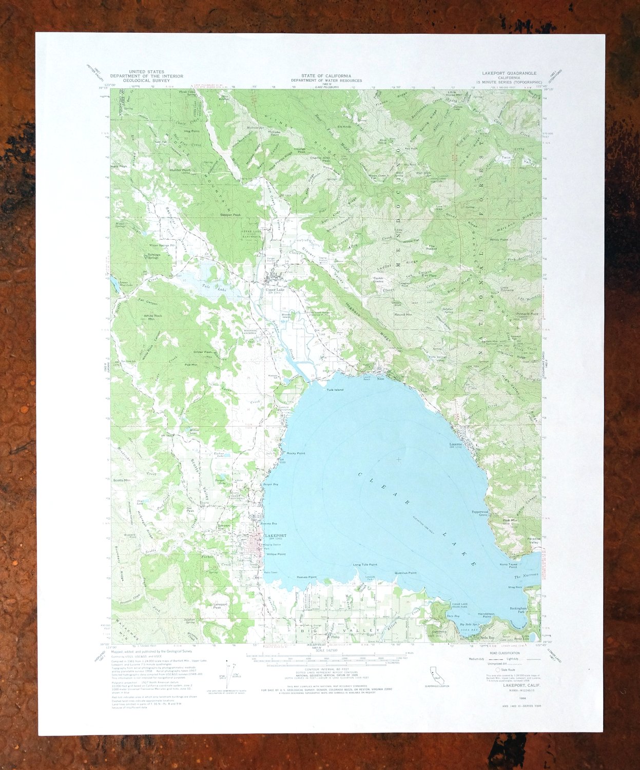
A 1958 edition printed in 1977, this USGS 15-minute topographic sheet is in excellent condition, never folded and kept smooth and flat with a flawless map area. It covers a stretch of Lake and Mendocino counties about 20 miles east of Ukiah, taking in Lakeport on the western shore of Clear Lake along with Lucerne, Nice, Upper Lake, and North Lakeport, and reaching into part of the Mendocino National Forest. The 80-foot contour interval traces the hilly country ringing California’s largest natural lake, giving anyone with ties to the Clear Lake basin a clear read on its towns and terrain in the mid-century era.
In stock
This vintage sheet is a 1958 edition of the Lakeport California USGS topographic map. It is an original 49-year-old 1977 United States Geological Survey print in excellent condition.
HOW THIS MAP CAN BE USED
In addition to making a fascinating conversation piece, this sheet would look great in a frame or on display, make a unique and prized gift for anyone interested in this area, be perfect as a reference for genealogy studies or general historical research, or fill that missing piece in your collection. Maps of this vintage are printed on durable stock and are well-suited for outdoor activities and recreation of all kinds, including hiking, backpacking, hunting, rafting and kayaking, backcountry skiing, geocaching, general exploration, treasure hunting, etc.
FEATURES SHOWN ON THE MAP
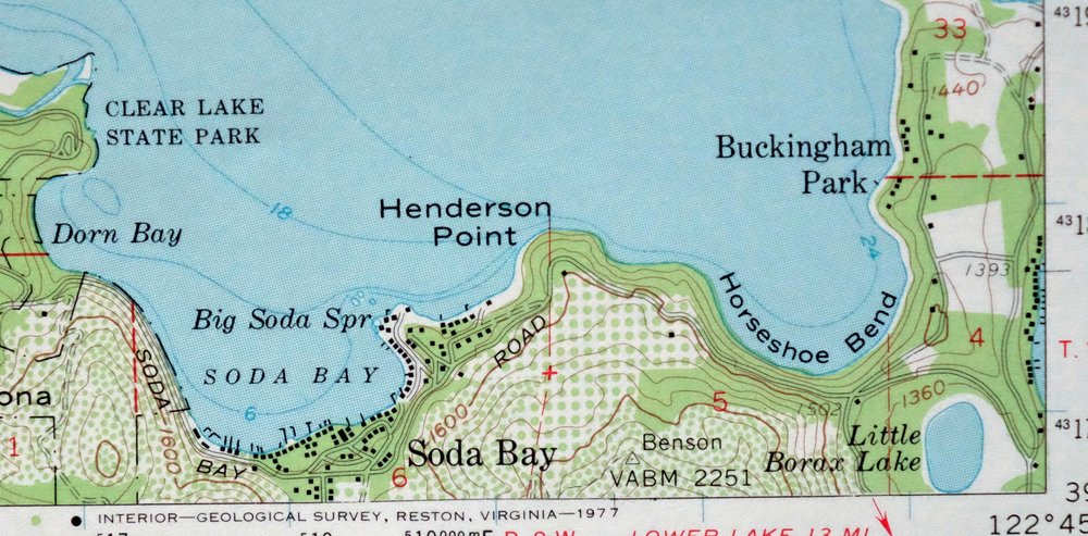
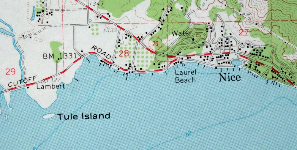
The Lakeport 15-minute map shows cities and towns, roads, railroads, utilities and energy infrastructure, rivers, creeks, elevation contour lines, public land survey lines, county, state, and other administrative boundaries as they existed at the time of the survey in 1957 and 1958. A reddish tint is used on this sheet to indicate urban areas where only landmark buildings are depicted. Outside of those areas, all known structures (houses, businesses, churches, schools, barns, cabins, etc) are shown.
A VALUABLE HISTORICAL RECORD
Maps from the 15-minute series for the continental United States are no longer produced or printed by the USGS and original prints are becoming increasingly difficult to find. They are a valuable historical record for an area, as they contain many placenames and features that have been dropped from more recent maps.
Nearby maps
-
Stonyford California USGS 15-Min Topo Map 1967 Vintage
$39 Add to cart -
Fruto California Stony Creek Nye Creek USGS Topo Map 1944
$30 Add to cart -
Mount Vaca California Fairfield Vacaville USGS Topo Map 1967
$40 Add to cart -
Gridley California Oroville Live Oak USGS Topo Map 1959
$37 Add to cart -

Richardson Springs California Chico Nord USGS Topo Map 1966
$35 Add to cart -
Piercy California USGS 15-Min Topographic Map 1971 Vintage
$33 Add to cart -
Petaluma Point California Novato USGS Topographic Map 1951
$30 Add to cart -

San Rafael California Mill Valley Tiburon USGS Topo Map 1966
$60 Add to cart -
San Quentin California Richmond Tiburon USGS Topo Map 1980
$46 Add to cart -
Port Chicago California Concord Martinez USGS Topo Map 1956
$38 Add to cart -
Panther Spring California USGS 15-Min Topo Map 1970 Vintage
$36 Add to cart -
Pittsburg California Concord Fairfield USGS Topo Map 1965
$38 Add to cart -
Point Bonita California Sausalito USGS Topographic Map 1955
$44 Add to cart -
San Francisco South California USGS 7.5-Min Topo Map 1975
$47 Add to cart -
Hunters Point California Oakland USGS Topographic Map 1969
$38 Add to cart -

Redwood Point California Fremont Hayward USGS Topo Map 1948
$24 Add to cart -

Newark California Fremont Hayward USGS Topo Map 1948 Vintage
$47 Add to cart -
Palo Alto California Redwood City Ladera USGS Topo Map 1969
$45 Add to cart -
Manzanita Lake California Viola USGS Topo Map 1974 Vintage
$39 Add to cart -
Lamoine California Shasta Lake USGS Topo Map 1974 Vintage
$40 Add to cart -
Mindego Hill California Palo Alto USGS Topo Map 1980 Vintage
$32 Add to cart -
Westwood California USGS 15-Min Topographic Map 1961 Vintage
$38 Add to cart -
Sierraville California Calpine Loyalton USGS Topo Map 1969
$40 Add to cart -
Susanville California Janesville USGS Topo Map 1966 Vintage
$39 Add to cart